METAR & TAF K65
K65 does not publish a METAR.
Showing the nearest reporting station: KTQK (SCOTT CITY MUNI) · 18.9 NM away. Conditions at K65 may differ.
METAR · KTQK
Observed 12:55Z
KTQK 271255Z AUTO 20007KT 10SM CLR 24/16 A2990 RMK AO2 T02360156
- Wind
- 200° @ 7 kt
- Visibility
- 10 SM
- Temp / Dew
- 24°C / 16°C
- Altimeter
- 29.90 inHg
- Clouds
- CLR
- Density alt
- 4,551 ft
- Ceiling
- Unlimited
- Rules
- VFR
Airport info & contacts
Manager on record, flight service, ARTCC, attendance schedule and pattern altitude — published by the FAA and refreshed every 28 days.
Location
- From city
- 1 NM NW
- VFR sectional
- WICHITA
- ARTCC
- ZKC · KANSAS CITY
- NOTAM facility
- ICT (NOTAM-D)
Airport manager
- Name
- MARK CALLENDER
- Phone
- 620-397-3691
- Address
- BOX 115, DIGHTON KS 67839
Flight service · Hours
- FSS ICT
- WICHITA1-800-WX-BRIEF
- Attendance
- Unattended
Frequencies
Tap any row to copy the frequency to your clipboard.
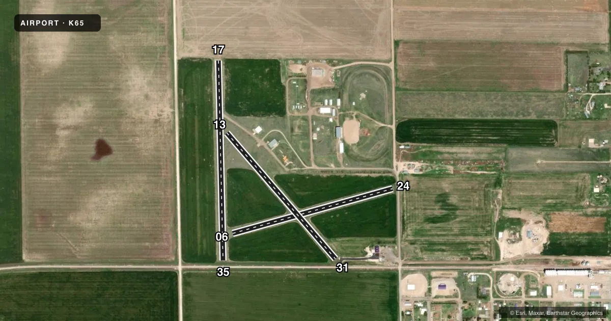
Runways & pattern
Full pagePattern entry · RWY 17
LEFT TRAFFIC| Runway | Heading (°M) | Length | Surface | Traffic |
|---|---|---|---|---|
| 17/35Favored | 170° / 350° | 2,400 ft | ASPH | Standard L |
| 06/24 | 65° / 245° | 2,000 ft | TURF | Standard L |
| 13/31 | 130° / 310° | 2,000 ft | TURF | Standard L |
Runway end performance
| End | TORA | TODA | ASDA | LDA | VGSI | Approach lights | Obstruction |
|---|---|---|---|---|---|---|---|
| 17 | — | — | — | — | — | — | 65', pline, 1300' from thr, 0' R of cntrln, slope 16 |
| 24 | — | — | — | — | — | — | 15', road, 18' from thr, 0' R of cntrln, slope 0 |
| 31 | — | — | — | — | — | — | 23', rr, 80' from thr, 0' R of cntrln, slope 3 |
Declared distances in feet. TORA = takeoff run available, TODA = takeoff distance, ASDA = accelerate-stop, LDA = landing distance.
Airport sketch
Runways drawn to scale from FAA survey coordinates, rendered over satellite imagery. Not for navigation.
Approaches & charts
Services on the field
Fuel grades, oxygen, maintenance, ramp storage and lighting — as declared to the FAA by the airport operator.
Fuel & services
- Fuel
- Not available
- Oxygen (bottled)
- Not available
- Oxygen (bulk)
- Not available
- Airframe repair
- Not available
- Power plant repair
- Not available
- Other services
- AGRI
Ramp & ground
- Transient storage
- Tie-down
- Landing fee
- No fee published
- Lighting schedule
- SEE RMK
- Wind indicator
- Yes
- Segmented circle
- No
Fuel & FBOs
Cheapest 100LL and Jet A on the field and nearby. Always confirm with the FBO before taxi.
Airport notes
Surface conditions, obstructions, local procedures, lighting outages and other notes published with each FAA cycle.
General notes
- PUBLIC PHONE AVBL - 620-397-8651.
- FOR CD CTC KANSAS CITY ARTCC AT 913-254-8508.
Lighting notes
- ACTVT LIRL 17/35 - CTAF.
Approach & departure obstructions
- 17+3 FT FENCE POST 50 FT FROM AER 17.
- 35+23 FT RR 65 FT FROM AER CL.
- 24RWY 24, 13, 31-NO RWY END MARKINGS.
- 06CONTROLLING OBSTN EXCEEDS A 45 DEG SLP.
Other notes
- EXISTED PRIOR TO 1959.
VFR map & nearby airports
VFR sectional. Tap any ICAO chip to open that airport.
Key facts · K65
Answer card- ICAO
- K65
- Name
- DIGHTON
- Location
- DIGHTON, KANSAS
- Elevation
- 2,779 ft MSL
- Traffic pattern altitude
- 3,779 ft MSL (1,000 AGL)
- Control tower
- Non-towered (use CTAF)
- Total runways
- 3
- Longest runway
- 17/35 · 2,400 ft
- Published ILS approaches
- 0
- Published frequencies
- 1
- Magnetic variation
- 9°
- Current flight rules
- VFR
- Current wind
- 200° at 7 kt
- Favored runway now
- RWY 17
Dighton Airport sits in Dighton, Kansas. The field elevation is 2,779 ft MSL. It has three runways. The longest is runway 17/35 at 2,400 ft. The airport is not towered. CTAF is 122.9.
No ILS approaches are published here. Pattern altitude is not published, so use the standard 1,000 ft AGL for light piston operations unless the current Chart Supplement says otherwise. That puts the pattern at 3,779 ft MSL based on the listed field elevation. Runway 17 has a 3-foot fence post near the approach end. Runway 35 has a railroad close in to the approach end centerline. Runway 06 has a controlling obstruction that exceeds a 45 degree slope. Runways 24, 13 and 31 have no runway end markings.
There are no on-field FBOs listed. Plan on self-sufficiency. A public phone is available if you need to call ahead. Low intensity runway lights on 17 and 35 are activated on CTAF. For clearance delivery, contact Kansas City ARTCC. This is a small, non-towered field in western Kansas. Expect the usual high-plains considerations. Watch density altitude, crosswind control and runway condition before you commit.