METAR & TAF 1QK
1QK does not publish a METAR.
Showing the nearest reporting station: KOEL (OAKLEY MUNI) · 27.5 NM away. Conditions at 1QK may differ.
METAR · KOEL
Observed 13:15Z
KOEL 271315Z AUTO 35006KT 10SM CLR 27/13 A2989 RMK AO1 T02740129
- Wind
- 350° @ 6 kt
- Visibility
- 10 SM
- Temp / Dew
- 27°C / 13°C
- Altimeter
- 29.89 inHg
- Clouds
- CLR
- Density alt
- 4,747 ft
- Ceiling
- Unlimited
- Rules
- VFR
Airport info & contacts
Manager on record, flight service, ARTCC, attendance schedule and pattern altitude — published by the FAA and refreshed every 28 days.
Location
- From city
- 2 NM S
- VFR sectional
- WICHITA
- ARTCC
- ZDV · DENVER
- NOTAM facility
- ICT (NOTAM-D)
Airport manager
- Name
- PATRICK RICHMEIER
- Phone
- 785-299-0219
- Address
- PO BOX 413, 312 LINCOLN ST, QUINTER KS 67752
Flight service · Hours
- FSS ICT
- WICHITA1-800-WX-BRIEF
Frequencies
Tap any row to copy the frequency to your clipboard.
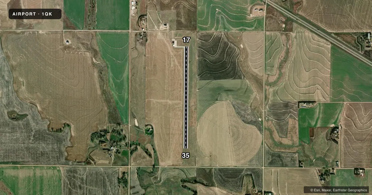
Runways & pattern
Full pagePattern entry · RWY 35
LEFT TRAFFICRunway end performance
| End | TORA | TODA | ASDA | LDA | VGSI | Approach lights | Obstruction |
|---|---|---|---|---|---|---|---|
| 35 | — | — | — | — | — | — | 60', tree, 1320' from thr, 420' R of cntrln, slope 18 |
Declared distances in feet. TORA = takeoff run available, TODA = takeoff distance, ASDA = accelerate-stop, LDA = landing distance.
Airport sketch
Runways drawn to scale from FAA survey coordinates, rendered over satellite imagery. Not for navigation.
Approaches & charts
Services on the field
Fuel grades, oxygen, maintenance, ramp storage and lighting — as declared to the FAA by the airport operator.
Fuel & services
- Fuel
- Not available
- Oxygen (bottled)
- Not available
- Oxygen (bulk)
- Not available
- Airframe repair
- Not available
- Power plant repair
- Not available
Ramp & ground
- Transient storage
- Tie-down
- Lighting schedule
- SEE RMK
- Beacon schedule
- SS-SR
- Beacon
- White / Green (civil land)(WG)
- Wind indicator
- Yes
- Segmented circle
- No
Fuel & FBOs
Cheapest 100LL and Jet A on the field and nearby. Always confirm with the FBO before taxi.
Airport notes
Surface conditions, obstructions, local procedures, lighting outages and other notes published with each FAA cycle.
General notes
- FOR CD CTC DENVER ARTCC 303-651-4257.
Lighting notes
- ACTVT MIRL RWY 17/35 - CTAF.
VFR map & nearby airports
VFR sectional. Tap any ICAO chip to open that airport.
Key facts · 1QK
Answer card- ICAO
- 1QK
- Name
- GOVE COUNTY
- Location
- QUINTER, KANSAS
- Elevation
- 2,637.1 ft MSL
- Traffic pattern altitude
- 3,637.1 ft MSL (1,000 AGL)
- Control tower
- Non-towered (use CTAF)
- Total runways
- 1
- Longest runway
- 17/35 · 4,000 ft
- Published ILS approaches
- 0
- Published frequencies
- 1
- Magnetic variation
- 5°
- Current flight rules
- VFR
- Current wind
- 350° at 6 kt
- Favored runway now
- RWY 35
Gove County Airport sits near Quinter, Kansas. The field elevation is 2,637.1 ft MSL. It has one runway. Runway 17/35 is 4,000 ft long with a concrete surface. There is no control tower. CTAF is 122.9.
No ILS approaches are published here. The traffic pattern altitude is not published, so use standard 1,000 ft AGL for light piston operations unless the current Chart Supplement says otherwise. The airport is in open country at higher plains elevation, so performance planning matters on warm days. The published remarks also note that runway 17/35 lights are activated by CTAF. For clearance delivery, contact Denver ARTCC at 303-651-4257.
There are no on-field FBOs listed in the facts. Verify fuel and service availability with the airport operator or the FBO directly by phone before you go. If you are arriving at night, brief the lighting activation and make sure you have the current airport data in hand before departure.