METAR & TAF KHYS
Current METAR
Observed 15:56Z
KHYS 271556Z AUTO 22011KT 10SM CLR 36/17 A2983 RMK AO2 SLP074 T03560167 $
- Wind
- 220° @ 11 kt
- Visibility
- 10 SM
- Temp / Dew
- 36°C / 17°C
- Altimeter
- 29.83 inHg
- Clouds
- CLR
- Density alt
- 5,110 ft
- Ceiling
- Unlimited
- Rules
- VFR
Airport info & contacts
Manager on record, flight service, ARTCC, attendance schedule and pattern altitude — published by the FAA and refreshed every 28 days.
Location
- From city
- 3 NM SE
- VFR sectional
- WICHITA
- ARTCC
- ZKC · KANSAS CITY
- NOTAM facility
- HYS (NOTAM-D)
Airport manager
- Name
- JAMIE SALTER
- Phone
- 785-628-7370
- Address
- BOX 490, HAYS KS 67601
Flight service · Hours
- FSS ICT
- WICHITA1-800-WX-BRIEF
- Attendance
- DALGT
Frequencies
Tap any row to copy the frequency to your clipboard.
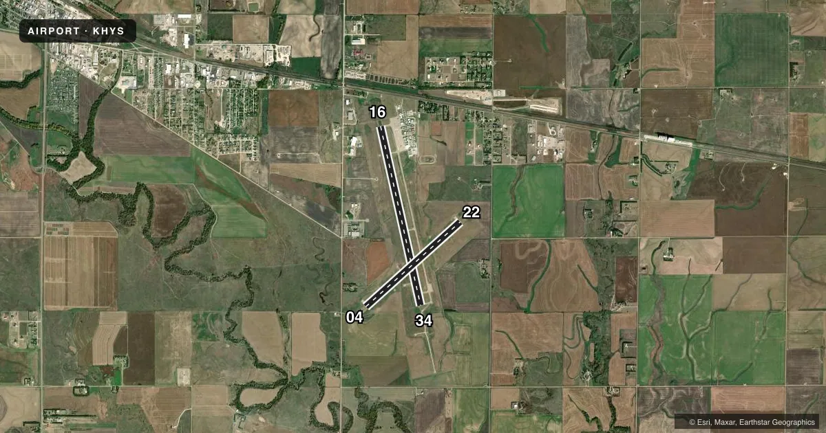
Runways & pattern
Full pagePattern entry · RWY 22
LEFT TRAFFIC| Runway | Heading (°M) | Length | Surface | Traffic |
|---|---|---|---|---|
| 16/34 | 159° / 339° | 6,501 ft | CONC | Standard L |
| 04/22Favored | 40° / 220° | 4,501 ft | CONC | Standard L |
Runway end performance
| End | TORA | TODA | ASDA | LDA | VGSI | Approach lights | Obstruction |
|---|---|---|---|---|---|---|---|
| 16 | 6,501' | 6,501' | 6,501' | 6,501' | PAPI 4-box left(3°) | — | — |
| 34 | 6,501' | 6,501' | 6,501' | 6,501' | PAPI 4-box left(3°) | MALSR | — |
| 04 | 4,500' | 4,500' | 4,500' | 4,500' | PAPI 4-box left(3°) | — | — |
| 22 | 4,500' | 4,500' | 4,500' | 4,500' | PAPI 4-box left(3°) | — | — |
Declared distances in feet. TORA = takeoff run available, TODA = takeoff distance, ASDA = accelerate-stop, LDA = landing distance.
Airport sketch
Runways drawn to scale from FAA survey coordinates, rendered over satellite imagery. Not for navigation.
Approaches & charts
ILS · 1
Services on the field
Fuel grades, oxygen, maintenance, ramp storage and lighting — as declared to the FAA by the airport operator.
Fuel & services
- Fuel
- 100LLA
- Oxygen (bottled)
- Not available
- Oxygen (bulk)
- Not available
- Airframe repair
- Major
- Power plant repair
- Major
- Other services
- AFRT,AGRI,CHTR,INSTR,RNTL
Ramp & ground
- Transient storage
- Tie-down
- Hangar
- Landing fee
- No fee published
- Customs
- Not available
- Lighting schedule
- SEE RMK
- Beacon schedule
- SS-SR
- Beacon
- White / Green (civil land)(WG)
- Wind indicator
- Lighted
- Segmented circle
- Yes
Fuel & FBOs
Cheapest 100LL and Jet A on the field and nearby. Always confirm with the FBO before taxi.
Airport notes
Surface conditions, obstructions, local procedures, lighting outages and other notes published with each FAA cycle.
General notes
- BIRDS AND DEER ON AND IN VCNTY OF THE ARPT.
- FOR FBO HRS OF OPN CTC (785) 628-8881. FOR AFT HRS FUEL CTC FBO.
- FOR CD IF UNA TO CTC ON FSS FREQ, CTC KANSAS CITY ARTCC AT 913-254-8508.
- NO TURF TKOFS OR LDGS ALLOWED ON THE AIRFIELD.
Lighting notes
- ACTVT MALSR RWY 34; REIL RWYS 16, 4 AND 22; PAPI RWYS 16, 34, 4, AND 22; MIRL RWYS 16/34 AND 4/22 - CTAF.
- ULTRALIGHT ACTIVITY ON & INVOF ARPT.
Runway surface & condition
- 04/22PCR VALUE: 80/R/C/W/T
- 16/34PCR VALUE: 270/R/C/W/T
Other notes
- ARPT CLSD TO UNSKED ACR OPNS WITH MORE THAN 30 PSGR SEATS EXCP 24 HRS PPR CALL AMGR 785-625-1011. ARFF INDEX B EQPT IS PROVDD FOR SKEDD ACR OPNS AND IS AVBL FOR UNSKEDD ACR OPNS WITH 24 HR PPR.
- 1EXC JULY 4TH, THANKSGIVING AND CHRISTMAS.
VFR map & nearby airports
VFR sectional. Tap any ICAO chip to open that airport.
Key facts · KHYS
Answer card- ICAO
- KHYS
- Name
- HAYS RGNL
- Location
- HAYS, KANSAS
- Elevation
- 1,999.1 ft MSL
- Traffic pattern altitude
- 2,999.1 ft MSL (1,000 AGL)
- Control tower
- Non-towered (use CTAF)
- Total runways
- 2
- Longest runway
- 16/34 · 6,501 ft
- Published ILS approaches
- 1
- Published frequencies
- 2
- Magnetic variation
- 8°
- Current flight rules
- VFR
- Current wind
- 220° at 11 kt
- Favored runway now
- RWY 22
Hays Rgnl sits in Hays, Kansas at 1,999.1 ft MSL. It has two concrete runways. The longest is 16/34 at 6,501 ft. Runway 04/22 is 4,501 ft. The field is not towered. CTAF and UNICOM are both 122.8. One ILS approach is published for runway 34.
Pattern altitude is not published. Use 1,000 ft AGL for light piston traffic unless local procedures say otherwise. That puts the standard pattern at about 2,999 ft MSL. Check the current Chart Supplement before you go. Ultralight activity is noted on and near the airport. Birds and deer are also present in the area, so keep a sharp scan on approach and in the pattern.
Hays Aircraft is on the field. It carries 100LL and Jet A Prist. Call (785) 628-8881 for FBO hours or after-hours fuel. The airport remarks also note that runway lights and approach lighting are activated on the common traffic advisory frequency. No turf takeoffs or landings are allowed. The airport is closed to unscheduled aircraft operations with more than 30 passenger seats unless prior permission is arranged 24 hours ahead. For a first-time arrival, the big items are the elevation. The non-towered pattern matters too. The runway lighting setup for runway 34 is another item to brief.