METAR & TAF 8V3
8V3 does not publish a METAR.
Showing the nearest reporting station: KAGZ (WAGNER MUNI) · 23.1 NM away. Conditions at 8V3 may differ.
METAR · KAGZ
Observed 18:35Z
KAGZ 271835Z AUTO 05008KT 10SM CLR 34/20 A2986 RMK AO2
- Wind
- 050° @ 8 kt
- Visibility
- 10 SM
- Temp / Dew
- 34°C / 20°C
- Altimeter
- 29.86 inHg
- Clouds
- CLR
- Density alt
- 4,113 ft
- Ceiling
- Unlimited
- Rules
- VFR
Airport info & contacts
Manager on record, flight service, ARTCC, attendance schedule and pattern altitude — published by the FAA and refreshed every 28 days.
Location
- From city
- 1 NM SW
- VFR sectional
- OMAHA
- ARTCC
- ZMP · MINNEAPOLIS
- NOTAM facility
- HON (NOTAM-D)
Airport manager
- Name
- CITY OF PARKSTON
- Phone
- 605-928-3321
- Address
- PO BOX 490, PARKSTON SD 57366
Flight service · Hours
- FSS HON
- HURON1-800-WX-BRIEF
- Attendance
- ALL
Frequencies
Tap any row to copy the frequency to your clipboard.
Runways & pattern
Full pagePattern entry · RWY 33
LEFT TRAFFICRunway end performance
| End | TORA | TODA | ASDA | LDA | VGSI | Approach lights | Obstruction |
|---|---|---|---|---|---|---|---|
| 15 | — | — | — | — | PAPI 2-box right(3°) | — | 49', pole, 1240' from thr, 200' R of cntrln, slope 21 |
| 33 | — | — | — | — | PAPI 2-box left(3°) | — | — |
Declared distances in feet. TORA = takeoff run available, TODA = takeoff distance, ASDA = accelerate-stop, LDA = landing distance.
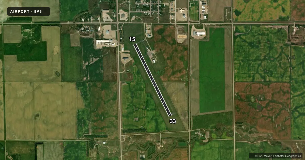
Airport sketch
Runways drawn to scale from FAA survey coordinates, rendered over satellite imagery. Not for navigation.
Approaches & charts
Services on the field
Fuel grades, oxygen, maintenance, ramp storage and lighting — as declared to the FAA by the airport operator.
Fuel & services
- Fuel
- 100LLA
- Other services
- AGRI
Ramp & ground
- Transient storage
- Tie-down
- Landing fee
- No fee published
- Customs
- Not available
- Lighting schedule
- SEE RMK
- Beacon schedule
- SS-SR
- Beacon
- White / Green (civil land)(WG)
- Wind indicator
- Lighted
- Segmented circle
- No
Fuel & FBOs
Cheapest 100LL and Jet A on the field and nearby. Always confirm with the FBO before taxi.
Airport notes
Surface conditions, obstructions, local procedures, lighting outages and other notes published with each FAA cycle.
General notes
- FOR CD CTC MINNEAPOLIS ARTCC AT 651-463-5588.
Lighting notes
- ACTVT PAPI RWY 15 & 33; MIRL RWY 15/33 - CTAF.
Other notes
- AUTOMATED UNICOM.
VFR map & nearby airports
VFR sectional. Tap any ICAO chip to open that airport.
Key facts · 8V3
Answer card- ICAO
- 8V3
- Name
- PARKSTON MUNI
- Location
- PARKSTON, SOUTH DAKOTA
- Elevation
- 1,418.3 ft MSL
- Traffic pattern altitude
- 2,418.3 ft MSL (1,000 AGL)
- Control tower
- Non-towered (use CTAF)
- Total runways
- 1
- Longest runway
- 15/33 · 3,600 ft
- Published ILS approaches
- 0
- Published frequencies
- 1
- Magnetic variation
- 4°
- Current flight rules
- VFR
- Current wind
- 050° at 8 kt
- Favored runway now
- RWY 33
Parkston Muni sits in Parkston, South Dakota. Field elevation is 1,418.3 ft MSL. The airport has one runway. Runway 15/33 is 3,600 ft long and asphalt. There is no control tower. CTAF is 122.9. The remarks say it is an automated UNICOM field. The precision approach path indicator is active on both runway ends. Medium intensity runway lights are also on 15 and 33, with control through CTAF.
No ILS approaches are published here. Pattern altitude is not published in the facts, so use the current Chart Supplement before you go. The field is a simple setup for light piston traffic. The elevation still matters for takeoff performance on warm days. Parkston Municipal Airport is the on-field FBO. It carries 100LL and Jet A. Call (605) 928-3321 for current service details before arrival.
If you need clearance delivery, the Chart Supplement says to contact Minneapolis ARTCC at 651-463-5588. That is useful to have ready if you are filing or need help with a clearance before departure. For a first trip in, plan for a non-towered airport with published lighting on the single runway. Verify current procedures. Check the current Chart Supplement for pattern altitude and any local notes before you launch.