METAR & TAF 4N4
4N4 does not publish a METAR.
Showing the nearest reporting station: KGWR (GWINNER/ROGER MELROE FLD) · 21.3 NM away. Conditions at 4N4 may differ.
METAR · KGWR
Observed 21:35Z
KGWR 272135Z AUTO 30006KT 9SM CLR 31/22 A2983 RMK A01
- Wind
- 300° @ 6 kt
- Visibility
- 9 SM
- Temp / Dew
- 31°C / 22°C
- Altimeter
- 29.83 inHg
- Clouds
- CLR
- Density alt
- 3,373 ft
- Ceiling
- Unlimited
- Rules
- VFR
Airport info & contacts
Manager on record, flight service, ARTCC, attendance schedule and pattern altitude — published by the FAA and refreshed every 28 days.
Location
- From city
- 1 NM NW
- VFR sectional
- TWIN CITIES
- ARTCC
- ZMP · MINNEAPOLIS
- NOTAM facility
- GFK (NOTAM-D)
Airport manager
- Name
- BRUCE OLAND
- Phone
- 701-899-1155
- Address
- 9125 HIGHWAY 18, LIDGERWOOD ND 58053
Flight service · Hours
- FSS GFK
- GRAND FORKS1-800-WX-BRIEF
- Attendance
- Unattended
Frequencies
Tap any row to copy the frequency to your clipboard.
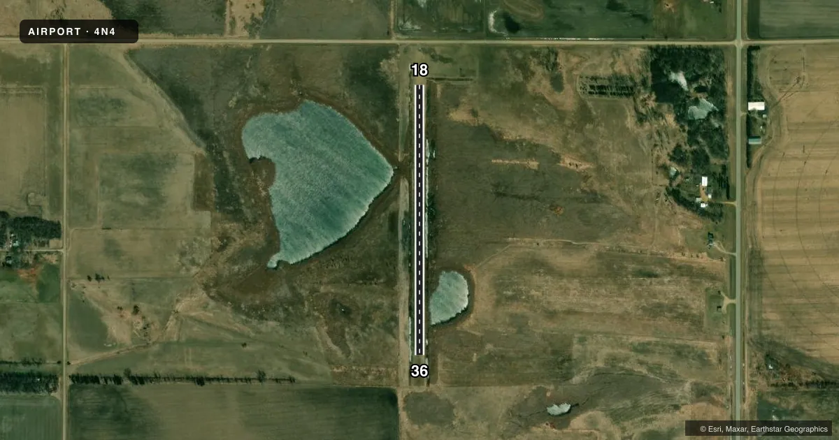
Runways & pattern
Full pagePattern entry · RWY 36
LEFT TRAFFICAirport sketch
Runways drawn to scale from FAA survey coordinates, rendered over satellite imagery. Not for navigation.
Approaches & charts
Services on the field
Fuel grades, oxygen, maintenance, ramp storage and lighting — as declared to the FAA by the airport operator.
Fuel & services
- Fuel
- Not available
Ramp & ground
- Transient storage
- Tie-down
- Wind indicator
- Yes
- Segmented circle
- No
Fuel & FBOs
Cheapest 100LL and Jet A on the field and nearby. Always confirm with the FBO before taxi.
Airport notes
Surface conditions, obstructions, local procedures, lighting outages and other notes published with each FAA cycle.
General notes
- ARPT CLSD IN WINTER MONTHS DUE TO NO SNOW REMOVAL.
- NMRS BIRDS & DEER ON & INVOF ARPT.
- FOR CD CTC MINNEAPOLIS ARTCC AT 651-463-5588.
- ADDL CTC SCOTT WETTSTEIN - CHAIR ARPT AUTH 701-640-1568.
Approach & departure obstructions
- 186FT BRUSH ADJ TO RWY SIDES.
Other notes
- PRVDD THRS ARE LCTD OR DSPLCD TO PRVD 20:1 APCH SFC SLOPE.
- 18/36RWY WIDTH 60 FT IN AREAS WITH STEEP DROP-OFFS INTO WATER. RWY SFC ROUGH.
VFR map & nearby airports
VFR sectional. Tap any ICAO chip to open that airport.
Key facts · 4N4
Answer card- ICAO
- 4N4
- Name
- LIDGERWOOD MUNI
- Location
- LIDGERWOOD, NORTH DAKOTA
- Elevation
- 1,082 ft MSL
- Traffic pattern altitude
- 2,082 ft MSL (1,000 AGL)
- Control tower
- Non-towered (use CTAF)
- Total runways
- 1
- Longest runway
- 18/36 · 2,100 ft
- Published ILS approaches
- 0
- Published frequencies
- 1
- Magnetic variation
- 6°
- Current flight rules
- VFR
- Current wind
- 300° at 6 kt
- Favored runway now
- RWY 36
Lidgerwood Muni (4N4) sits in Lidgerwood, North Dakota. Field elevation is 1,082 ft MSL. The airport has one runway, 18/36, at 2,100 ft. It is a turf strip. There is no control tower. CTAF is 122.9. No ILS approaches are published here.
Pattern altitude is not published. Use the standard 1,000 ft AGL pattern for light piston operations unless the current FAA Chart Supplement says otherwise. The field has no on-field FBOs listed, so plan on self-sufficiency and verify any service needs with the airport operator before you go. Published remarks note birds and deer in the area. They also note winter closure because there is no snow removal. The runway is rough. There are 6-foot brush areas beside runway 18. The runway thresholds are set to support a 20-to-1 approach surface slope. The runway also has steep drop-offs into water in some areas, so taxi and landing rollout deserve attention. This is a non-towered rural field with no published ILS. Check the current FAA Chart Supplement for any current restrictions before flying in. For clearance delivery, Minneapolis ARTCC is listed in the remarks.