METAR & TAF 4E7
4E7 does not publish a METAR.
Showing the nearest reporting station: KABR (ABERDEEN RGNL) · 34.4 NM away. Conditions at 4E7 may differ.
METAR · KABR
Observed 18:53Z
KABR 271853Z AUTO VRB03KT 9SM CLR 31/19 A2986 RMK AO2 SLP099 T03110194
- Wind
- VAR @ 3 kt
- Visibility
- 9 SM
- Temp / Dew
- 31°C / 19°C
- Altimeter
- 29.86 inHg
- Clouds
- CLR
- Density alt
- 3,801 ft
- Ceiling
- Unlimited
- Rules
- VFR
Airport info & contacts
Manager on record, flight service, ARTCC, attendance schedule and pattern altitude — published by the FAA and refreshed every 28 days.
Location
- From city
- 1 NM NE
- VFR sectional
- TWIN CITIES
- ARTCC
- ZMP · MINNEAPOLIS
- NOTAM facility
- GFK (NOTAM-D)
Airport manager
- Name
- KYLE GLYNN
- Phone
- 701-830-0143
- Address
- 8974 HWY 281, ELLENDALE ND 58436
Flight service · Hours
- FSS GFK
- GRAND FORKS1-800-WX-BRIEF
- Attendance
- Unattended
Frequencies
Tap any row to copy the frequency to your clipboard.
Runways & pattern
Full pagePattern entry · RWY 35
LEFT TRAFFIC| Runway | Heading (°M) | Length | Surface | Traffic |
|---|---|---|---|---|
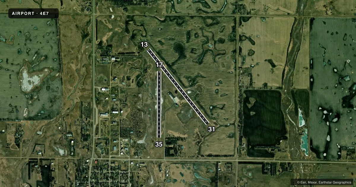
| 13/31 | 134° / 314° | 3,499 ft | ASPH | Standard L |
| 17/35Favored | 173° / 353° | 2,437 ft | TURF | Standard L |
Runway end performance
| End | TORA | TODA | ASDA | LDA | VGSI | Approach lights | Obstruction |
|---|---|---|---|---|---|---|---|
| 13 | — | — | — | — | PAPI 2-box left(3°) | — | — |
| 31 | — | — | — | — | PAPI 2-box left(3°) | — | — |
Declared distances in feet. TORA = takeoff run available, TODA = takeoff distance, ASDA = accelerate-stop, LDA = landing distance.
Airport sketch
Runways drawn to scale from FAA survey coordinates, rendered over satellite imagery. Not for navigation.
Approaches & charts
Services on the field
Fuel grades, oxygen, maintenance, ramp storage and lighting — as declared to the FAA by the airport operator.
Fuel & services
- Fuel
- 100LL
- Oxygen (bottled)
- Not available
- Oxygen (bulk)
- Not available
- Airframe repair
- Not available
- Power plant repair
- Not available
- Other services
- AGRI
Ramp & ground
- Transient storage
- Tie-down
- Hangar
- Landing fee
- No fee published
- Customs
- Not available
- Lighting schedule
- SEE RMK
- Beacon schedule
- SS-SR
- Beacon
- White / Green (civil land)(WG)
- Wind indicator
- Lighted
- Segmented circle
- Yes
Fuel & FBOs
Cheapest 100LL and Jet A on the field and nearby. Always confirm with the FBO before taxi.
Airport notes
Surface conditions, obstructions, local procedures, lighting outages and other notes published with each FAA cycle.
General notes
- FOR RWY CONDS DRG WINTER MONTHS CALL AMGR AT 701-830-0143.
- BIRDS & DEER INVOF ARPT.
- FOR CD CTC MINNEAPOLIS ARTCC AT 651-463-5588.
Lighting notes
- ACTVT MIRL RWY 13/31; PAPI RWY 13 & 31 - CTAF.
Fuel notes
- 100LLSELF SVC AVBL H24 VIA CREDIT CARD.
Runway surface & condition
- 17/35CLSD DRG WINTER MONTHS DUE TO LACK OF SNOW REMOVAL.
Approach & departure obstructions
- 31+60 FT ANT 1720 FT FM THLD 340 FT L OF EXTDD CNTRLN.
Other notes
- PRVDD FENCES DO NO EXCEED OBSTN STDS OF PART 77.
- OWNERKYLE GLYNN, CHAIRMAN ARPT AUTH.
- MANAGERADDL CONTACT JEFF ULMER 701-866-6434.
- AGRIFOR AGRI SVCS CALL 701-351-5066.
VFR map & nearby airports
VFR sectional. Tap any ICAO chip to open that airport.
Key facts · 4E7
Answer card- ICAO
- 4E7
- Name
- ELLENDALE MUNI
- Location
- ELLENDALE, NORTH DAKOTA
- Elevation
- 1,456.6 ft MSL
- Traffic pattern altitude
- 2,456.6 ft MSL (1,000 AGL)
- Control tower
- Non-towered (use CTAF)
- Total runways
- 2
- Longest runway
- 13/31 · 3,499 ft
- Published ILS approaches
- 0
- Published frequencies
- 1
- Magnetic variation
- 7°
- Current flight rules
- VFR
- Current wind
- 000° at 3 kt
- Favored runway now
- RWY 35
Ellendale Muni is in Ellendale, North Dakota. The field elevation is 1,456.6 ft MSL. It has two runways. The longest is runway 13/31 at 3,499 ft asphalt. Runway 17/35 is 2,437 ft turf. There is no control tower. CTAF is 122.9.
No ILS approaches are published here. Pattern altitude is not published, so use the standard 1,000 ft AGL for light piston operations unless the current FAA Chart Supplement says otherwise. The airport has medium intensity runway lights on 13/31. PAPI is available on runways 13 and 31. It is controlled by CTAF. Self-service 100LL is available 24 hours by credit card. There are no on-field FBOs listed.
A first-time pilot should pay attention to the published obstacles near runway 31. There is a 60-foot antenna 1,720 ft from the threshold and 340 ft left of the extended centerline. Birds and deer are also reported in the area. Runway 17/35 is closed during winter months because there is no snow removal. For winter runway conditions, call the airport manager before you go. For clearance delivery, contact Minneapolis ARTCC. If you need agricultural services or airport contact details, those numbers are published in the Chart Supplement.