METAR & TAF D03
D03 does not publish a METAR.
Showing the nearest reporting station: KJMS (JAMESTOWN RGNL) · 38.9 NM away. Conditions at D03 may differ.
METAR · KJMS
Observed 18:56Z
KJMS 271856Z AUTO 35010KT 10SM CLR 29/21 A2987 RMK AO2 SLP104 T02940206
- Wind
- 350° @ 10 kt
- Visibility
- 10 SM
- Temp / Dew
- 29°C / 21°C
- Altimeter
- 29.87 inHg
- Clouds
- CLR
- Density alt
- 4,171 ft
- Ceiling
- Unlimited
- Rules
- VFR
Airport info & contacts
Manager on record, flight service, ARTCC, attendance schedule and pattern altitude — published by the FAA and refreshed every 28 days.
Location
- From city
- 1 NM NE
- VFR sectional
- TWIN CITIES
- ARTCC
- ZMP · MINNEAPOLIS
- NOTAM facility
- GFK (NOTAM-D)
Airport manager
- Name
- LORENCE HOLMGREN
- Phone
- 701-830-2205
- Address
- P.O. BOX 291, KULM ND 58456
Flight service · Hours
- FSS GFK
- GRAND FORKS1-800-WX-BRIEF
- Attendance
- Unattended
Frequencies
Tap any row to copy the frequency to your clipboard.
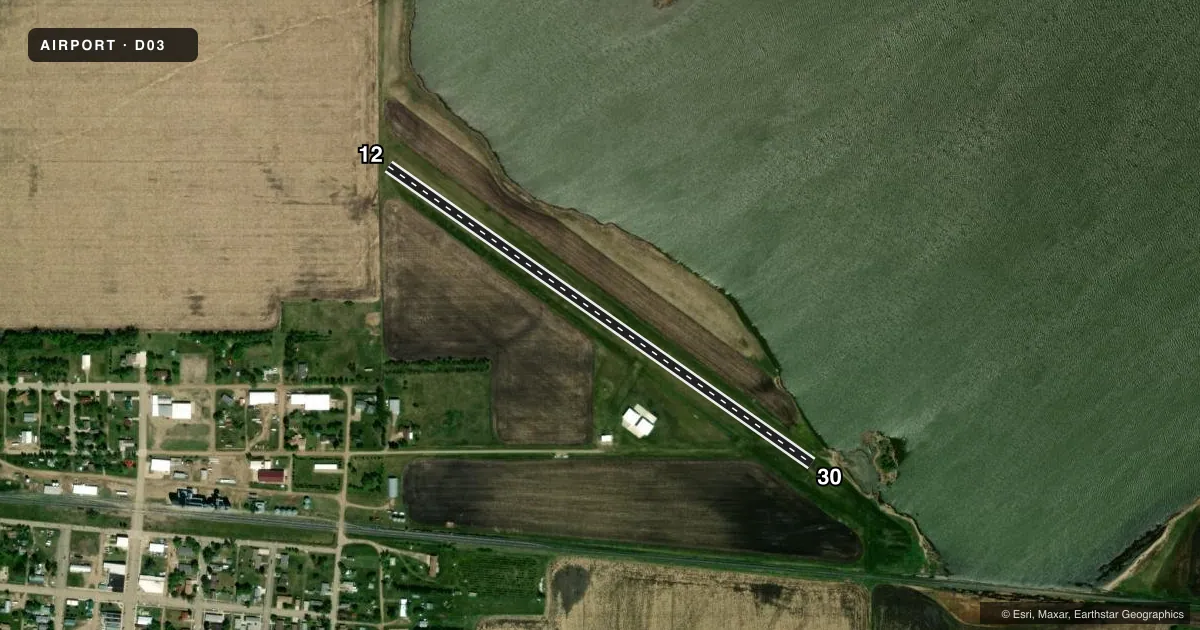
Runways & pattern
Full pagePattern entry · RWY 30
LEFT TRAFFICAirport sketch
Runways drawn to scale from FAA survey coordinates, rendered over satellite imagery. Not for navigation.
Approaches & charts
Services on the field
Fuel grades, oxygen, maintenance, ramp storage and lighting — as declared to the FAA by the airport operator.
Fuel & services
- Fuel
- Not available
- Other services
- INSTR
Ramp & ground
- Transient storage
- Tie-down
- Hangar
- Lighting schedule
- SEE RMK
- Wind indicator
- Lighted
- Segmented circle
- Yes
Fuel & FBOs
Cheapest 100LL and Jet A on the field and nearby. Always confirm with the FBO before taxi.
Airport notes
Surface conditions, obstructions, local procedures, lighting outages and other notes published with each FAA cycle.
General notes
- WATERFOWL AND DEER ON AND INVOF APRT.
- SNOW REMOVAL IRREGULAR. CONFIRM BEFORE USE - 701-830-2205/701-830-0292
- MULT 320 FT WND TURBINE TWRS NE, E, & SE OF RY FROM 1NM AND EXTENDING OUTWARD.
- FOR CD CTC MINNEAPOLIS ARTCC AT 651-463-5588.
- RWY 12 CULTIVATED FLD 50 FT FM THLD.
Lighting notes
- ACTVT LIRL RY 12/30 - CTAF.
Other notes
- MANAGERADTL PHONE 701-647-2324, OR MIKE HOLMGREN AT 701-830-0292.
- 12/30WHITE/BLACK CONES 400' APART ALONG RY EDGES.
VFR map & nearby airports
VFR sectional. Tap any ICAO chip to open that airport.
Key facts · D03
Answer card- ICAO
- D03
- Name
- KULM MUNI
- Location
- KULM, NORTH DAKOTA
- Elevation
- 1,959 ft MSL
- Traffic pattern altitude
- 2,959 ft MSL (1,000 AGL)
- Control tower
- Non-towered (use CTAF)
- Total runways
- 1
- Longest runway
- 12/30 · 2,800 ft
- Published ILS approaches
- 0
- Published frequencies
- 1
- Magnetic variation
- –
- Current flight rules
- VFR
- Current wind
- 350° at 10 kt
- Favored runway now
- RWY 30
KULM MUNI (D03) sits at Kulm, North Dakota. Field elevation is 1,959 ft MSL. The airport has one runway. Runway 12/30 is 2,800 ft of turf, so plan performance with that surface in mind. There is no control tower. CTAF is 122.9. Low intensity runway lights on 12/30 are activated by CTAF.
No ILS approaches are published here. Pattern altitude is not published in the facts, so use the standard 1,000 ft AGL for light piston operations unless the current FAA Chart Supplement says otherwise. The published remarks also note a cultivated field about 50 ft from the threshold of runway 12. White and black cones are spaced along the runway edges. That is a useful visual cue on rollout and during taxi.
This is a field where preflight planning matters. Waterfowl and deer are reported on and near the airport. Multiple 320-foot wind turbine towers sit northeast, east and southeast of the runway starting about 1 NM out. Snow removal is irregular, so confirm runway condition before you go. There are no on-field FBOs listed. Contact the airport operator directly before arrival. Call the field for current service details before arrival.