METAR & TAF Y63
Current METAR
Observed 18:35Z
KY63 271835Z AUTO 32007KT 10SM SCT023 29/22 A2982 RMK AO2 T02890221
- Wind
- 320° @ 7 kt
- Visibility
- 10 SM
- Temp / Dew
- 29°C / 22°C
- Altimeter
- 29.82 inHg
- Clouds
- SCT
- Density alt
- 3,299 ft
- Ceiling
- Unlimited
- Rules
- VFR
Airport info & contacts
Manager on record, flight service, ARTCC, attendance schedule and pattern altitude — published by the FAA and refreshed every 28 days.
Location
- From city
- 1 NM SW
- VFR sectional
- TWIN CITIES
- ARTCC
- ZMP · MINNEAPOLIS
- NOTAM facility
- Y63 (NOTAM-D)
Airport manager
- Name
- JOE LARUE
- Phone
- 218-685-6594
- Address
- 1111 2ND ST SW, ELBOW LAKE MN 56531-4214
Flight service · Hours
- FSS PNM
- PRINCETON1-800-WX-BRIEF
- Attendance
- MON-FRI · 0700-1800
Frequencies
Tap any row to copy the frequency to your clipboard.
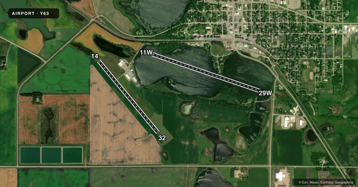
Runways & pattern
Full pagePattern entry · RWY 32
LEFT TRAFFIC| Runway | Heading (°M) | Length | Surface | Traffic |
|---|---|---|---|---|
| 11W/29W | 107° / 287° | 4,127 ft | WATER | 29W R |
| 14/32Favored | 138° / 319° | 3,401 ft | ASPH | Standard L |
Runway end performance
| End | TORA | TODA | ASDA | LDA | VGSI | Approach lights | Obstruction |
|---|---|---|---|---|---|---|---|
| 14 | — | — | — | — | PAPI 4-box left(3°) | — | — |
| 32 | — | — | — | — | PAPI 4-box left(3°) | — | — |
Declared distances in feet. TORA = takeoff run available, TODA = takeoff distance, ASDA = accelerate-stop, LDA = landing distance.
Airport sketch
Runways drawn to scale from FAA survey coordinates, rendered over satellite imagery. Not for navigation.
Approaches & charts
Services on the field
Fuel grades, oxygen, maintenance, ramp storage and lighting — as declared to the FAA by the airport operator.
Fuel & services
- Fuel
- 100LL
- Oxygen (bottled)
- Low pressure
- Oxygen (bulk)
- Not available
- Airframe repair
- Major
- Power plant repair
- Major
- Other services
- SALES
Ramp & ground
- Transient storage
- Tie-down
- Hangar
- Landing fee
- No fee published
- Customs
- Not available
- Lighting schedule
- SEE RMK
- Beacon schedule
- SS-SR
- Beacon
- White / Green (civil land)(WG)
- Wind indicator
- Lighted
- Segmented circle
- No
Fuel & FBOs
Cheapest 100LL and Jet A on the field and nearby. Always confirm with the FBO before taxi.
Airport notes
Surface conditions, obstructions, local procedures, lighting outages and other notes published with each FAA cycle.
General notes
- ULTRALIGHTS ON & INVOF ARPT.
- SEAPLANE OPS TO LAKE EAST OF ARPT MNT CTAF.
- FOR CD CTC MINNEAPOLIS ARTCC AT 651-463-5588.
Lighting notes
- ACTVT OR INCR INTST REIL RWY 14 & 32; PAPI RWY 14 & 32; MIRL RWY 14/32 - CTAF. MIRL RWY 14/32 PRESET LOW INTST.
Fuel notes
- 100LLFUEL AVBL H24 SELF SVC VIA CREDIT CARD.
Runway surface & condition
- 11W/29WCLSD SS-0700.
Other notes
- RWY 11W/29W 794 FT AGL.
VFR map & nearby airports
VFR sectional. Tap any ICAO chip to open that airport.
Key facts · Y63
Answer card- ICAO
- Y63
- Name
- ELBOW LAKE MUNI/PRIDE OF THE PRAIRIE
- Location
- ELBOW LAKE, MINNESOTA
- Elevation
- 1,205.8 ft MSL
- Traffic pattern altitude
- 2,205.8 ft MSL (1,000 AGL)
- Control tower
- Non-towered (use CTAF)
- Total runways
- 2
- Longest runway
- 11W/29W · 4,127 ft
- Published ILS approaches
- 0
- Published frequencies
- 1
- Magnetic variation
- 2°
- Current flight rules
- VFR
- Current wind
- 320° at 7 kt
- Favored runway now
- RWY 32
Y63 sits in Elbow Lake, Minnesota. Field elevation is 1,205.8 ft MSL. The airport has two runways. The longest is runway 11W/29W at 4,127 ft. Runway 14/32 is 3,401 ft asphalt. There is no control tower. CTAF is 122.9.
No ILS approaches are published here. Pattern altitude is not published in the facts, so check the current FAA Chart Supplement before arrival. Prairie Air is on the field. It carries 100LL. 100LL is also available 24 hours a day by self-service credit card. That is useful if you are planning an early departure or a late stop.
A few operational notes matter here. Ultralight aircraft operate on and near the airport. Seaplane operations occur on the lake east of the airport, so keep a sharp scan and monitor CTAF. Runway 11W/29W is a water runway. It is 794 ft above ground level. It is closed from sunset to 0700. Runways 14 and 32 have PAPI, runway end identifier lights and medium intensity runway lights. Those lights are controlled on CTAF and are preset to low intensity. If you need clearance delivery, Minneapolis ARTCC can be reached at 651-463-5588.