METAR & TAF KFFM
Current METAR
Observed 13:35Z
KFFM 271335Z AUTO 29006KT 6SM BR CLR 21/19 A2979 RMK AO2
- Wind
- 290° @ 6 kt
- Visibility
- 6 SM
- Temp / Dew
- 21°C / 19°C
- Altimeter
- 29.79 inHg
- Clouds
- CLR
- Density alt
- 2,347 ft
- Ceiling
- Unlimited
- Rules
- VFR
Airport info & contacts
Manager on record, flight service, ARTCC, attendance schedule and pattern altitude — published by the FAA and refreshed every 28 days.
Location
- From city
- 3 NM W
- VFR sectional
- TWIN CITIES
- ARTCC
- ZMP · MINNEAPOLIS
- NOTAM facility
- FFM (NOTAM-D)
Airport manager
- Name
- SKY CREW SERVICES LLC
- Phone
- 218-739-3733
- Address
- 4005 STATE HIGHWAY 210 W, FERGUS FALLS MN 56537-4005
Flight service · Hours
- FSS PNM
- PRINCETON1-800-WX-BRIEF
- Attendance
- MON-FRI · 0800-1700
- SAT · 0900-1400
Frequencies
Tap any row to copy the frequency to your clipboard.
Runways & pattern
Full pagePattern entry · RWY 31
LEFT TRAFFIC| Runway | Heading (°M) | Length | Surface | Traffic |
|---|---|---|---|---|
| 13/31Favored | 128° / 308° | 5,639 ft | ASPH | Standard L |
| 17/35 | 174° / 354° | 3,299 ft | ASPH | Standard L |
Runway end performance
| End | TORA | TODA | ASDA | LDA | VGSI | Approach lights | Obstruction |
|---|---|---|---|---|---|---|---|
| 13 | — | — | — | — | PAPI 4-box left(3°) | — | — |
| 31 | — | — | — | — | PAPI 4-box left(3°) | MALSR | — |
Declared distances in feet. TORA = takeoff run available, TODA = takeoff distance, ASDA = accelerate-stop, LDA = landing distance.
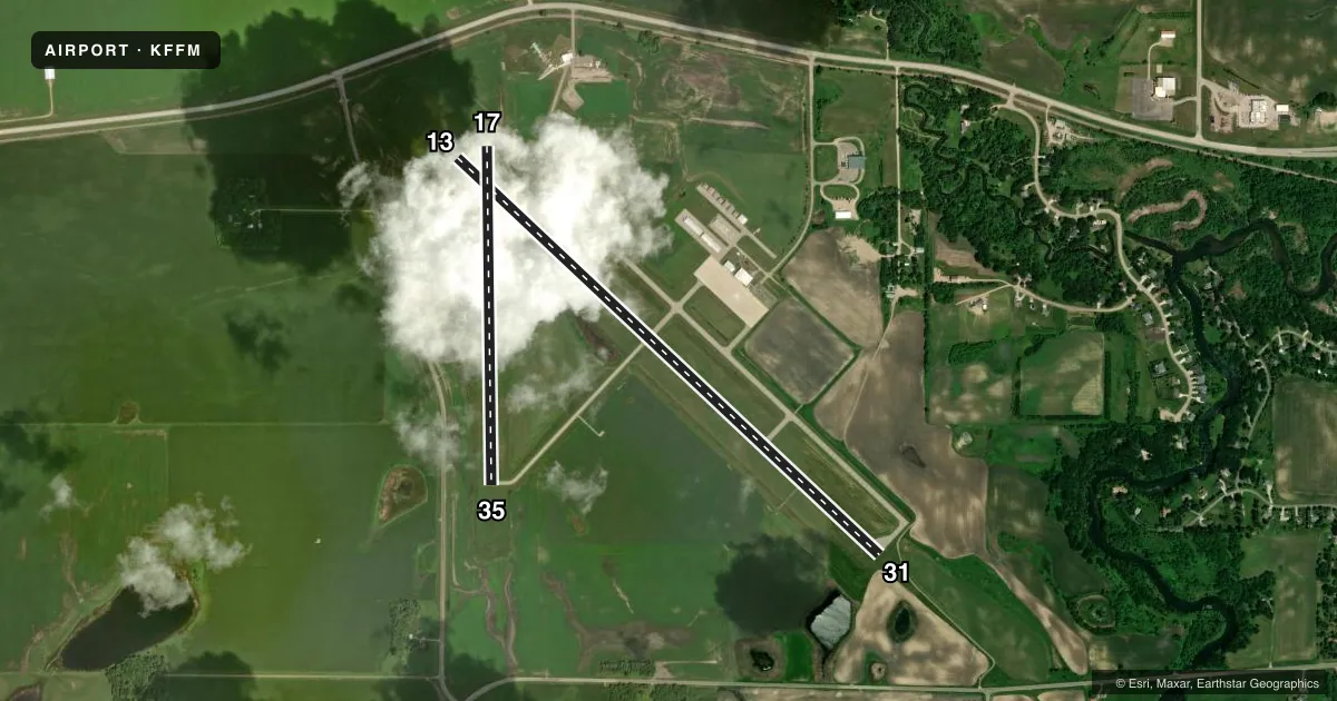
Airport sketch
Runways drawn to scale from FAA survey coordinates, rendered over satellite imagery. Not for navigation.
Approaches & charts
ILS · 1
Services on the field
Fuel grades, oxygen, maintenance, ramp storage and lighting — as declared to the FAA by the airport operator.
Fuel & services
- Fuel
- 100LLA
- Oxygen (bottled)
- Not available
- Oxygen (bulk)
- Not available
- Airframe repair
- Minor
- Power plant repair
- Minor
- Other services
- AGRI,RNTL,SALES
Ramp & ground
- Transient storage
- Tie-down
- Hangar
- Landing fee
- No fee published
- Customs
- Not available
- Lighting schedule
- SEE RMK
- Beacon schedule
- SS-SR
- Beacon
- White / Green (civil land)(WG)
- Wind indicator
- Lighted
- Segmented circle
- No
Fuel & FBOs
Cheapest 100LL and Jet A on the field and nearby. Always confirm with the FBO before taxi.
Airport notes
Surface conditions, obstructions, local procedures, lighting outages and other notes published with each FAA cycle.
General notes
- DEER & WATERFOWL ON & INVOF ARPT.
- ULTRALIGHTS ON & INVOF ARPT. ULTRALIGHT PATTERN 1800 FT MSL.
- FOR CD IF UNA TO CTC ON FSS FREQ, CTC MINNEAPOLIS ARTCC AT 651-463-5588.
Lighting notes
- ACTVT MALSR RWY 31; REIL RWY 13 & 35; PAPI RWY 13 & 31; MIRL RWY 13/31 & 17/35 - CTAF.
Fuel notes
- 100LLFUEL AVBL H24 VIA CREDIT CARD.
Other notes
- 1FOR ATTENDANT AFT HRS CALL AMGR.
VFR map & nearby airports
VFR sectional. Tap any ICAO chip to open that airport.
Key facts · KFFM
Answer card- ICAO
- KFFM
- Name
- FERGUS FALLS RGNL
- Location
- FERGUS FALLS, MINNESOTA
- Elevation
- 1,182.4 ft MSL
- Traffic pattern altitude
- 2,182.4 ft MSL (1,000 AGL)
- Control tower
- Non-towered (use CTAF)
- Total runways
- 2
- Longest runway
- 13/31 · 5,639 ft
- Published ILS approaches
- 1
- Published frequencies
- 2
- Magnetic variation
- 5°
- Current flight rules
- VFR
- Current wind
- 290° at 6 kt
- Favored runway now
- RWY 31
Fergus Falls Rgnl is in Fergus Falls, Minnesota. The field elevation is 1,182.4 ft MSL. It has two asphalt runways. The longest is runway 13/31 at 5,639 ft. There is no control tower, so use CTAF 122.8 for local traffic calls. The airport has one ILS approach, published for runway 31. Pattern altitude is not published in the facts, so plan to verify the current traffic pattern in the FAA Chart Supplement before you go. For light piston traffic, a standard 1,000 ft AGL pattern is often used when no published value is available. Confirm before flight.
Sky Crew Services is on the field. It carries 100LL, Jet A and Jet A Prist. 100LL is available 24 hours a day by credit card. If you need an attendant after hours, call the airport manager. The lighting setup is useful at night. Runway 31 has medium intensity approach lighting with runway alignment indicator lights. Runways 13 and 35 have REILs. PAPI is installed on runways 13 and 31. Medium intensity runway lights are installed on both runways.
First-time pilots should also plan for wildlife. Deer and waterfowl are reported on and near the airport. Ultralight traffic also operates in the area. Their pattern altitude is 1,800 ft MSL. If you need clearance delivery and cannot reach flight service, contact Minneapolis ARTCC at 651-463-5588.