METAR & TAF KHCD
Current METAR
Observed 17:35Z
KHCD 151735Z AUTO 26007G10KT 10SM SCT080 SCT100 22/05 A2990 RMK AO2 T02230051
- Wind
- 260° @ 7G10 kt
- Visibility
- 10 SM
- Temp / Dew
- 22°C / 5°C
- Altimeter
- 29.90 inHg
- Clouds
- SCT
- Density alt
- 2,182 ft
- Ceiling
- Unlimited
- Rules
- VFR
Airport info & contacts
Manager on record, flight service, ARTCC, attendance schedule and pattern altitude — published by the FAA and refreshed every 28 days.
Location
- From city
- 2 NM S
- VFR sectional
- TWIN CITIES
- ARTCC
- ZMP · MINNEAPOLIS
- NOTAM facility
- HCD (NOTAM-D)
Airport manager
- Name
- DONOVAN SCHUETTE
- Phone
- 320-234-4473
- Address
- 1400 ADAMS ST SE, HUTCHINSON MN 55350-7010
Flight service · Hours
- FSS PNM
- PRINCETON1-800-WX-BRIEF
- Attendance
- MON-FRI · 0800-1700
Frequencies
Tap any row to copy the frequency to your clipboard.
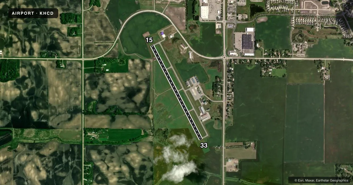
Runways & pattern
Full pagePattern entry · RWY 33
LEFT TRAFFICRunway end performance
| End | TORA | TODA | ASDA | LDA | VGSI | Approach lights | Obstruction |
|---|---|---|---|---|---|---|---|
| 15 | — | — | — | — | PAPI 4-box left(3°) | — | 7', crops, 276' from thr, 137' R of cntrln, slope 10 |
| 33 | — | — | — | — | PAPI 4-box left(3°) | — | 4', crops, 234' from thr, 152' R of cntrln, slope 8 |
Declared distances in feet. TORA = takeoff run available, TODA = takeoff distance, ASDA = accelerate-stop, LDA = landing distance.
Airport sketch
Runways drawn to scale from FAA survey coordinates, rendered over satellite imagery. Not for navigation.
Approaches & charts
Services on the field
Fuel grades, oxygen, maintenance, ramp storage and lighting — as declared to the FAA by the airport operator.
Fuel & services
- Fuel
- 100LLA
- Oxygen (bottled)
- Not available
- Oxygen (bulk)
- Not available
- Airframe repair
- Major
- Power plant repair
- Major
- Other services
- AGRI,SALES
Ramp & ground
- Transient storage
- Tie-down
- Hangar
- Landing fee
- No fee published
- Customs
- Not available
- Lighting schedule
- SEE RMK
- Beacon schedule
- SS-SR
- Beacon
- White / Green (civil land)(WG)
- Wind indicator
- Lighted
- Segmented circle
- Yes
Fuel & FBOs
Cheapest 100LL and Jet A on the field and nearby. Always confirm with the FBO before taxi.
Airport notes
Surface conditions, obstructions, local procedures, lighting outages and other notes published with each FAA cycle.
General notes
- GCO AVBL ON FREQ 121.725 THRU MINNEAPOLIS ARTCC & FLT SVCS.
- FOR CD IF UNA VIA GCO CTC MINNEAPOLIS ARTCC AT 651-463-5588.
Lighting notes
- ACTVT OR INCR INTST REIL RWY 15 & 33; PAPI RWY 15 & 33; MIRL RWY 15/33 - CTAF. MIRL RWY 15/33 PRESET LOW INTST.
Fuel notes
- 100LLAVBL H24 VIA CREDIT CARD.
- AAVBL H24 VIA CREDIT CARD.
Approach & departure obstructions
- 15RWY 15 HAS 7 FT CORN CROP 118 FT FM RWY END AND 163 FT R.
- 33RWY 33 HAS 7 FT CORN CROP 119 FT FM RWY END AND 194 FT R.
Other notes
- FOR TSNT HNGR AVBLTY CTC FBO AT 320-587-7615.
VFR map & nearby airports
VFR sectional. Tap any ICAO chip to open that airport.
Key facts · KHCD
Answer card- ICAO
- KHCD
- Name
- HUTCHINSON MUNI/BUTLER FLD
- Location
- HUTCHINSON, MINNESOTA
- Elevation
- 1,062.3 ft MSL
- Traffic pattern altitude
- 2,062.3 ft MSL (1,000 AGL)
- Control tower
- Non-towered (use CTAF)
- Total runways
- 1
- Longest runway
- 15/33 · 4,000 ft
- Published ILS approaches
- 0
- Published frequencies
- 2
- Magnetic variation
- 4°
- Current flight rules
- VFR
- Current wind
- 260° at 7 kt
- Favored runway now
- RWY 33
Hutchinson Muni/Butler Fld (KHCD) sits in Hutchinson, Minnesota. Field elevation is 1,062.3 ft MSL. The airport has one runway. Runway 15/33 is 4,000 ft of asphalt. There is no control tower. CTAF and UNICOM are both 122.8. No ILS approaches are published here.
Pattern altitude is not published. Use the standard 1,000 ft AGL for light piston traffic unless the current Chart Supplement says otherwise. The field has one on-field FBO listed as Hutchinson Municipal Airport. It carries 100LL and Jet A. Both fuels are available 24 hours a day by credit card. That is useful for late arrivals or early departures.
A few operational items matter here. Runway end identifier lights, PAPI and medium intensity runway lights on 15/33 can be activated or brightened on CTAF. The runway lights are preset to low intensity. Watch the published obstructions near both runway ends. There is a 7-foot corn crop close off the departure end of Runway 33. Runway 15 has a similar crop near its end. This is a field where a quick look at the current Chart Supplement and a normal farm-country scan on short final are both smart moves.