METAR & TAF KCFE
Current METAR
Observed 05:15Z
KCFE 270515Z AUTO 00000KT 10SM CLR 26/26 A2976 RMK AO2
- Wind
- 000° @ 0 kt
- Visibility
- 10 SM
- Temp / Dew
- 26°C / 26°C
- Altimeter
- 29.76 inHg
- Clouds
- CLR
- Density alt
- 2,718 ft
- Ceiling
- Unlimited
- Rules
- VFR
Airport info & contacts
Manager on record, flight service, ARTCC, attendance schedule and pattern altitude — published by the FAA and refreshed every 28 days.
Location
- From city
- 2 NM SE
- VFR sectional
- TWIN CITIES
- ARTCC
- ZMP · MINNEAPOLIS
- NOTAM facility
- CFE (NOTAM-D)
Airport manager
- Name
- CHRIS FREDRICK
- Phone
- 763-682-0296
- Address
- 212 CENTRAL AVE, BUFFALO MN 55313-1699
Flight service · Hours
- FSS PNM
- PRINCETON1-800-WX-BRIEF
- Attendance
- DAWN-DUSK
Frequencies
Tap any row to copy the frequency to your clipboard.
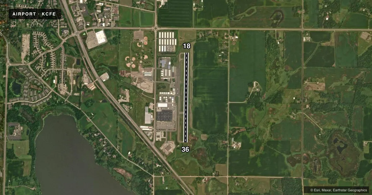
Runways & pattern
Full pagePattern entry · RWY 18
LEFT TRAFFICRunway end performance
| End | TORA | TODA | ASDA | LDA | VGSI | Approach lights | Obstruction |
|---|---|---|---|---|---|---|---|
| 18 | — | — | — | — | PAPI 2-box left(3.2°) | — | 73', trees, 1625' from thr, 326' R of cntrln, slope 19 |
| 36 | — | — | — | — | PAPI 2-box left(3°) | — | — |
Declared distances in feet. TORA = takeoff run available, TODA = takeoff distance, ASDA = accelerate-stop, LDA = landing distance.
Airport sketch
Runways drawn to scale from FAA survey coordinates, rendered over satellite imagery. Not for navigation.
Approaches & charts
Services on the field
Fuel grades, oxygen, maintenance, ramp storage and lighting — as declared to the FAA by the airport operator.
Fuel & services
- Fuel
- 100LL
- Oxygen (bottled)
- Not available
- Oxygen (bulk)
- Not available
- Airframe repair
- Major
- Power plant repair
- Major
- Other services
- AVNCS,SALES
Ramp & ground
- Transient storage
- Tie-down
- Landing fee
- No fee published
- Customs
- Not available
- Lighting schedule
- SEE RMK
- Beacon schedule
- SS-SR
- Beacon
- White / Green (civil land)(WG)
- Wind indicator
- Lighted
- Segmented circle
- No
Fuel & FBOs
Cheapest 100LL and Jet A on the field and nearby. Always confirm with the FBO before taxi.
Airport notes
Surface conditions, obstructions, local procedures, lighting outages and other notes published with each FAA cycle.
General notes
- ULTRALIGHT TFC ON & INVOF ARPT.
- GCO AVBL ON FREQ 121.725 THRU MINNEAPOLIS APCH & FSS.
- FOR CD CTC MINNEAPOLIS APCH AT 612-713-4016.
Lighting notes
- ACTVT REIL RWY 18 & 36; PAPI RWY 18 & 36; MIRL RWY 18/36 - CTAF. MIRL RWY 18/36 PRESET ON LOW INTST SS-SR, TO INCR INTST & ACTVT - CTAF.
Fuel notes
- 100LLFUEL AVAIL 24 HRS W CREDIT CARD.
Other notes
- MANAGERCHRIS.FREDRICK@CI.BUFFALO.MN.US.
VFR map & nearby airports
VFR sectional. Tap any ICAO chip to open that airport.
Key facts · KCFE
Answer card- ICAO
- KCFE
- Name
- BUFFALO MUNI
- Location
- BUFFALO, MINNESOTA
- Elevation
- 967.7 ft MSL
- Traffic pattern altitude
- 1,967.7 ft MSL (1,000 AGL)
- Control tower
- Non-towered (use CTAF)
- Total runways
- 1
- Longest runway
- 18/36 · 3,200 ft
- Published ILS approaches
- 0
- Published frequencies
- 4
- Magnetic variation
- 1°
- Current flight rules
- VFR
- Current wind
- 000° at 0 kt
- Favored runway now
- –
Buffalo Muni sits in Buffalo, Minnesota. The field elevation is 967.7 ft MSL. It has one runway. Runway 18/36 is 3,200 ft of asphalt, which is the longest runway on the field. There is no control tower. The published pattern altitude is not listed, so use the standard 1,000 ft AGL unless ATC or the current Chart Supplement says otherwise.
No ILS approaches are published here. The airport uses CTAF 122.8 and UNICOM 122.8. Minneapolis Approach also serves the field on 126.5 and 335.65. Published remarks say the runway lights on 18/36 are medium intensity and controlled by CTAF. They start at low intensity from sunset to sunrise. The runway end identifier lights and PAPI are installed on both ends. Fuel is available 24 hours with credit card. Buffalo Municipal Airport is the on-field FBO. It carries 100LL.
For a first-time arrival, the main things to plan for are the non-towered traffic flow, the ultralight traffic in the area and the lighting setup if you are arriving near dusk or after dark. The airport manager is listed in the Chart Supplement if you need the latest local details before you go.