METAR & TAF KGYL
Current METAR
Observed 22:55Z
KGYL 272255Z AUTO 30007KT 10SM CLR 31/24 A2975 RMK AO2 T03110235
- Wind
- 300° @ 7 kt
- Visibility
- 10 SM
- Temp / Dew
- 31°C / 24°C
- Altimeter
- 29.75 inHg
- Clouds
- CLR
- Density alt
- 3,362 ft
- Ceiling
- Unlimited
- Rules
- VFR
Airport info & contacts
Manager on record, flight service, ARTCC, attendance schedule and pattern altitude — published by the FAA and refreshed every 28 days.
Location
- From city
- 3 NM SE
- VFR sectional
- TWIN CITIES
- ARTCC
- ZMP · MINNEAPOLIS
- NOTAM facility
- GYL (NOTAM-D)
Airport manager
- Name
- MARK LARSON
- Phone
- 320-864-5586
- Address
- 1107 11TH ST E STE 107, GLENCOE MN 55336-2327
Flight service · Hours
- FSS PNM
- PRINCETON1-800-WX-BRIEF
- Attendance
- Unattended
Frequencies
Tap any row to copy the frequency to your clipboard.
Runways & pattern
Full pagePattern entry · RWY 31
LEFT TRAFFICRunway end performance
| End | TORA | TODA | ASDA | LDA | VGSI | Approach lights | Obstruction |
|---|---|---|---|---|---|---|---|
| 13 | — | — | — | — | PAPI 4-box left(3°) | — | — |
| 31 | — | — | — | — | PAPI 4-box left(3°) | — | — |
Declared distances in feet. TORA = takeoff run available, TODA = takeoff distance, ASDA = accelerate-stop, LDA = landing distance.
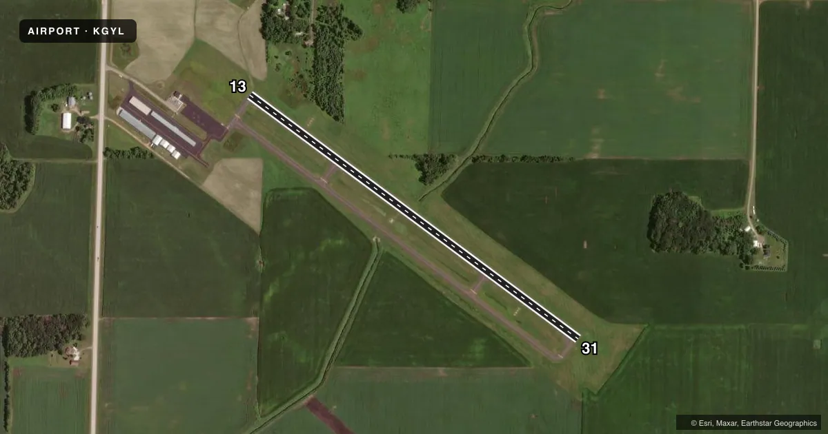
Airport sketch
Runways drawn to scale from FAA survey coordinates, rendered over satellite imagery. Not for navigation.
Approaches & charts
Services on the field
Fuel grades, oxygen, maintenance, ramp storage and lighting — as declared to the FAA by the airport operator.
Fuel & services
- Fuel
- 100LL
- Oxygen (bottled)
- Not available
- Oxygen (bulk)
- Not available
- Airframe repair
- Not available
- Power plant repair
- Not available
Ramp & ground
- Transient storage
- Tie-down
- Landing fee
- No fee published
- Customs
- Not available
- Lighting schedule
- SEE RMK
- Beacon schedule
- SS-SR
- Beacon
- White / Green (civil land)(WG)
- Wind indicator
- Lighted
- Segmented circle
- No
Fuel & FBOs
Cheapest 100LL and Jet A on the field and nearby. Always confirm with the FBO before taxi.
Airport notes
Surface conditions, obstructions, local procedures, lighting outages and other notes published with each FAA cycle.
General notes
- DEER ON & INVOF ARPT.
- ULTRALIGHT ACT ON & INVOF ARPT.
- FOR CD CTC MINNEAPOLIS APCH AT 612-713-4016.
Lighting notes
- ACTVT OR INCR INTST REIL RWY 13 & 31; PAPI RWY 13 & 31; MIRL RWY 13/31 - CTAF. MIRL RWY 13/31 PRESET LOW INTST.
Fuel notes
- 100LLFUEL AVBL H24 VIA CREDIT CARD.
Approach & departure obstructions
- 133 FT POLE, 0 FT DIST, 225 FT L.
VFR map & nearby airports
VFR sectional. Tap any ICAO chip to open that airport.
Key facts · KGYL
Answer card- ICAO
- KGYL
- Name
- GLENCOE MUNI
- Location
- GLENCOE, MINNESOTA
- Elevation
- 992.5 ft MSL
- Traffic pattern altitude
- 1,992.5 ft MSL (1,000 AGL)
- Control tower
- Non-towered (use CTAF)
- Total runways
- 1
- Longest runway
- 13/31 · 3,300 ft
- Published ILS approaches
- 0
- Published frequencies
- 4
- Magnetic variation
- 3°
- Current flight rules
- VFR
- Current wind
- 300° at 7 kt
- Favored runway now
- RWY 31
Glencoe Muni sits in Glencoe, Minnesota. The field elevation is 992.5 ft MSL. It has one runway, 13/31, which is 3,300 ft long. There is no control tower. Pattern altitude is not published, so use standard 1,000 ft AGL for light piston operations unless the current Chart Supplement says otherwise.
No ILS approaches are published here. The airport uses CTAF 122.8 and UNICOM 122.8. Minneapolis Approach is listed on 134.7 and 284.7. For clearance delivery, the published remark says to contact Minneapolis Approach at 612-726-9086. The on-field FBO is Glencoe Municipal Airport. It carries AVGAS 100LL. 100LL is available 24 hours a day via credit card.
A few operational items matter here. Deer are reported on and near the airport. Ultralight activity also occurs on and in the vicinity of the field. Runway end identifier lights on 13 and 31 can be activated or increased in intensity. The PAPI on both runway ends is operational. The medium intensity runway lights are on 13 and 31. There is also a published obstruction near runway 13. A 3-foot pole is located 225 feet left of the runway end. If you are new to the airport, brief the runway environment before arrival and keep a sharp lookout on taxi and final.