METAR & TAF KPEX
Current METAR
Observed 17:15Z
KPEX 271715Z AUTO 29011KT 10SM CLR 31/22 A2979 RMK AO2
- Wind
- 290° @ 11 kt
- Visibility
- 10 SM
- Temp / Dew
- 31°C / 22°C
- Altimeter
- 29.79 inHg
- Clouds
- CLR
- Density alt
- 3,548 ft
- Ceiling
- Unlimited
- Rules
- VFR
Airport info & contacts
Manager on record, flight service, ARTCC, attendance schedule and pattern altitude — published by the FAA and refreshed every 28 days.
Location
- From city
- 1 NM SW
- VFR sectional
- TWIN CITIES
- ARTCC
- ZMP · MINNEAPOLIS
- NOTAM facility
- PEX (NOTAM-D)
Airport manager
- Name
- RON MERGEN
- Phone
- 320-243-3714
- Address
- 221 WASHBURNE AVE, PAYNESVILLE MN 56362-1642
Flight service · Hours
- FSS PNM
- PRINCETON1-800-WX-BRIEF
- Attendance
- Unattended
Frequencies
Tap any row to copy the frequency to your clipboard.
Runways & pattern
Full pagePattern entry · RWY 29
LEFT TRAFFICRunway end performance
| End | TORA | TODA | ASDA | LDA | VGSI | Approach lights | Obstruction |
|---|---|---|---|---|---|---|---|
| 11 | — | — | — | — | PAPI 4-box left(3°) | — | — |
| 29 | — | — | — | — | PAPI 4-box left(3°) | — | — |
Declared distances in feet. TORA = takeoff run available, TODA = takeoff distance, ASDA = accelerate-stop, LDA = landing distance.
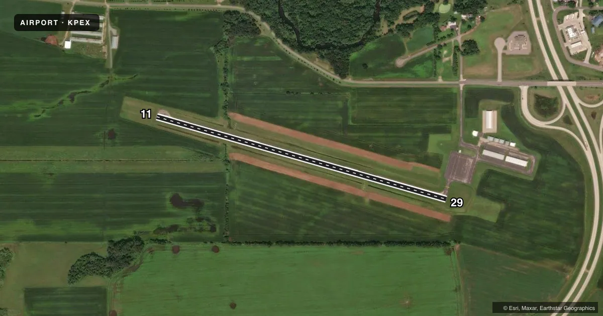
Airport sketch
Runways drawn to scale from FAA survey coordinates, rendered over satellite imagery. Not for navigation.
Approaches & charts
Services on the field
Fuel grades, oxygen, maintenance, ramp storage and lighting — as declared to the FAA by the airport operator.
Fuel & services
- Fuel
- 100LL
- Oxygen (bottled)
- Not available
- Oxygen (bulk)
- Not available
- Airframe repair
- Not available
- Power plant repair
- Not available
- Other services
- RNTL,SALES
Ramp & ground
- Transient storage
- Tie-down
- Landing fee
- No fee published
- Lighting schedule
- SEE RMK
- Wind indicator
- Lighted
- Segmented circle
- No
Fuel & FBOs
Cheapest 100LL and Jet A on the field and nearby. Always confirm with the FBO before taxi.
Airport notes
Surface conditions, obstructions, local procedures, lighting outages and other notes published with each FAA cycle.
General notes
- FOR CD CTC MINNEAPOLIS ARTCC AT 651-463-5588.
Lighting notes
- ACTVT OR INCR INTST REIL RWY 11 & 29; PAPI RWY 11 & 29; MIRL RWY 11/29 - CTAF. MIRL RWY 11/29 PRESET LOW INTST.
Fuel notes
- 100LLFUEL AVBL H24 VIA CREDIT CARD.
Other notes
- SEE ASP CASE 99-AGL-1410-NRA.
VFR map & nearby airports
VFR sectional. Tap any ICAO chip to open that airport.
Key facts · KPEX
Answer card- ICAO
- KPEX
- Name
- PAYNESVILLE MUNI
- Location
- PAYNESVILLE, MINNESOTA
- Elevation
- 1,182.7 ft MSL
- Traffic pattern altitude
- 2,182.7 ft MSL (1,000 AGL)
- Control tower
- Non-towered (use CTAF)
- Total runways
- 1
- Longest runway
- 11/29 · 3,302 ft
- Published ILS approaches
- 0
- Published frequencies
- 1
- Magnetic variation
- 1°
- Current flight rules
- VFR
- Current wind
- 290° at 11 kt
- Favored runway now
- RWY 29
Paynesville Muni sits in Paynesville, Minnesota. Field elevation is 1,182.7 ft MSL. The airport has one runway. Runway 11/29 is 3,302 ft long with an asphalt surface. There is no control tower. CTAF is 122.9. No ILS approaches are published here.
The published pattern altitude is not listed. Use the standard 1,000 ft AGL pattern unless the current Chart Supplement says otherwise. That puts the light-aircraft pattern at about 2,182.7 ft MSL based on the field elevation. Runway lighting is pilot-controlled on CTAF. The runway end identifier lights can be active or brighter than expected. PAPI is installed on both runway ends. Fuel is available 24 hours a day by credit card. There are no on-field FBOs listed. Plan on handling services directly with the airport or a local provider if you need anything beyond self-serve fuel.
For departure planning, clearance delivery is handled through Minneapolis ARTCC at 651-463-5588. The field is not towered, so expect self-announce traffic on CTAF. Verify the current Chart Supplement for any additional remarks before you go. With a single 3,302 ft runway and no published ILS, this is a simple field, but you still want to check runway condition, winds and density altitude before committing.