METAR & TAF D39
Current METAR
Observed 23:55Z
KD39 272355Z AUTO 29007KT 10SM SCT110 32/22 A2979 RMK AO2 T03150219 10329 20309
- Wind
- 290° @ 7 kt
- Visibility
- 10 SM
- Temp / Dew
- 32°C / 22°C
- Altimeter
- 29.79 inHg
- Clouds
- SCT
- Density alt
- 3,742 ft
- Ceiling
- Unlimited
- Rules
- VFR
Airport info & contacts
Manager on record, flight service, ARTCC, attendance schedule and pattern altitude — published by the FAA and refreshed every 28 days.
Location
- From city
- 2 NM SE
- VFR sectional
- TWIN CITIES
- Pattern altitude
- 800 ft AGL · 2,042 ft MSL
- ARTCC
- ZMP · MINNEAPOLIS
- NOTAM facility
- PNM (NOTAM-D)
Airport manager
- Name
- VICKI WILLER
- Phone
- 320-352-2203
- Address
- 320 OAK ST. S, SAUK CENTRE MN 56378
Flight service · Hours
- FSS PNM
- PRINCETON1-800-WX-BRIEF
- Attendance
- MON-FRI · 0800-1700
Frequencies
Tap any row to copy the frequency to your clipboard.
Runways & pattern
Full pagePattern entry · RWY 26
LEFT TRAFFIC| Runway | Heading (°M) | Length | Surface | Traffic |
|---|---|---|---|---|
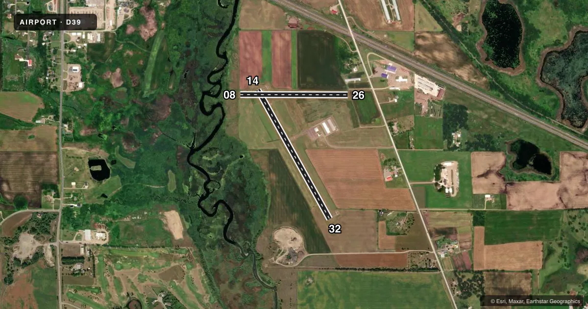
| 14/32 | 148° / 328° | 3,296 ft | ASPH | Standard L |
| 08/26Favored | 88° / 268° | 2,404 ft | TURF | Standard L |
Runway end performance
| End | TORA | TODA | ASDA | LDA | VGSI | Approach lights | Obstruction |
|---|---|---|---|---|---|---|---|
| 14 | — | — | — | — | PAPI 4-box left(3°) | — | — |
| 32 | — | — | — | — | PAPI 4-box left(3°) | — | — |
| 08 | — | — | — | — | — | — | 6', brush, 31' from thr, 112' R of cntrln, slope 5 |
| 26 | — | — | — | — | — | — | 19', road, 62' from thr, 123' R of cntrln, slope 3 |
Declared distances in feet. TORA = takeoff run available, TODA = takeoff distance, ASDA = accelerate-stop, LDA = landing distance.
Airport sketch
Runways drawn to scale from FAA survey coordinates, rendered over satellite imagery. Not for navigation.
Approaches & charts
Services on the field
Fuel grades, oxygen, maintenance, ramp storage and lighting — as declared to the FAA by the airport operator.
Fuel & services
- Fuel
- 100LL
- Oxygen (bottled)
- Not available
- Oxygen (bulk)
- Not available
- Airframe repair
- Major
- Power plant repair
- Minor
- Other services
- AGRI,SALES
Ramp & ground
- Transient storage
- Tie-down
- Hangar
- Landing fee
- No fee published
- Lighting schedule
- SEE RMK
- Beacon schedule
- SS-SR
- Beacon
- White / Green (civil land)(WG)
- Wind indicator
- Lighted
- Segmented circle
- No
Fuel & FBOs
Cheapest 100LL and Jet A on the field and nearby. Always confirm with the FBO before taxi.
Airport notes
Surface conditions, obstructions, local procedures, lighting outages and other notes published with each FAA cycle.
General notes
- FOR CD CTC MINNEAPOLIS ARTCC AT 651-463-5588.
Lighting notes
- RWY 14/32 MIRL PRESET TO LOW; TO INCR INTSTY AND ACTVT REIL RWY 14 & RWY 32; PAPI RWY 14 & RWY 32 - CTAF.
Fuel notes
- 100LLFUEL AVBL 24 HRS WITH CREDIT CARD.
Runway surface & condition
- 08/26RY 08/26 NOT PLOWED WINTER MONTHS.
Approach & departure obstructions
- 08RY 08 /26 MKD WITH YELLOW CONES.
VFR map & nearby airports
VFR sectional. Tap any ICAO chip to open that airport.
Key facts · D39
Answer card- ICAO
- D39
- Name
- SAUK CENTRE MUNI
- Location
- SAUK CENTRE, MINNESOTA
- Elevation
- 1,242.3 ft MSL
- Traffic pattern altitude
- 2,042.3 ft MSL (800 AGL)
- Control tower
- Non-towered (use CTAF)
- Total runways
- 2
- Longest runway
- 14/32 · 3,296 ft
- Published ILS approaches
- 0
- Published frequencies
- 1
- Magnetic variation
- 3°
- Current flight rules
- VFR
- Current wind
- 290° at 7 kt
- Favored runway now
- RWY 26
Sauk Centre Muni Airport (D39) sits in Sauk Centre, Minnesota. Field elevation is 1,242.3 ft MSL. The airport has two runways. The longest is runway 14/32 at 3,296 ft. There is no control tower. CTAF is 122.9. Pattern altitude is 800 ft AGL, which is 2,042.3 ft MSL.
Runway 14/32 is asphalt. Runway 08/26 is turf and is marked with yellow cones. The turf runway is not plowed during winter months. No ILS approaches are published here. Runway 14/32 has medium intensity lights that are preset to low. Use CTAF to raise the lights and to activate the runway end identifier lights. Precision approach path indicators are available for runway 14 and runway 32 on CTAF.
The on-field FBO is Sauk Centre Municipal Airport. It carries 100LL. Fuel is available 24 hours with a credit card. For clearance delivery, Minneapolis ARTCC can be reached at 651-463-5588. First-time arrivals should plan for an uncontrolled field with a single CTAF, then verify current runway condition before using the turf strip in winter. Check the current FAA Chart Supplement or call the airport operator if you need current operational details before departure.