METAR & TAF 8Y5
8Y5 does not publish a METAR.
Showing the nearest reporting station: KSAZ (STAPLES MUNI) · 16.6 NM away. Conditions at 8Y5 may differ.
METAR · KSAZ
Observed 20:55Z
KSAZ 272055Z AUTO 01007KT 9SM CLR 33/19 A2977 RMK AO2 T03270195 53004 $
- Wind
- 010° @ 7 kt
- Visibility
- 9 SM
- Temp / Dew
- 33°C / 19°C
- Altimeter
- 29.77 inHg
- Clouds
- CLR
- Density alt
- 3,968 ft
- Ceiling
- Unlimited
- Rules
- VFR
Airport info & contacts
Manager on record, flight service, ARTCC, attendance schedule and pattern altitude — published by the FAA and refreshed every 28 days.
Location
- From city
- 2 NM SE
- VFR sectional
- TWIN CITIES
- ARTCC
- ZMP · MINNEAPOLIS
- NOTAM facility
- PNM (NOTAM-D)
Airport manager
- Name
- JILL STALBERGER
- Phone
- 218-756-2125
- Address
- 202 MAIN ST W, CLARISSA MN 56440-4500
Flight service · Hours
- FSS PNM
- PRINCETON1-800-WX-BRIEF
- Attendance
- Unattended
Frequencies
Tap any row to copy the frequency to your clipboard.
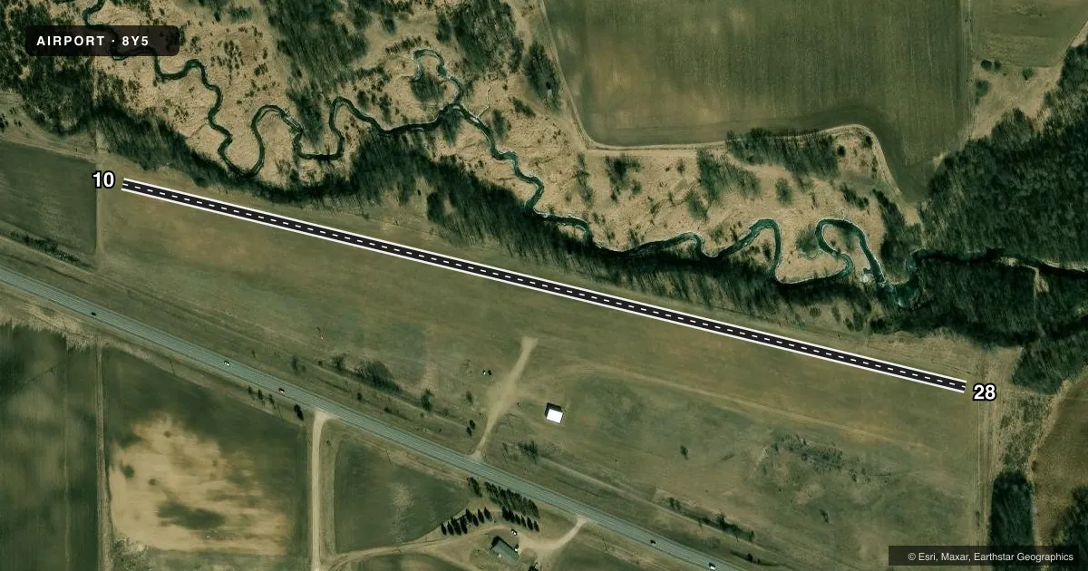
Runways & pattern
Full pagePattern entry · RWY 28
LEFT TRAFFICRunway end performance
| End | TORA | TODA | ASDA | LDA | VGSI | Approach lights | Obstruction |
|---|---|---|---|---|---|---|---|
| 10 | — | — | — | — | — | — | 8', crops, 42' from thr, 1' R of cntrln, slope 5 |
| 28 | — | — | — | — | — | — | 30', trees, 214' from thr, 144' R of cntrln, slope 7 |
Declared distances in feet. TORA = takeoff run available, TODA = takeoff distance, ASDA = accelerate-stop, LDA = landing distance.
Airport sketch
Runways drawn to scale from FAA survey coordinates, rendered over satellite imagery. Not for navigation.
Approaches & charts
Services on the field
Fuel grades, oxygen, maintenance, ramp storage and lighting — as declared to the FAA by the airport operator.
Fuel & services
- Fuel
- Not available
- Oxygen (bottled)
- Not available
- Oxygen (bulk)
- Not available
- Airframe repair
- Not available
- Power plant repair
- Not available
Ramp & ground
- Transient storage
- Tie-down
- Landing fee
- No fee published
- Wind indicator
- Yes
- Segmented circle
- No
Fuel & FBOs
Cheapest 100LL and Jet A on the field and nearby. Always confirm with the FBO before taxi.
Airport notes
Surface conditions, obstructions, local procedures, lighting outages and other notes published with each FAA cycle.
General notes
- FOR CD CTC MINNEAPOLIS ARTCC AT 651-463-5588.
Runway surface & condition
- 10/28NOT PLOWED WINTER MONTHS.
Approach & departure obstructions
- 10YELLOW CONES.
- 28YELLOW CONES.
VFR map & nearby airports
VFR sectional. Tap any ICAO chip to open that airport.
Key facts · 8Y5
Answer card- ICAO
- 8Y5
- Name
- CLARISSA MUNI
- Location
- CLARISSA, MINNESOTA
- Elevation
- 1,308 ft MSL
- Traffic pattern altitude
- 2,308 ft MSL (1,000 AGL)
- Control tower
- Non-towered (use CTAF)
- Total runways
- 1
- Longest runway
- 10/28 · 2,600 ft
- Published ILS approaches
- 0
- Published frequencies
- 1
- Magnetic variation
- 4°
- Current flight rules
- VFR
- Current wind
- 010° at 7 kt
- Favored runway now
- RWY 28
Clarissa Muni sits in Clarissa, Minnesota. Field elevation is 1,308 ft MSL. The airport has one runway. Runway 10/28 is 2,600 ft of turf, with magnetic headings 104° and 284°. It is not a towered field. CTAF is 122.9.
No ILS approaches are published here. Pattern altitude is not published, so use the standard 1,000 ft AGL for light piston operations unless the current FAA Chart Supplement says otherwise. That puts the traffic pattern at 2,308 ft MSL based on the field elevation. The published remarks matter here. Runway 10/28 is not plowed in winter. Runway 10 and Runway 28 are marked with yellow cones. That is useful to know before you plan a landing on turf.
There are no on-field FBOs listed. Contact the airport operator directly before arrival, or call the field on CTAF for current fuel or service availability. For clearance delivery, the FAA publishes a Minneapolis ARTCC contact number in the remarks. If you are filing IFR or need current operational details, verify everything in the current FAA Chart Supplement before departure.