METAR & TAF KJMR
Current METAR
Observed 23:15Z
KJMR 272315Z AUTO 07005KT 10SM SCT028 27/21 A2982 RMK AO2
- Wind
- 070° @ 5 kt
- Visibility
- 10 SM
- Temp / Dew
- 27°C / 21°C
- Altimeter
- 29.82 inHg
- Clouds
- SCT
- Density alt
- 2,845 ft
- Ceiling
- Unlimited
- Rules
- VFR
Airport info & contacts
Manager on record, flight service, ARTCC, attendance schedule and pattern altitude — published by the FAA and refreshed every 28 days.
Location
- From city
- 1 NM NE
- VFR sectional
- TWIN CITIES
- ARTCC
- ZMP · MINNEAPOLIS
- NOTAM facility
- JMR (NOTAM-D)
Airport manager
- Name
- TIM SEVCIK
- Phone
- 320-674-4997
- Address
- 101 LAKE STREET SOUTH, MORA MN 55051
Flight service · Hours
- FSS PNM
- PRINCETON1-800-WX-BRIEF
- Attendance
- Unattended
Frequencies
Tap any row to copy the frequency to your clipboard.
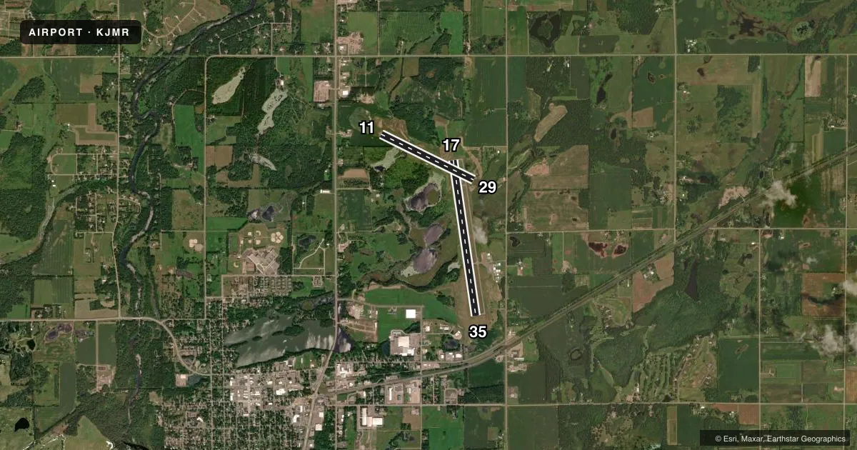
Runways & pattern
Full pagePattern entry · RWY 11
LEFT TRAFFIC| Runway | Heading (°M) | Length | Surface | Traffic |
|---|---|---|---|---|
| 17/35 | 172° / 352° | 4,794 ft | ASPH | Standard L |
| 11/29Favored | 116° / 296° | 3,152 ft | TURF | Standard L |
Runway end performance
| End | TORA | TODA | ASDA | LDA | VGSI | Approach lights | Obstruction |
|---|---|---|---|---|---|---|---|
| 17 | — | — | — | — | PAPI 4-box left(3°) | — | — |
| 35 | — | — | — | — | PAPI 4-box left(3°) | — | — |
Declared distances in feet. TORA = takeoff run available, TODA = takeoff distance, ASDA = accelerate-stop, LDA = landing distance.
Airport sketch
Runways drawn to scale from FAA survey coordinates, rendered over satellite imagery. Not for navigation.
Approaches & charts
Services on the field
Fuel grades, oxygen, maintenance, ramp storage and lighting — as declared to the FAA by the airport operator.
Fuel & services
- Fuel
- 100LLA
- Oxygen (bottled)
- Not available
- Oxygen (bulk)
- Not available
- Airframe repair
- Not available
- Power plant repair
- Not available
- Other services
- CHTR,SALES
Ramp & ground
- Transient storage
- Tie-down
- Landing fee
- No fee published
- Customs
- Not available
- Lighting schedule
- SEE RMK
- Beacon schedule
- SS-SR
- Beacon
- White / Green (civil land)(WG)
- Wind indicator
- Lighted
- Segmented circle
- No
Fuel & FBOs
Cheapest 100LL and Jet A on the field and nearby. Always confirm with the FBO before taxi.
Airport notes
Surface conditions, obstructions, local procedures, lighting outages and other notes published with each FAA cycle.
General notes
- WATERFOWL INVOF ARPT.
- ULTRALIGHTS ON & INVOF ARPT.
- FOR CD CTC MINNEAPOLIS ARTCC AT 651-463-5588.
Lighting notes
- ACTVT REIL RWY 17 & 35; PAPI RWY 17 & 35 - CTAF. MIRL RWY 17/35 PRESET TO LOW INTST; TO INCR INTST - CTAF.
Fuel notes
- 100LLFUEL AVBL H24 WITH CREDIT CARD.
Approach & departure obstructions
- 11MKD WITH YELLOW CONES.
- 29MKD WITH YELLOW CONES.
Other notes
- MANAGEREMAIL ADDRESS: JOE.KOHLGRAF@CITYOFMORA.COM (ALL LOWER CASE)
- 11/29GRVL PATCHES AND BARE SPOTS.
VFR map & nearby airports
VFR sectional. Tap any ICAO chip to open that airport.
Key facts · KJMR
Answer card- ICAO
- KJMR
- Name
- MORA MUNI
- Location
- MORA, MINNESOTA
- Elevation
- 1,032.8 ft MSL
- Traffic pattern altitude
- 2,032.8 ft MSL (1,000 AGL)
- Control tower
- Non-towered (use CTAF)
- Total runways
- 2
- Longest runway
- 17/35 · 4,794 ft
- Published ILS approaches
- 0
- Published frequencies
- 2
- Magnetic variation
- 0°
- Current flight rules
- VFR
- Current wind
- 070° at 5 kt
- Favored runway now
- RWY 11
Mora Muni sits in Mora, Minnesota. The field elevation is 1,032.8 ft MSL. It has two runways. The longest is 17/35 at 4,794 ft. There is no control tower. CTAF and UNICOM are both 122.8. No ILS approaches are published.
The pattern altitude is not published. Use the standard 1,000 ft AGL for light piston operations unless the current Chart Supplement says otherwise. That puts the pattern at about 2,033 ft MSL based on the field elevation, but verify before you fly. Runway 17/35 has REIL lighting. It also has PAPI. The medium intensity lights on 17/35 are preset to low. Use CTAF to increase intensity. Runway 11 has yellow cones. Runway 29 also has yellow cones. Runway 11/29 has gravel patches and bare spots, so expect a rougher turf surface there.
Mora Municipal Airport is on the field. It carries 100LL and Jet A. 100LL is available 24 hours with credit card. Ultralights operate on and near the airport. Waterfowl are also present in the vicinity. For clearance delivery, contact Minneapolis ARTCC at 651-463-5588. Pilots should plan for an uncontrolled field with mixed traffic, then brief the runway surface and lighting setup before arrival.