METAR & TAF M69
M69 does not publish a METAR.
Showing the nearest reporting station: KAIT (AITKIN MUNI/STEVE KURTZ FLD) · 12.1 NM away. Conditions at M69 may differ.
METAR · KAIT
Observed 05:15Z
KAIT 270515Z AUTO 19003KT 10SM CLR 26/23 A2973 RMK AO2 LTG DSNT N AND NE
- Wind
- 190° @ 3 kt
- Visibility
- 10 SM
- Temp / Dew
- 26°C / 23°C
- Altimeter
- 29.73 inHg
- Clouds
- CLR
- Density alt
- 3,140 ft
- Ceiling
- Unlimited
- Rules
- VFR
Airport info & contacts
Manager on record, flight service, ARTCC, attendance schedule and pattern altitude — published by the FAA and refreshed every 28 days.
Location
- From city
- 6 NM SE
- VFR sectional
- TWIN CITIES
- ARTCC
- ZMP · MINNEAPOLIS
- NOTAM facility
- PNM (NOTAM-D)
Airport manager
- Name
- DAVE RAMSAY
- Phone
- 952-831-6622
- Address
- 15269 CHARLSON ROAD, EDEN PRAIRIE MN 55347-3153
Flight service · Hours
- FSS PNM
- PRINCETON1-800-WX-BRIEF
- Attendance
- Unattended
Frequencies
Tap any row to copy the frequency to your clipboard.
Runways & pattern
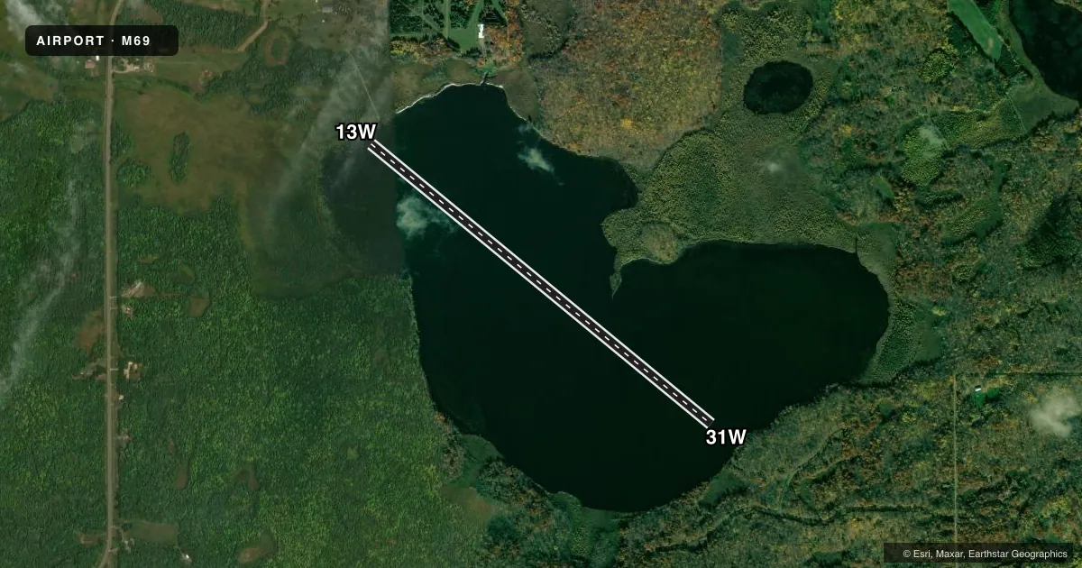
Full pagePattern entry · RWY 13W
LEFT TRAFFICAirport sketch
Runways drawn to scale from FAA survey coordinates, rendered over satellite imagery. Not for navigation.
Approaches & charts
Services on the field
Fuel grades, oxygen, maintenance, ramp storage and lighting — as declared to the FAA by the airport operator.
Fuel & services
- Fuel
- Not available
Ramp & ground
- Transient storage
- Tie-down
- Landing fee
- No fee published
- Wind indicator
- Yes
- Segmented circle
- No
Fuel & FBOs
Cheapest 100LL and Jet A on the field and nearby. Always confirm with the FBO before taxi.
Airport notes
Surface conditions, obstructions, local procedures, lighting outages and other notes published with each FAA cycle.
General notes
- FOR CD CTC MINNEAPOLIS ARTCC AT 651-463-5588.
Other notes
- WIND INDCR LCTD NORTH OF LAKE OBSC BY TREES.
- MANAGERARPT PHYS ADS: 27899 WAFFENSMITH RD, DEERWOOD, MN 56444.
VFR map & nearby airports
VFR sectional. Tap any ICAO chip to open that airport.
Key facts · M69
Answer card- ICAO
- M69
- Name
- BIRCH LAKE
- Location
- DEERWOOD, MINNESOTA
- Elevation
- 1,278 ft MSL
- Traffic pattern altitude
- 2,278 ft MSL (1,000 AGL)
- Control tower
- Non-towered (use CTAF)
- Total runways
- 1
- Longest runway
- 13W/31W · 5,283 ft
- Published ILS approaches
- 0
- Published frequencies
- 1
- Magnetic variation
- –
- Current flight rules
- VFR
- Current wind
- 190° at 3 kt
- Favored runway now
- RWY 13W
Birch Lake is in Deerwood, Minnesota. The field elevation is 1,278 ft MSL. It has one runway, a 5,283 ft water runway labeled 13W/31W. There is no control tower. CTAF is 122.9. No ILS approaches are published here.
Pattern altitude is not published. Use the standard 1,000 ft AGL pattern for light piston operations unless the current Chart Supplement says otherwise. The airport is in Type C airspace per the facts provided. If you are planning a first visit, pay attention to the wind indicator. It is north of the lake and can be obscured by trees. That can make the wind check less reliable from a distance.
No on-field FBOs are listed in the facts. Contact the airport operator directly or call the field on CTAF for current services before arrival. For clearance delivery, contact Minneapolis ARTCC at 651-463-5588. The airport physical address is 27899 Waffensmith Road, Deerwood, Minnesota 56444. Runway headings are listed as magnetic for the water runway, with 13W at 129.5 degrees and 31W at 309.5 degrees.