METAR & TAF KHZX
Current METAR
Observed 16:35Z
KHZX 271635Z AUTO 34008KT 10SM OVC017 26/21 A2975 RMK AO2
- Wind
- 340° @ 8 kt
- Visibility
- 10 SM
- Temp / Dew
- 26°C / 21°C
- Altimeter
- 29.75 inHg
- Clouds
- OVC
- Density alt
- 3,054 ft
- Ceiling
- 1,700 ft AGL
- Rules
- MVFR
Airport info & contacts
Manager on record, flight service, ARTCC, attendance schedule and pattern altitude — published by the FAA and refreshed every 28 days.
Location
- From city
- 1 NM N
- VFR sectional
- TWIN CITIES
- ARTCC
- ZMP · MINNEAPOLIS
- NOTAM facility
- HZX (NOTAM-D)
Airport manager
- Name
- JEROME CARR
- Phone
- (218) 768-2442
- Address
- 111 CENTER AVE E., BOX 100, MC GREGOR MN 55760
Flight service · Hours
- FSS PNM
- PRINCETON1-800-WX-BRIEF
- Attendance
- Unattended
Frequencies
Tap any row to copy the frequency to your clipboard.
Runways & pattern
Full pagePattern entry · RWY 32
LEFT TRAFFICRunway end performance
| End | TORA | TODA | ASDA | LDA | VGSI | Approach lights | Obstruction |
|---|---|---|---|---|---|---|---|
| 14 | — | — | — | — | VASI 2-box left(3°) | — | — |
| 32 | — | — | — | — | VASI 2-box right(3°) | — | 3', trees, 257' from thr, 5' R of cntrln, slope 19 |
Declared distances in feet. TORA = takeoff run available, TODA = takeoff distance, ASDA = accelerate-stop, LDA = landing distance.
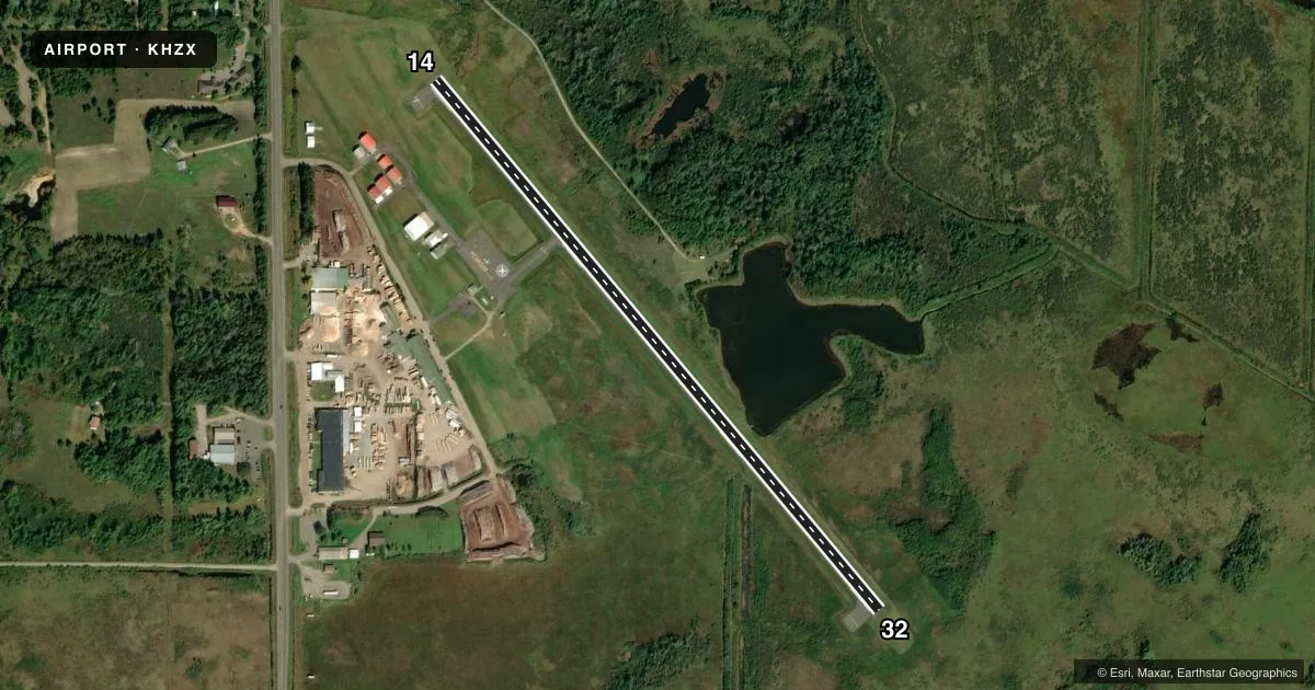
Airport sketch
Runways drawn to scale from FAA survey coordinates, rendered over satellite imagery. Not for navigation.
Approaches & charts
Services on the field
Fuel grades, oxygen, maintenance, ramp storage and lighting — as declared to the FAA by the airport operator.
Fuel & services
- Fuel
- 100LLMOGAS
- Oxygen (bottled)
- Not available
- Oxygen (bulk)
- Not available
- Airframe repair
- Not available
- Power plant repair
- Not available
Ramp & ground
- Transient storage
- Tie-down
- Landing fee
- No fee published
- Customs
- Not available
- Lighting schedule
- SEE RMK
- Beacon schedule
- SS-SR
- Beacon
- White / Green (civil land)(WG)
- Wind indicator
- Lighted
- Segmented circle
- Yes
Fuel & FBOs
Cheapest 100LL and Jet A on the field and nearby. Always confirm with the FBO before taxi.
Airport notes
Surface conditions, obstructions, local procedures, lighting outages and other notes published with each FAA cycle.
General notes
- ULTRALIGHTS ON AND INVOF AIRPORT.
- FOR CD CTC MINNEAPOLIS ARTCC AT 651-463-5588.
Lighting notes
- MIRL RY 14/32 PRESET TO LOW; TO INCR INTST & ACTVT VASI RY 14 & RY 32 - CTAF.
Fuel notes
- 100LL24 HOUR CREDIT CARD FUEL AVBL.
Other notes
- ESTAB PRIOR TO 1959.
VFR map & nearby airports
VFR sectional. Tap any ICAO chip to open that airport.
Key facts · KHZX
Answer card- ICAO
- KHZX
- Name
- ISEDOR IVERSON
- Location
- MC GREGOR, MINNESOTA
- Elevation
- 1,228.3 ft MSL
- Traffic pattern altitude
- 2,228.3 ft MSL (1,000 AGL)
- Control tower
- Non-towered (use CTAF)
- Total runways
- 1
- Longest runway
- 14/32 · 3,400 ft
- Published ILS approaches
- 0
- Published frequencies
- 1
- Magnetic variation
- 1°
- Current flight rules
- MVFR
- Current wind
- 340° at 8 kt
- Favored runway now
- RWY 32
Isedor Iverson Airport is in McGregor, Minnesota. The field elevation is 1,228.3 ft MSL. It has one runway. Runway 14/32 is 3,400 ft of asphalt. There is no control tower. CTAF is 122.9.
No ILS approaches are published here. Pattern altitude is not published in the facts, so use the standard 1,000 ft AGL pattern unless the current Chart Supplement says otherwise. The airport sits in a rural part of north-central Minnesota. Expect to plan for normal density altitude changes in warm weather because the field is already above 1,200 ft MSL.
Isedor Iverson Airport is the on-field FBO. It carries AVGAS 100LL and MOGAS. 24-hour credit card fuel is available. The published remarks also note that runway lights on 14/32 are preset to low. Use CTAF to increase intensity. The same CTAF call also activates the VASI on runway 14 and runway 32. Ultralights operate on and near the airport, so keep a sharp lookout in the pattern. For clearance delivery, contact Minneapolis ARTCC at 651-463-5588.