METAR & TAF KGPZ
Current METAR
Observed 08:56Z
KGPZ 260856Z AUTO 17005KT 2 1/2SM BR CLR 18/18 A2988 RMK AO2 SLP112 T01780178 58005 $
- Wind
- 170° @ 5 kt
- Visibility
- 0.5 SM
- Temp / Dew
- 18°C / 18°C
- Altimeter
- 29.88 inHg
- Clouds
- CLR
- Density alt
- 2,091 ft
- Ceiling
- Unlimited
- Rules
- LIFR
Airport info & contacts
Manager on record, flight service, ARTCC, attendance schedule and pattern altitude — published by the FAA and refreshed every 28 days.
Location
- From city
- 2 NM SE
- VFR sectional
- TWIN CITIES
- ARTCC
- ZMP · MINNEAPOLIS
- NOTAM facility
- GPZ (NOTAM-D)
Airport manager
- Name
- MATT WEGWERTH
- Phone
- 218-326-7625
- Address
- 420 N POKEGAMA AVE, GRAND RAPIDS MN 55744
Flight service · Hours
- FSS PNM
- PRINCETON1-800-WX-BRIEF
- Attendance
- APR-OCT · 0700-2100
- NOV-MAR · 0700-2000
Frequencies
Tap any row to copy the frequency to your clipboard.
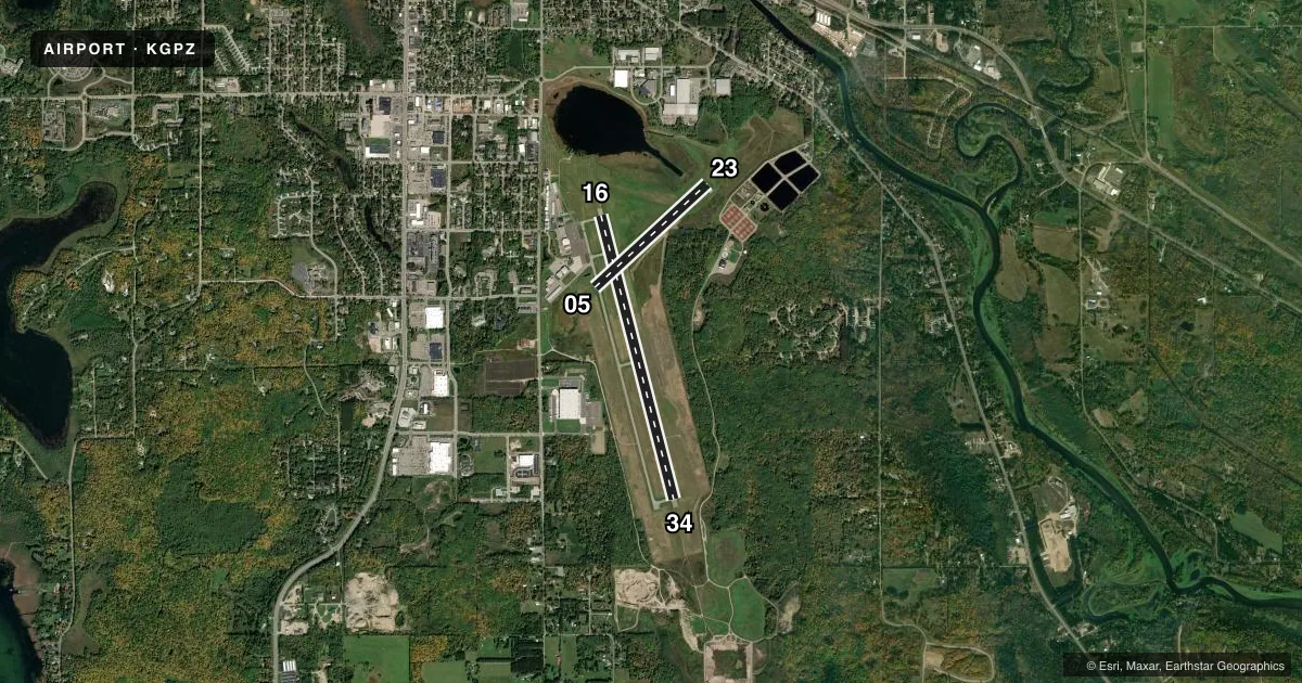
Runways & pattern
Full pagePattern entry · RWY 16
LEFT TRAFFIC| Runway | Heading (°M) | Length | Surface | Traffic |
|---|---|---|---|---|
| 16/34Favored | 164° / 344° | 5,756 ft | ASPH | Standard L |
| 05/23 | 45° / 225° | 3,000 ft | ASPH | Standard L |
Runway end performance
| End | TORA | TODA | ASDA | LDA | VGSI | Approach lights | Obstruction |
|---|---|---|---|---|---|---|---|
| 16 | — | — | — | — | PAPI 4-box right(3°) | — | — |
| 34 | — | — | — | — | PAPI 4-box left(3°) | MALSR | 37', brush, 1378' from thr, 562' R of cntrln, slope 31 |
| 05 | — | — | — | — | PAPI 4-box left(3.5°) | — | — |
| 23 | — | — | — | — | PAPI 4-box left(3°) | — | — |
Declared distances in feet. TORA = takeoff run available, TODA = takeoff distance, ASDA = accelerate-stop, LDA = landing distance.
Airport sketch
Runways drawn to scale from FAA survey coordinates, rendered over satellite imagery. Not for navigation.
Approaches & charts
ILS · 1
Services on the field
Fuel grades, oxygen, maintenance, ramp storage and lighting — as declared to the FAA by the airport operator.
Fuel & services
- Fuel
- 100LLA
- Oxygen (bottled)
- Not available
- Oxygen (bulk)
- Low pressure
- Airframe repair
- Major
- Power plant repair
- Major
- Other services
- AFRT,BCHGR,CHTR,INSTR,RNTL,SALES
Ramp & ground
- Transient storage
- Tie-down
- Hangar
- Landing fee
- No fee published
- Customs
- Not available
- Lighting schedule
- SEE RMK
- Beacon schedule
- SS-SR
- Beacon
- White / Green (civil land)(WG)
- Wind indicator
- Lighted
- Segmented circle
- Yes
Fuel & FBOs
Cheapest 100LL and Jet A on the field and nearby. Always confirm with the FBO before taxi.
Airport notes
Surface conditions, obstructions, local procedures, lighting outages and other notes published with each FAA cycle.
General notes
- LILY LAKE SPB OPS N OF ARPT; PPR RQR CTC - (218) 326-1226.
- DEER AND BIRDS ON & INVOF ARPT.
- FOR CD IF UNA TO CTC ON FSS FREQ, CTC MINNEAPOLIS ARTCC AT 651-463-5588.
Lighting notes
- ACTVT MALSR RWY 34; REIL RWY 05, 16, 23; PAPI RWY 05, 16, 23, 34; MIRL RWY 05/23; HIRL RWY 16/34 - CTAF.
Runway surface & condition
- 16/34228 FT PAVED AREA AT N END.
Approach & departure obstructions
- 34CALM WIND RWY.
- 05UNUSBL BYD 6 DEGS LEFT AND RIGHT OF CNTRLN.
Other notes
- MANAGERMWEGWERTH@CI.GRAND-RAPIDS.MN.US.
VFR map & nearby airports
VFR sectional. Tap any ICAO chip to open that airport.
Key facts · KGPZ
Answer card- ICAO
- KGPZ
- Name
- GRAND RAPIDS/ITASCA COUNTY-GORDON NEWSTROM FLD
- Location
- GRAND RAPIDS, MINNESOTA
- Elevation
- 1,355.7 ft MSL
- Traffic pattern altitude
- 2,355.7 ft MSL (1,000 AGL)
- Control tower
- Non-towered (use CTAF)
- Total runways
- 2
- Longest runway
- 16/34 · 5,756 ft
- Published ILS approaches
- 1
- Published frequencies
- 2
- Magnetic variation
- 2°
- Current flight rules
- LIFR
- Current wind
- 170° at 5 kt
- Favored runway now
- RWY 16
Grand Rapids/Itasca County-Gordon Newstrom Fld sits in Grand Rapids, Minnesota. Field elevation is 1,355.7 ft MSL. The airport has two asphalt runways. The longest is runway 16/34 at 5,756 ft. There is no control tower. CTAF and UNICOM are both 122.8. Pattern altitude is not published. Use the standard 1,000 ft AGL for light piston traffic unless local procedures say otherwise.
Runway 34 has the published ILS. The field also has lighting that supports night work. MALSR is activated for runway 34. Runway end identifier lights are installed on runways 05, 16 and 23. PAPI is installed on all runway ends. Runway 34 is listed as the calm wind runway. If you are new to the field, watch for deer and birds in the area. Runway 05 has a note on the visual glide slope indicator. It is unusable beyond 6 degrees left and right of centerline.
AirWays Aviation Center is on the field. It carries 100LL and Jet A with Prist. For clearance delivery, if you cannot reach flight service, contact Minneapolis ARTCC. The airport also notes seaplane activity north of the airport at Lily Lake. Prior permission is required. Check current airport procedures before arrival.