METAR & TAF 9Y0
9Y0 does not publish a METAR.
Showing the nearest reporting station: KFOZ (BIGFORK MUNI) · 16.2 NM away. Conditions at 9Y0 may differ.
METAR · KFOZ
Observed 22:55Z
KFOZ 272255Z AUTO VRB04KT 10SM CLR 27/20 A2980 RMK AO2 T02740203
- Wind
- VAR @ 4 kt
- Visibility
- 10 SM
- Temp / Dew
- 27°C / 20°C
- Altimeter
- 29.80 inHg
- Clouds
- CLR
- Density alt
- 3,290 ft
- Ceiling
- Unlimited
- Rules
- VFR
Airport info & contacts
Manager on record, flight service, ARTCC, attendance schedule and pattern altitude — published by the FAA and refreshed every 28 days.
Location
- From city
- 2 NM NW
- VFR sectional
- TWIN CITIES
- ARTCC
- ZMP · MINNEAPOLIS
- NOTAM facility
- PNM (NOTAM-D)
Airport manager
- Name
- KENNETH REICHERT
- Phone
- 218-244-6328
- Address
- 47703 NUTMEG RD, DEER RIVER MN 56636-2544
Flight service · Hours
- FSS PNM
- PRINCETON1-800-WX-BRIEF
- Attendance
- Unattended
Frequencies
Tap any row to copy the frequency to your clipboard.
Runways & pattern
Full pagePattern entry · RWY 07
LEFT TRAFFICRunway end performance
| End | TORA | TODA | ASDA | LDA | VGSI | Approach lights | Obstruction |
|---|---|---|---|---|---|---|---|
| 07 | — | — | — | — | — | — | 108', trees, 1720' from thr, 177' R of cntrln, slope 15 |
| 25 | — | — | — | — | — | — | 73', brush, 117' from thr, 127' R of cntrln, slope 1 |
Declared distances in feet. TORA = takeoff run available, TODA = takeoff distance, ASDA = accelerate-stop, LDA = landing distance.
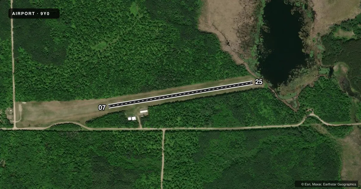
Airport sketch
Runways drawn to scale from FAA survey coordinates, rendered over satellite imagery. Not for navigation.
Approaches & charts
Services on the field
Fuel grades, oxygen, maintenance, ramp storage and lighting — as declared to the FAA by the airport operator.
Fuel & services
- Fuel
- Not available
- Oxygen (bottled)
- Not available
- Oxygen (bulk)
- Not available
- Airframe repair
- Not available
- Power plant repair
- Not available
Ramp & ground
- Transient storage
- Tie-down
- Landing fee
- No fee published
- Customs
- Not available
- Wind indicator
- Yes
- Segmented circle
- No
Fuel & FBOs
Cheapest 100LL and Jet A on the field and nearby. Always confirm with the FBO before taxi.
Airport notes
Surface conditions, obstructions, local procedures, lighting outages and other notes published with each FAA cycle.
General notes
- RWY COND VARIES DRG WINT MONTHS. CALL AMGR FOR DETAILS.
- DEER ON & INVOF ARPT.
- FOR CD CTC MINNEAPOLIS ARTCC AT 651-463-5588.
Approach & departure obstructions
- 07MKD WITH YELLOW CONES.
- 25YELLOW CONES.
Other notes
- MANAGERKREICHER@BIGFORK.NET.
- OWNERLEE ENGSTROM.
VFR map & nearby airports
VFR sectional. Tap any ICAO chip to open that airport.
Key facts · 9Y0
Answer card- ICAO
- 9Y0
- Name
- BOWSTRING
- Location
- BOWSTRING, MINNESOTA
- Elevation
- 1,372 ft MSL
- Traffic pattern altitude
- 2,372 ft MSL (1,000 AGL)
- Control tower
- Non-towered (use CTAF)
- Total runways
- 1
- Longest runway
- 07/25 · 2,565 ft
- Published ILS approaches
- 0
- Published frequencies
- 1
- Magnetic variation
- 3°
- Current flight rules
- VFR
- Current wind
- 000° at 4 kt
- Favored runway now
- RWY 07
Bowstring Airport (9Y0) sits in Bowstring, Minnesota. Field elevation is 1,372 ft MSL. The airport has one runway. Runway 07/25 is 2,565 ft of turf. The runway headings are 81° and 261° magnetic. There is no control tower. CTAF is 122.9. No ILS approaches are published.
Pattern altitude is not published. Use the standard 1,000 ft AGL for light piston traffic unless the current Chart Supplement says otherwise. That puts the usual pattern at 2,372 ft MSL based on the listed field elevation. Deer are reported on and near the airport. That matters here. Plan for a careful scan on takeoff, landing and taxi. Runway condition also varies in winter. Call the airport manager for current field conditions before you go if temperatures or snow are a factor.
Published remarks note yellow cones on both runway ends. Runway 07 and Runway 25 are both marked that way. There are no on-field FBOs listed. Fuel and local services should be verified with the airport operator or by calling the field directly before arrival. For clearance delivery, contact Minneapolis ARTCC at 651-463-5588. If you are planning a first stop here, check the current Chart Supplement for any updated notes before departure.