METAR & TAF 7Y9
7Y9 does not publish a METAR.
Showing the nearest reporting station: KFOZ (BIGFORK MUNI) · 25.4 NM away. Conditions at 7Y9 may differ.
METAR · KFOZ
Observed 20:15Z
KFOZ 272015Z AUTO 03008KT 10SM FEW031 28/21 A2979 RMK AO2 T02790211
- Wind
- 030° @ 8 kt
- Visibility
- 10 SM
- Temp / Dew
- 28°C / 21°C
- Altimeter
- 29.79 inHg
- Clouds
- FEW
- Density alt
- 3,250 ft
- Ceiling
- Unlimited
- Rules
- VFR
Airport info & contacts
Manager on record, flight service, ARTCC, attendance schedule and pattern altitude — published by the FAA and refreshed every 28 days.
Location
- From city
- 3 NM NE
- VFR sectional
- TWIN CITIES
- ARTCC
- ZMP · MINNEAPOLIS
- NOTAM facility
- PNM (NOTAM-D)
Airport manager
- Name
- TERRY BAIRD
- Phone
- 218-556-4827
- Address
- PO BOX 196, BIG FALLS MN 56627-0196
Flight service · Hours
- FSS PNM
- PRINCETON1-800-WX-BRIEF
- Attendance
- Unattended
Frequencies
Tap any row to copy the frequency to your clipboard.
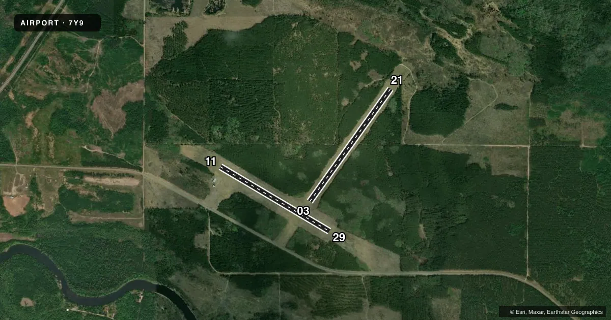
Runways & pattern
Full pagePattern entry · RWY 03
LEFT TRAFFIC| Runway | Heading (°M) | Length | Surface | Traffic |
|---|---|---|---|---|
| 03/21Favored | 32° / 212° | 2,850 ft | TURF | Standard L |
| 11/29 | 117° / 297° | 2,602 ft | TURF | Standard L |
Runway end performance
| End | TORA | TODA | ASDA | LDA | VGSI | Approach lights | Obstruction |
|---|---|---|---|---|---|---|---|
| 03 | — | — | — | — | — | — | 54', trees, 581' from thr, 72' R of cntrln, slope 10 |
| 21 | — | — | — | — | — | — | 47', trees, 581' from thr, 93' R of cntrln, slope 12 |
| 11 | — | — | — | — | — | — | 48', trees, 481' from thr, 172' R of cntrln, slope 10 |
| 29 | — | — | — | — | — | — | 93', trees, 1751' from thr, 225' R of cntrln, slope 18 |
Declared distances in feet. TORA = takeoff run available, TODA = takeoff distance, ASDA = accelerate-stop, LDA = landing distance.
Airport sketch
Runways drawn to scale from FAA survey coordinates, rendered over satellite imagery. Not for navigation.
Approaches & charts
Services on the field
Fuel grades, oxygen, maintenance, ramp storage and lighting — as declared to the FAA by the airport operator.
Fuel & services
- Fuel
- Not available
- Oxygen (bottled)
- Not available
- Oxygen (bulk)
- Not available
- Airframe repair
- Not available
- Power plant repair
- Not available
Ramp & ground
- Transient storage
- Tie-down
- Landing fee
- No fee published
- Customs
- Not available
- Lighting schedule
- SS-SR
- Wind indicator
- Lighted
- Segmented circle
- No
Fuel & FBOs
Cheapest 100LL and Jet A on the field and nearby. Always confirm with the FBO before taxi.
Airport notes
Surface conditions, obstructions, local procedures, lighting outages and other notes published with each FAA cycle.
General notes
- ARPT SFCS NOT PLOWED IN WINTER, FOR CONDS CALL AMGR OR CK NOTAMS.
- ULTRALIGHT TFC ON & INVOF ARPT.
- FOR CD CTC MINNEAPOLIS ARTCC AT 651-463-5588.
Runway surface & condition
- 11/29NSTD LIRL DUE TO SPACING.
Approach & departure obstructions
- 03YELLOW CONES.
- 11YELLOW CONES.
- 21YELLOW CONES.
- 29YELLOW CONES.
VFR map & nearby airports
VFR sectional. Tap any ICAO chip to open that airport.
Key facts · 7Y9
Answer card- ICAO
- 7Y9
- Name
- BIG FALLS MUNI
- Location
- BIG FALLS, MINNESOTA
- Elevation
- 1,233 ft MSL
- Traffic pattern altitude
- 2,233 ft MSL (1,000 AGL)
- Control tower
- Non-towered (use CTAF)
- Total runways
- 2
- Longest runway
- 03/21 · 2,850 ft
- Published ILS approaches
- 0
- Published frequencies
- 1
- Magnetic variation
- 3°
- Current flight rules
- VFR
- Current wind
- 030° at 8 kt
- Favored runway now
- RWY 03
BIG FALLS MUNI is in Big Falls, Minnesota. Field elevation is 1,233 ft MSL. The airport has two turf runways. The longest is runway 03/21 at 2,850 ft. There is no control tower. CTAF is 122.9. No ILS approaches are published here.
Pattern altitude is not published. Use the standard 1,000 ft AGL pattern for light piston operations unless the current Chart Supplement or local traffic calls for something different. Runway 11/29 has nonstandard low intensity runway lights because of spacing. Yellow cones mark the ends of runways 03, 11, 21 and 29. Ultralight traffic is on and in the vicinity of the airport. Keep a sharp scan in the pattern and on final.
There are no on-field FBOs listed. Plan to verify fuel and services with the airport operator or by calling the field before arrival. For clearance delivery, contact Minneapolis ARTCC at 651-463-5588. The airport surfaces are not plowed in winter. Check NOTAMs and call the airport manager for current surface conditions before you go. This is a turf field at modest elevation in northern Minnesota. Soft ground, snow and seasonal surface conditions can affect braking and rollout.