METAR & TAF KORB
Current METAR
Observed 19:15Z
KORB 271915Z AUTO VRB05KT 9SM SCT021 25/21 A2980 RMK AO2 T02520212
- Wind
- VAR @ 5 kt
- Visibility
- 9 SM
- Temp / Dew
- 25°C / 21°C
- Altimeter
- 29.80 inHg
- Clouds
- SCT
- Density alt
- 2,976 ft
- Ceiling
- Unlimited
- Rules
- VFR
Airport info & contacts
Manager on record, flight service, ARTCC, attendance schedule and pattern altitude — published by the FAA and refreshed every 28 days.
Location
- From city
- 3 NM SW
- VFR sectional
- GREEN BAY
- ARTCC
- ZMP · MINNEAPOLIS
- NOTAM facility
- ORB (NOTAM-D)
Airport manager
- Name
- ETHAN OLSON
- Phone
- 218-929-1458
- Address
- 4429 HIGHWAY 53, BOX 237, ORR MN 55771
Flight service · Hours
- FSS PNM
- PRINCETON1-800-WX-BRIEF
- Attendance
- Unattended
Frequencies
Tap any row to copy the frequency to your clipboard.
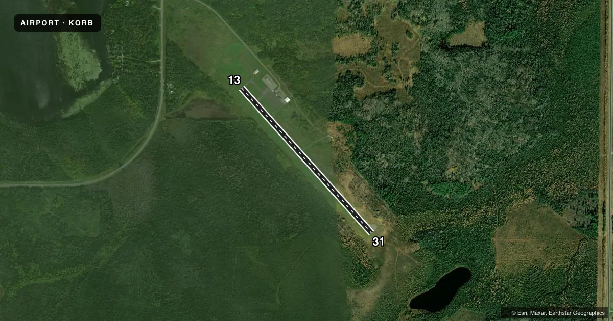
Runways & pattern
Full pagePattern entry · RWY 31
LEFT TRAFFICRunway end performance
| End | TORA | TODA | ASDA | LDA | VGSI | Approach lights | Obstruction |
|---|---|---|---|---|---|---|---|
| 13 | — | — | — | — | PAPI 4-box left(3°) | — | — |
| 31 | — | — | — | — | PAPI 4-box left(3°) | — | — |
Declared distances in feet. TORA = takeoff run available, TODA = takeoff distance, ASDA = accelerate-stop, LDA = landing distance.
Airport sketch
Runways drawn to scale from FAA survey coordinates, rendered over satellite imagery. Not for navigation.
Approaches & charts
Services on the field
Fuel grades, oxygen, maintenance, ramp storage and lighting — as declared to the FAA by the airport operator.
Fuel & services
- Fuel
- 100LLA
Ramp & ground
- Transient storage
- Tie-down
- Hangar
- Landing fee
- No fee published
- Customs
- Not available
- Lighting schedule
- SEE RMK
- Beacon schedule
- SS-SR
- Beacon
- White / Green (civil land)(WG)
- Wind indicator
- Lighted
- Segmented circle
- No
Fuel & FBOs
Cheapest 100LL and Jet A on the field and nearby. Always confirm with the FBO before taxi.
Airport notes
Surface conditions, obstructions, local procedures, lighting outages and other notes published with each FAA cycle.
General notes
- GCO AVBL ON FREQ 121.725 THRU MINNEAPOLIS ARTCC & FLT SVCS.
- BIRDS & WILDLIFE ON & INVOF ARPT.
- FOR CD IF UNA VIA GCO CTC MINNEAPOLIS ARTCC AT 651-463-5588.
Lighting notes
- MIRL RY 13/31 PRESET TO LOW SS-SR, INCR INTS AND ACTVT REIL RY 13/31; PAPI RY 13/31 - CTAF.
Fuel notes
- 100LL100LL AND JET A AVBL 24 HRS WITH CREDIT CARD.
VFR map & nearby airports
VFR sectional. Tap any ICAO chip to open that airport.
Key facts · KORB
Answer card- ICAO
- KORB
- Name
- ORR RGNL
- Location
- ORR, MINNESOTA
- Elevation
- 1,312.6 ft MSL
- Traffic pattern altitude
- 2,312.6 ft MSL (1,000 AGL)
- Control tower
- Non-towered (use CTAF)
- Total runways
- 1
- Longest runway
- 13/31 · 4,000 ft
- Published ILS approaches
- 0
- Published frequencies
- 2
- Magnetic variation
- 2°
- Current flight rules
- VFR
- Current wind
- 000° at 5 kt
- Favored runway now
- RWY 31
ORR RGNL sits in Orr, Minnesota. The field elevation is 1,312.6 ft MSL. It has one runway, 13/31, which is 4,000 ft long and paved. There is no control tower. CTAF and UNICOM are both 122.8. No ILS approaches are published here. Plan with the current chart and your own approach setup in mind.
The published pattern altitude is not listed. Use standard 1,000 ft AGL for light piston traffic unless the current Chart Supplement says otherwise. The on-field FBO is Orr Regional Airport. It carries 100LL and Jet A. Fuel is available 24 hours with a credit card. That is useful if you are arriving late or planning a quick turn.
A few operational notes matter here. Birds and wildlife are reported on and near the airport. Runway 13/31 has medium intensity lights that come up low from sunset to sunrise. Higher intensity is available. The runway end identifier lights are also active. The precision approach path indicator on 13/31 is controlled by CTAF. If you need clearance delivery and cannot get it through the ground communications outlet, contact Minneapolis ARTCC. For a first visit, expect a non-towered field with local traffic, wildlife and a single 4,000 ft runway at a fairly high field elevation.