METAR & TAF 12D
12D does not publish a METAR.
Showing the nearest reporting station: KCQM (COOK MUNI) · 16.3 NM away. Conditions at 12D may differ.
METAR · KCQM
Observed 00:35Z
KCQM 280035Z AUTO 06003KT 10SM CLR 25/20 A2982 RMK AO2
- Wind
- 060° @ 3 kt
- Visibility
- 10 SM
- Temp / Dew
- 25°C / 20°C
- Altimeter
- 29.82 inHg
- Clouds
- CLR
- Density alt
- 3,023 ft
- Ceiling
- Unlimited
- Rules
- VFR
Airport info & contacts
Manager on record, flight service, ARTCC, attendance schedule and pattern altitude — published by the FAA and refreshed every 28 days.
Location
- From city
- 1 NM NW
- VFR sectional
- GREEN BAY
- ARTCC
- ZMP · MINNEAPOLIS
- NOTAM facility
- PNM (NOTAM-D)
Airport manager
- Name
- JOHN BURGESS
- Phone
- 218-780-5902
- Address
- PO BOX 576, 602 MAIN ST, TOWER MN 55790-0576
Flight service · Hours
- FSS PNM
- PRINCETON1-800-WX-BRIEF
- Attendance
- Unattended
Frequencies
Tap any row to copy the frequency to your clipboard.
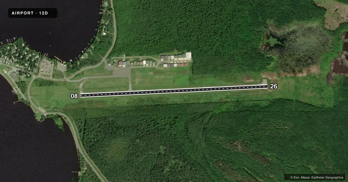
Runways & pattern
Full pagePattern entry · RWY 08
LEFT TRAFFICRunway end performance
| End | TORA | TODA | ASDA | LDA | VGSI | Approach lights | Obstruction |
|---|---|---|---|---|---|---|---|
| 08 | — | — | — | — | PAPI 2-box left(3°) | — | 32', brush, 478' from thr, 230' R of cntrln, slope 8 |
| 26 | — | — | — | — | PAPI 2-box left(3.5°) | — | 39', brush, 312' from thr, 233' R of cntrln, slope 2 |
Declared distances in feet. TORA = takeoff run available, TODA = takeoff distance, ASDA = accelerate-stop, LDA = landing distance.
Airport sketch
Runways drawn to scale from FAA survey coordinates, rendered over satellite imagery. Not for navigation.
Approaches & charts
Services on the field
Fuel grades, oxygen, maintenance, ramp storage and lighting — as declared to the FAA by the airport operator.
Fuel & services
- Fuel
- 100LL
- Other services
- BCHGR,INSTR,RNTL,SALES
Ramp & ground
- Transient storage
- Tie-down
- Landing fee
- No fee published
- Lighting schedule
- SEE RMK
- Wind indicator
- Lighted
- Segmented circle
- No
Fuel & FBOs
Cheapest 100LL and Jet A on the field and nearby. Always confirm with the FBO before taxi.
Airport notes
Surface conditions, obstructions, local procedures, lighting outages and other notes published with each FAA cycle.
General notes
- 270 FT HILL, 2500 FT SOUTHEAST OF ARPT.
- ULTRALIGHT TFC ON & INVOF ARPT.
- FOR CD CTC MINNEAPOLIS ARTCC AT 651-463-5588.
- COLD TEMPERATURE AIRPORT. ALTITUDE CORRECTION REQUIRED AT OR BELOW -34C.
Lighting notes
- ACTVT OR INCR INTST PAPI RWY 08 & 26; MIRL RWY 08/26 - CTAF. MIRL RWY 08/26 PRESET MED INTST.
Fuel notes
- 100LLFUEL AVBL H24 SELF SVC VIA CREDIT CARD.
Approach & departure obstructions
- 26UNUSBL BYD 4 DEGS LEFT OF CNTRLN.
VFR map & nearby airports
VFR sectional. Tap any ICAO chip to open that airport.
Key facts · 12D
Answer card- ICAO
- 12D
- Name
- TOWER MUNI
- Location
- TOWER, MINNESOTA
- Elevation
- 1,369.9 ft MSL
- Traffic pattern altitude
- 2,369.9 ft MSL (1,000 AGL)
- Control tower
- Non-towered (use CTAF)
- Total runways
- 1
- Longest runway
- 08/26 · 3,400 ft
- Published ILS approaches
- 0
- Published frequencies
- 1
- Magnetic variation
- 1°
- Current flight rules
- VFR
- Current wind
- 060° at 3 kt
- Favored runway now
- RWY 08
Tower Muni Airport is in Tower, Minnesota. The field elevation is 1,369.9 ft MSL. It has one runway, 08/26, which is 3,400 ft long and asphalt. There is no control tower. CTAF is 122.9. No ILS approaches are published here.
The pattern altitude is not published. Use the standard 1,000 ft AGL pattern unless the current Chart Supplement says otherwise. The on-field FBO is Tower Municipal Airport. It carries 100LL. Fuel is available 24 hours a day self-serve by credit card. The airport remarks also note that PAPI and medium intensity runway lights on 08 and 26 are activated on CTAF. The lights are preset to medium intensity.
This is a cold temperature airport. Altitude correction is required at or below minus 34 degrees Celsius. There is also a 270-foot hill about 2,500 feet southeast of the airport. Runway 26 is unusable beyond 4 degrees left of centerline. Ultralight traffic is on and in the vicinity of the airport. If you need a clearance, contact Minneapolis ARTCC at 651-463-5588. For a first-time arrival, brief the hill. Brief the runway 26 centerline note. Brief the CTAF lighting procedure before you go.