METAR & TAF KELO
Current METAR
Observed 23:15Z
KELO 232315Z AUTO 13006KT 9SM OVC095 20/07 A3010 RMK AO2 T02020066
- Wind
- 130° @ 6 kt
- Visibility
- 9 SM
- Temp / Dew
- 20°C / 7°C
- Altimeter
- 30.10 inHg
- Clouds
- OVC
- Density alt
- 2,182 ft
- Ceiling
- 9,500 ft AGL
- Rules
- VFR
Airport info & contacts
Manager on record, flight service, ARTCC, attendance schedule and pattern altitude — published by the FAA and refreshed every 28 days.
Location
- From city
- 4 NM S
- VFR sectional
- GREEN BAY
- ARTCC
- ZMP · MINNEAPOLIS
- NOTAM facility
- ELO (NOTAM-D)
Airport manager
- Name
- JIM PREBLICH
- Phone
- 218-365-5600
- Address
- 1583 HIGHWAY 1, ELY MN 55731-8209
Flight service · Hours
- FSS PNM
- PRINCETON1-800-WX-BRIEF
- Attendance
- 0800-1700
Frequencies
Tap any row to copy the frequency to your clipboard.
Runways & pattern
Full pagePattern entry · RWY 12
LEFT TRAFFICRunway end performance
| End | TORA | TODA | ASDA | LDA | VGSI | Approach lights | Obstruction |
|---|---|---|---|---|---|---|---|
| 12 | — | — | — | — | PAPI 4-box left(3°) | — | — |
| 30 | — | — | — | — | PAPI 4-box left(3°) | — | 90', tree, 2760' from thr, 616' R of cntrln, slope 28 |
Declared distances in feet. TORA = takeoff run available, TODA = takeoff distance, ASDA = accelerate-stop, LDA = landing distance.
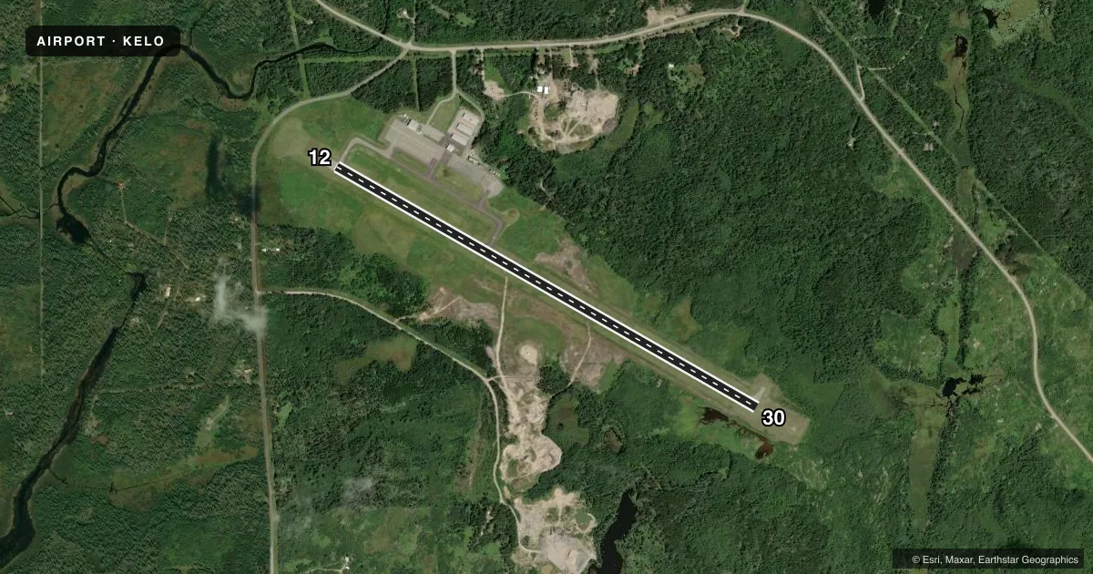
Airport sketch
Runways drawn to scale from FAA survey coordinates, rendered over satellite imagery. Not for navigation.
Approaches & charts
Services on the field
Fuel grades, oxygen, maintenance, ramp storage and lighting — as declared to the FAA by the airport operator.
Fuel & services
- Fuel
- 100LLA
- Oxygen (bottled)
- Not available
- Oxygen (bulk)
- Not available
- Airframe repair
- Not available
- Power plant repair
- Not available
Ramp & ground
- Transient storage
- Tie-down
- Hangar
- Landing fee
- No fee published
- Customs
- Not available
- Lighting schedule
- SEE RMK
- Beacon schedule
- SS-SR
- Beacon
- White / Green (civil land)(WG)
- Wind indicator
- Lighted
- Segmented circle
- Yes
Fuel & FBOs
Cheapest 100LL and Jet A on the field and nearby. Always confirm with the FBO before taxi.
Airport notes
Surface conditions, obstructions, local procedures, lighting outages and other notes published with each FAA cycle.
General notes
- FOR CD CTC MINNEAPOLIS ARTCC AT 651-463-5588.
Lighting notes
- ACTVT OR INCR INTST REIL RWY 12 & 30; PAPI RWY 12 & 30; MIRL RWY 12/30 - CTAF. MIRL RWY 12/30 PRESET LOW INTST.
Other notes
- 1FOR ATTENDANT AFT HRS CALL 218-343-8774.
VFR map & nearby airports
VFR sectional. Tap any ICAO chip to open that airport.
Key facts · KELO
Answer card- ICAO
- KELO
- Name
- ELY MUNI
- Location
- ELY, MINNESOTA
- Elevation
- 1,456 ft MSL
- Traffic pattern altitude
- 2,456 ft MSL (1,000 AGL)
- Control tower
- Non-towered (use CTAF)
- Total runways
- 1
- Longest runway
- 12/30 · 5,596 ft
- Published ILS approaches
- 0
- Published frequencies
- 2
- Magnetic variation
- 0°
- Current flight rules
- VFR
- Current wind
- 130° at 6 kt
- Favored runway now
- RWY 12
Ely Muni (KELO) sits in Ely, Minnesota. The field elevation is 1,456 ft MSL. It has one runway, 12/30, which is 5,596 ft long with an asphalt surface. The airport is not towered. CTAF and UNICOM are both 122.8. No ILS approaches are published here.
The pattern altitude is not published. Use 1,000 ft AGL for light piston operations unless the current Chart Supplement says otherwise. With 0° magnetic variation, runway headings are the same as the published magnetic numbers. The on-field FBO is Ely Municipal Airport. It carries 100LL and Jet A. Call ahead at (218) 365-5600 if you need current service details. The published remarks also note that runway end identifier lights, PAPI on both ends and the medium intensity runway lights are controlled from CTAF. The runway lights are preset to low intensity. For after-hours attendant help, the published number is 218-343-8774. For clearance delivery, contact Minneapolis ARTCC at 651-463-5588. Pilots should plan for a non-towered arrival. Verify any current lighting or operational notes before flying in.