METAR & TAF M56
M56 does not publish a METAR.
Showing the nearest reporting station: KCKC (GRAND MARAIS/COOK COUNTY) · 20.9 NM away. Conditions at M56 may differ.
METAR · KCKC
Observed 01:55Z
KCKC 280155Z AUTO 00000KT 5SM BR CLR 16/16 A2987 RMK AO2
- Wind
- 000° @ 0 kt
- Visibility
- 5 SM
- Temp / Dew
- 16°C / 16°C
- Altimeter
- 29.87 inHg
- Clouds
- CLR
- Density alt
- 2,098 ft
- Ceiling
- Unlimited
- Rules
- MVFR
Airport info & contacts
Manager on record, flight service, ARTCC, attendance schedule and pattern altitude — published by the FAA and refreshed every 28 days.
Location
- From city
- 26 NM NW
- VFR sectional
- GREEN BAY
- ARTCC
- ZMP · MINNEAPOLIS
- NOTAM facility
- PNM (NOTAM-D)
Airport manager
- Name
- JOHN FREDRIKSON
- Phone
- 218-388-0501
- Address
- 143 S GUNFLINT LAKE RD, GRAND MARAIS MN 55604
Flight service · Hours
- FSS PNM
- PRINCETON1-800-WX-BRIEF
- Attendance
- Unattended
Frequencies
Tap any row to copy the frequency to your clipboard.
Runways & pattern
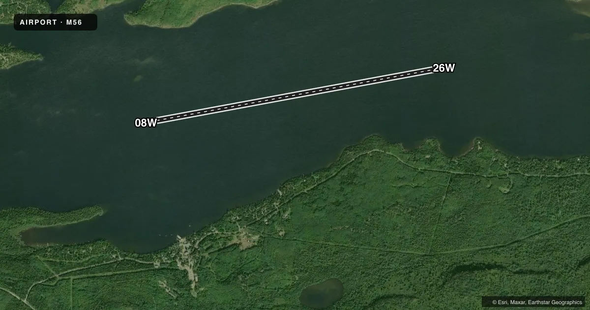
Full pagePattern entry · RWY 08W
LEFT TRAFFICAirport sketch
Runways drawn to scale from FAA survey coordinates, rendered over satellite imagery. Not for navigation.
Approaches & charts
Services on the field
Fuel grades, oxygen, maintenance, ramp storage and lighting — as declared to the FAA by the airport operator.
Fuel & services
- Fuel
- Not available
- Oxygen (bottled)
- Not available
- Oxygen (bulk)
- Not available
- Airframe repair
- Not available
- Power plant repair
- Not available
Ramp & ground
- Transient storage
- Tie-down
- Wind indicator
- Yes
- Segmented circle
- No
Fuel & FBOs
Cheapest 100LL and Jet A on the field and nearby. Always confirm with the FBO before taxi.
Airport notes
Surface conditions, obstructions, local procedures, lighting outages and other notes published with each FAA cycle.
VFR map & nearby airports
VFR sectional. Tap any ICAO chip to open that airport.
Key facts · M56
Answer card- ICAO
- M56
- Name
- GUNFLINT LODGE
- Location
- GRAND MARAIS, MINNESOTA
- Elevation
- 1,545 ft MSL
- Traffic pattern altitude
- 2,545 ft MSL (1,000 AGL)
- Control tower
- Non-towered (use CTAF)
- Total runways
- 1
- Longest runway
- 08W/26W · 6,000 ft
- Published ILS approaches
- 0
- Published frequencies
- 1
- Magnetic variation
- –
- Current flight rules
- MVFR
- Current wind
- 000° at 0 kt
- Favored runway now
- –
Gunflint Lodge sits near Grand Marais, Minnesota. The field elevation is 1,545 ft MSL. It has one runway. The longest runway is 08W/26W at 6,000 ft on water. There is no control tower. CTAF is 122.9.
No ILS approaches are published here. Pattern altitude is not published in the facts, so use standard light piston pattern planning at 1,000 ft AGL unless the current Chart Supplement says otherwise. With a water runway, the big picture is simple. Plan for a seaplane environment. Verify your landing and departure profile before you go. The airport sits in northern Minnesota near the Canadian border region, so weather and water conditions deserve close attention. There are no on-field FBOs listed in the facts. Contact the airport operator directly before arrival, or call the field on CTAF for current service availability.
For a first visit, treat this as a non-towered water strip with no published ILS backup. Keep your radio calls tight on 122.9. Check the current Chart Supplement for any changes to runway use, local procedures, or other operational notes before flying in.