METAR & TAF KCKC
Current METAR
Observed 22:15Z
KCKC 262215Z AUTO 21005KT 10SM CLR 26/22 A2976 RMK AO2
- Wind
- 210° @ 5 kt
- Visibility
- 10 SM
- Temp / Dew
- 26°C / 22°C
- Altimeter
- 29.76 inHg
- Clouds
- CLR
- Density alt
- 3,754 ft
- Ceiling
- Unlimited
- Rules
- VFR
Airport info & contacts
Manager on record, flight service, ARTCC, attendance schedule and pattern altitude — published by the FAA and refreshed every 28 days.
Location
- From city
- 7 NM NW
- VFR sectional
- GREEN BAY
- ARTCC
- ZMP · MINNEAPOLIS
- NOTAM facility
- CKC (NOTAM-D)
Airport manager
- Name
- RODNEY ROY
- Phone
- 218-387-3024
- Address
- 123 AIRPORT RD, GRAND MARAIS MN 55604-2304
Flight service · Hours
- FSS PNM
- PRINCETON1-800-WX-BRIEF
- Attendance
- MON-SAT · 0800-1700
- SUN · 0900-1700
Frequencies
Tap any row to copy the frequency to your clipboard.
Runways & pattern
Full pagePattern entry · RWY 28
LEFT TRAFFICRunway end performance
| End | TORA | TODA | ASDA | LDA | VGSI | Approach lights | Obstruction |
|---|---|---|---|---|---|---|---|
| 10 | — | — | — | — | PAPI 4-box left(3°) | — | 6', tree, 373' from thr, 177' R of cntrln, slope 28 |
| 28 | — | — | — | — | PAPI 4-box left(3°) | — | — |
Declared distances in feet. TORA = takeoff run available, TODA = takeoff distance, ASDA = accelerate-stop, LDA = landing distance.
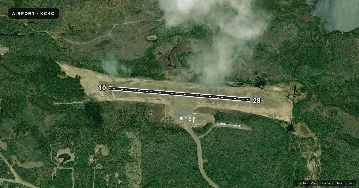
Airport sketch
Runways drawn to scale from FAA survey coordinates, rendered over satellite imagery. Not for navigation.
Approaches & charts
Services on the field
Fuel grades, oxygen, maintenance, ramp storage and lighting — as declared to the FAA by the airport operator.
Fuel & services
- Fuel
- 100LLA
- Airframe repair
- Major
- Power plant repair
- Major
- Other services
- INSTR,RNTL,SALES,SURV
Ramp & ground
- Transient storage
- Tie-down
- Hangar
- Landing fee
- No fee published
- Customs
- Not available
- Lighting schedule
- SEE RMK
- Beacon schedule
- SS-SR
- Beacon
- White / Green (civil land)(WG)
- Wind indicator
- Lighted
- Segmented circle
- Yes
Fuel & FBOs
Cheapest 100LL and Jet A on the field and nearby. Always confirm with the FBO before taxi.
Airport notes
Surface conditions, obstructions, local procedures, lighting outages and other notes published with each FAA cycle.
General notes
- CUST AVBL MAY 15-OCT 15.
- FOR CD IF UNA TO CTC ON FSS FREQ, CTC MINNEAPOLIS ARTCC AT 651-463-5588.
Lighting notes
- ACTVT OR INCR INTST REIL RWY 10 & 28; PAPI RWY 10 & 28; MIRL RWY 10/28 - CTAF. MIRL RWY 10/28 PRESET LOW INTST.
Fuel notes
- 100LLFOR SVC AFT HRS CALL 218-387-2012.
Approach & departure obstructions
- 28CALM WIND RWY.
VFR map & nearby airports
VFR sectional. Tap any ICAO chip to open that airport.
Key facts · KCKC
Answer card- ICAO
- KCKC
- Name
- GRAND MARAIS/COOK COUNTY
- Location
- GRAND MARAIS, MINNESOTA
- Elevation
- 1,803 ft MSL
- Traffic pattern altitude
- 2,803 ft MSL (1,000 AGL)
- Control tower
- Non-towered (use CTAF)
- Total runways
- 1
- Longest runway
- 10/28 · 5,002 ft
- Published ILS approaches
- 0
- Published frequencies
- 2
- Magnetic variation
- 1°
- Current flight rules
- VFR
- Current wind
- 210° at 5 kt
- Favored runway now
- RWY 28
Grand Marais/Cook County Airport sits in Grand Marais, Minnesota. Field elevation is 1,803 ft MSL. The airport has one runway. Runway 10/28 is 5,002 ft long with asphalt pavement. No tower is published, so plan to self-announce on CTAF 122.8. UNICOM is also 122.8. No ILS approaches are published here.
Pattern altitude is not published in the facts block. Use the standard 1,000 ft AGL for light piston traffic unless the current Chart Supplement says otherwise. Runway 28 is the calm wind runway. That matters here when the wind is light or variable. The field also has runway end identifier lights, PAPI on runways 10 and 28, plus medium intensity runway lights on 10/28. Those lights are preset to low intensity.
Roy Aero Service is on the field. It carries 100LL and Jet A. After-hours fuel service is available by phone. The airport remarks also note customs service from May 15 to October 15. For clearance delivery, if you cannot reach Flight Service, contact Minneapolis ARTCC. This is a northern Minnesota field with a higher elevation than many lakefront airports. Check density altitude, especially on warm days. Verify the current Chart Supplement for any changes before you go.