METAR & TAF 23W
23W does not publish a METAR.
Showing the nearest reporting station: KASX (JOHN F KENNEDY MEML) · 20.2 NM away. Conditions at 23W may differ.
METAR · KASX
Observed 04:02Z
KASX 270402Z AUTO VRB06KT 6SM -TSRA FEW048 SCT110 23/19 A2977 RMK AO2 LTG DSNT N AND SE AND NW TSB0356 PRESRR P0004 T02280194
- Wind
- VAR @ 6 kt
- Visibility
- 6 SM
- Temp / Dew
- 23°C / 19°C
- Altimeter
- 29.77 inHg
- Clouds
- SCT
- Density alt
- 2,085 ft
- Ceiling
- Unlimited
- Rules
- VFR
Airport info & contacts
Manager on record, flight service, ARTCC, attendance schedule and pattern altitude — published by the FAA and refreshed every 28 days.
Location
- From city
- 1 NM W
- VFR sectional
- GREEN BAY
- ARTCC
- ZMP · MINNEAPOLIS
- NOTAM facility
- GRB
Airport manager
- Name
- TIM KASENO
- Phone
- 612-877-1095
- Address
- BOX 296, CORNUCOPIA WI 54827
Flight service · Hours
- FSS GRB
- GREEN BAY1-800-WX-BRIEF
- Attendance
- Unattended
Frequencies
Tap any row to copy the frequency to your clipboard.
Runways & pattern
Full pagePattern entry · RWY 05
LEFT TRAFFICRunway end performance
| End | TORA | TODA | ASDA | LDA | VGSI | Approach lights | Obstruction |
|---|---|---|---|---|---|---|---|
| 05 | — | — | — | — | — | — | 50', trees, 30' from thr, 115' R of cntrln, slope 0 |
Declared distances in feet. TORA = takeoff run available, TODA = takeoff distance, ASDA = accelerate-stop, LDA = landing distance.
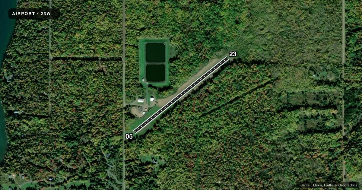
Airport sketch
Runways drawn to scale from FAA survey coordinates, rendered over satellite imagery. Not for navigation.
Approaches & charts
Services on the field
Fuel grades, oxygen, maintenance, ramp storage and lighting — as declared to the FAA by the airport operator.
Fuel & services
- Fuel
- Not available
- Airframe repair
- Not available
- Power plant repair
- Not available
Ramp & ground
- Transient storage
- Tie-down
- Landing fee
- No fee published
- Wind indicator
- Yes
- Segmented circle
- No
Fuel & FBOs
Cheapest 100LL and Jet A on the field and nearby. Always confirm with the FBO before taxi.
Airport notes
Surface conditions, obstructions, local procedures, lighting outages and other notes published with each FAA cycle.
General notes
- RWY 05/23 SW END TRRN DROPS OFF APRXLY 8-10 FT IN LAST 200 FT.
- FOR CD CTC MINNEAPOLIS ARTCC AT 651-463-5588.
- FOR FLD CONDS, CALL 612-877-1095.
Approach & departure obstructions
- 05MKD WITH YELLOW CONES.
- 05MKD WITH ORANGE PYLONS.
- 23MKD WITH YELLOW CONES.
- 05APCH RATIO 20:1 TO DSPLCD THR.
VFR map & nearby airports
VFR sectional. Tap any ICAO chip to open that airport.
Key facts · 23W
Answer card- ICAO
- 23W
- Name
- CORNUCOPIA FLD
- Location
- CORNUCOPIA, WISCONSIN
- Elevation
- 757 ft MSL
- Traffic pattern altitude
- 1,757 ft MSL (1,000 AGL)
- Control tower
- Non-towered (use CTAF)
- Total runways
- 1
- Longest runway
- 05/23 · 2,120 ft
- Published ILS approaches
- 0
- Published frequencies
- 1
- Magnetic variation
- 1°
- Current flight rules
- VFR
- Current wind
- 000° at 6 kt
- Favored runway now
- RWY 05
Cornucopia Fld sits in Cornucopia, Wisconsin. Field elevation is 757 ft MSL. It has one runway. Runway 05/23 is 2,120 ft of turf, which makes this a short-field stop for light aircraft. There is no control tower. CTAF is 122.9. No ILS approaches are published.
Pattern altitude is not published. Use the standard 1,000 ft AGL pattern unless local guidance says otherwise. The runway markings matter here. Runway 05 has orange pylons. The displaced threshold on 05 is marked with yellow cones. Runway 23 is marked with yellow cones. The southwest end of 05/23 drops off about 8 to 10 feet in the last 200 feet, so pay close attention on rollout and takeoff planning.
There are no on-field FBOs listed. Check with the airport operator or call the field directly before arrival for current services. For clearance delivery, contact Minneapolis ARTCC at 651-463-5588. For field conditions, call 612-877-1095. With no tower and a turf surface, a good radio scan and a careful look at the runway condition are part of the brief here.