METAR & TAF SS1
SS1 does not publish a METAR.
Showing the nearest reporting station: KOLG (SOLON SPRINGS MUNI) · 3.5 NM away. Conditions at SS1 may differ.
METAR · KOLG
Observed 20:35Z
KOLG 272035Z AUTO 36008KT 330V030 10SM CLR 25/19 A2977 RMK AO1
- Wind
- 360° @ 8 kt
- Visibility
- 10 SM
- Temp / Dew
- 25°C / 19°C
- Altimeter
- 29.77 inHg
- Clouds
- CLR
- Density alt
- 2,626 ft
- Ceiling
- Unlimited
- Rules
- VFR
Airport info & contacts
Manager on record, flight service, ARTCC, attendance schedule and pattern altitude — published by the FAA and refreshed every 28 days.
Location
- From city
- 1 NM E
- VFR sectional
- GREEN BAY
- ARTCC
- ZMP · MINNEAPOLIS
- NOTAM facility
- GRB (NOTAM-D)
Airport manager
- Name
- DAN KEPHART
- Phone
- 715-296-7728
- Address
- 6250 SOUTH RANGER RD, BRULE WI 54820
Flight service · Hours
- FSS GRB
- GREEN BAY1-800-WX-BRIEF
- Attendance
- Unattended
Frequencies
Tap any row to copy the frequency to your clipboard.
Runways & pattern
Full pagePattern entry · RWY 04W
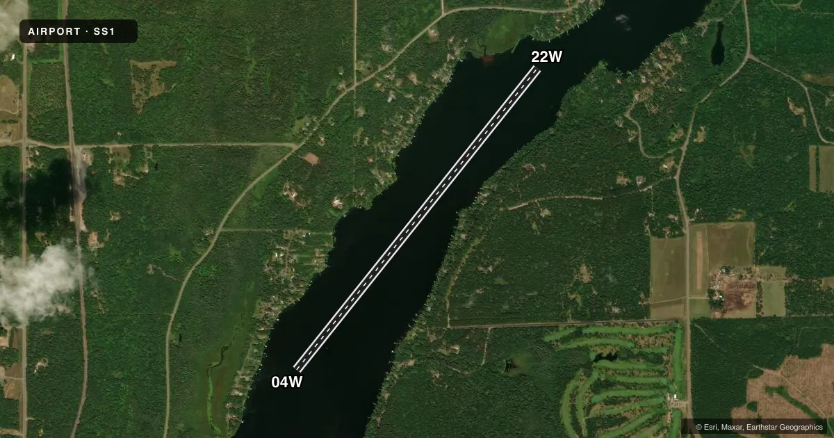
LEFT TRAFFICAirport sketch
Runways drawn to scale from FAA survey coordinates, rendered over satellite imagery. Not for navigation.
Approaches & charts
Services on the field
Fuel grades, oxygen, maintenance, ramp storage and lighting — as declared to the FAA by the airport operator.
Fuel & services
- Fuel
- Not available
- Oxygen (bottled)
- Not available
- Oxygen (bulk)
- Not available
- Airframe repair
- Not available
- Power plant repair
- Not available
Ramp & ground
- Transient storage
- Not published
- Segmented circle
- No
Fuel & FBOs
Cheapest 100LL and Jet A on the field and nearby. Always confirm with the FBO before taxi.
Airport notes
Surface conditions, obstructions, local procedures, lighting outages and other notes published with each FAA cycle.
General notes
- FOR CD CTC MINNEAPOLIS ARTCC AT 651-463-5588.
- DOCK IS FOR LOADING AND UNLOADING PURPOSES ONLY.
- NO BLXG DOCK OR BOAT RAMP.
- NO OVNGT PRKG.
- NO COML USE WO PMT.
Other notes
- PRVDD VFR OPS & CLEAR 20:1 APCHS.
VFR map & nearby airports
VFR sectional. Tap any ICAO chip to open that airport.
Key facts · SS1
Answer card- ICAO
- SS1
- Name
- NORTH COUNTRY
- Location
- SOLON SPRINGS, WISCONSIN
- Elevation
- 1,000 ft MSL
- Traffic pattern altitude
- 2,000 ft MSL (1,000 AGL)
- Control tower
- Non-towered (use CTAF)
- Total runways
- 1
- Longest runway
- 04W/22W · 6,000 ft
- Published ILS approaches
- 0
- Published frequencies
- 1
- Magnetic variation
- –
- Current flight rules
- VFR
- Current wind
- 360° at 8 kt
- Favored runway now
- RWY 04W
North Country is in Solon Springs, Wisconsin. Field elevation is 1,000 ft MSL. The airport has one runway. It is a 6,000 ft water runway, 04W/22W, with magnetic headings of 038.6° and 218.6°. There is no control tower. CTAF is 122.9.
No ILS approaches are published here. Pattern altitude is not published. Use the standard 1,000 ft AGL pattern for light piston operations unless the current FAA Chart Supplement says otherwise. The field is set up for VFR use. Published remarks also note that the dock is for loading and unloading only. Do not block the dock or boat ramp. No overnight parking is allowed. Commercial use requires a permit.
There are no on-field FBOs listed. Plan fuel and services with the airport operator or the FBO directly by phone before arrival. For IFR clearance delivery, contact Minneapolis ARTCC at 651-463-5588. Pilots should also pay attention to the water runway environment and the published 20 to 1 approach guidance. If you are new to the field, review the current FAA Chart Supplement before you go.