METAR & TAF KDLH
Current METAR
Observed 22:55Z
KDLH 272255Z 10009KT 10SM BKN007 19/17 A2983 RMK AO2 SLP099 T01890167 $
- Wind
- 100° @ 9 kt
- Visibility
- 10 SM
- Temp / Dew
- 19°C / 17°C
- Altimeter
- 29.83 inHg
- Clouds
- BKN
- Density alt
- 2,362 ft
- Ceiling
- 700 ft AGL
- Rules
- IFR
Airport info & contacts
Manager on record, flight service, ARTCC, attendance schedule and pattern altitude — published by the FAA and refreshed every 28 days.
Location
- From city
- 5 NM NW
- VFR sectional
- GREEN BAY
- ARTCC
- ZMP · MINNEAPOLIS
- NOTAM facility
- DLH (NOTAM-D)
Airport manager
- Name
- RYAN WELCH
- Phone
- 218-727-2968
- Address
- 4701 GRINDEN DR, DULUTH MN 55811-1578
Flight service · Hours
- FSS PNM
- PRINCETON1-800-WX-BRIEF
- Attendance
- ALL
Frequencies
Tap any row to copy the frequency to your clipboard.
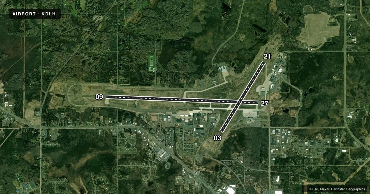
Runways & pattern
Full pagePattern entry · RWY 09
LEFT TRAFFIC| Runway | Heading (°M) | Length | Surface | Traffic |
|---|---|---|---|---|
| 09/27Favored | 91° / 271° | 10,591 ft | CONC | Standard L |
| 03/21 | 31° / 211° | 5,719 ft | ASPH | Standard L |
Runway end performance
| End | TORA | TODA | ASDA | LDA | VGSI | Approach lights | Obstruction |
|---|---|---|---|---|---|---|---|
| 09 | 10,591' | 10,591' | 10,062' | 10,062' | PAPI 4-box left(3°) | ALSF2 | 93', tree, 2797' from thr, 873' R of cntrln, slope 27 |
| 27 | 10,591' | 10,591' | 10,591' | 10,062' | PAPI 4-box left(3°) | MALSR | 26', tree, 1376' from thr, 133' R of cntrln, slope 45 |
| 03 | 5,719' | 5,719' | 5,719' | 5,719' | PAPI 4-box left(3°) | — | 51', tree, 2194' from thr, 217' R of cntrln, slope 39 |
| 21 | 5,719' | 5,719' | 5,719' | 5,719' | PAPI 4-box left(3°) | — | 30', tree, 1289' from thr, 324' R of cntrln, slope 36 |
Declared distances in feet. TORA = takeoff run available, TODA = takeoff distance, ASDA = accelerate-stop, LDA = landing distance.
Airport sketch
Runways drawn to scale from FAA survey coordinates, rendered over satellite imagery. Not for navigation.
Approaches & charts
ILS · 2
Services on the field
Fuel grades, oxygen, maintenance, ramp storage and lighting — as declared to the FAA by the airport operator.
Fuel & services
- Fuel
- 100LLAJ8
- Oxygen (bottled)
- HIGH/LOW
- Oxygen (bulk)
- HIGH/LOW
- Airframe repair
- Major
- Power plant repair
- Major
- Other services
- AFRT,CARGO,CHTR,INSTR,RNTL,SALES
Ramp & ground
- Transient storage
- Tie-down
- Hangar
- Landing fee
- Yes
- Customs
- Available
- Beacon schedule
- SS-SR
- Beacon
- White / Green (civil land)(WG)
- Wind indicator
- Yes
- Segmented circle
- No
Fuel & FBOs
Cheapest 100LL and Jet A on the field and nearby. Always confirm with the FBO before taxi.
Airport notes
Surface conditions, obstructions, local procedures, lighting outages and other notes published with each FAA cycle.
General notes
- BIRDS ON & INVOF ARPT.
- HIGH SPEED MILITARY JET TRAFFIC NOT ON ADS-B OPERATING IN AND ABOVE CLASS D AIRSPACE FROM 3000' TO 11,500' MSL CTC DLH APP FOR TRFC ADZYS FOR TRANSIT RCMDD.
- WHEN RWY 03/21 IN USE; TWY C NORTH OF RWY 09/27 MAY BE RESTRICTED BY ATC TO ACFT WITH WINGSPANS LESS THAN 49 FT.
- JASU: 9(AM32A-60) 2(A/M32A-86) 2(MC-11) 6(MC-2A) (MIL).
- SP DE-ICE LHOX LHNIT.
- OIL: O-148(MIL). JOAP.
- CAUTION: BIRD HAZ. (PHASE II CONDITIONS) EXISTS DUR 1 SEP THRU 31 OCT. CTC SOF/AFLD MGR/COMD POST FOR INFO.
- FLIGHT NOTIFICATION SERVICE (ADCUS) AVBL.
- FUEL: A+, J8 (MONACO AIR DULUTH, C218-727-2911.) (NC-100LL, A). A++(MIL) (ANG, C218-788-7340).
- PPR ALL ACFT. OPR 1200-2130Z++ MON-FRI, EXC HOL AND FLEX DAYS. LTD OPR HR AND TRAN SVC AVBL. CTC AFLD MGT DSN 825-7252, C218-788-7252, OPS DESK DSN 825-7399, C218-788-7399, COMD POST DSN 825-7370/7371, C218-788-7370/7371. FTR ACFT AND C12/C21 CARGO ACFT MAY ENTER ANG RAMP VIA TWY E OR H. ALL OTHER NON-FTR ACFT USE TWY F TO ENTER ANG RAMP. PER GIANT REPORT, TWY F CURRENTLY RSTD TO ONLY C17/C130 ACFT. ALL OTHER CARGO AMC ACFT MUST PARK AT MIDFIELD RAMP. ALL TRAN ACFT WILL CTC COMD POST 15 MIN PRIOR TO LDG. TRAN ACFT WILL CTC COMD POST BEFORE ENGINE STARTUP AND BEFORE TAXI. NO SVC AVAILABLE WHEN WIND CHILL EXCEEDS OR IS FCST TO EXCEED -30-F. FOR RCR INFO, AFLD STATUS AND CRASH RESCUE CAPABILITY CTC COMD POST OR TWR. NONSTD MRK FOR ALERT/MAINT VEH, ACFT GND EQPT PRK SPOTS.
- ACFT DEICE TYPE 1 & 4 FLUID AVBL - CTC FBO C218-727-2911.
- US CUST INTL AOE (NO FEES) AVBL H24 C218-720-5203 THEN PRESS 0. CUST CLEARING LCTD AT FBO.
- FOR MIL TSNT ACFT PRKG, RFLG, & SER OFF ANG CTC FBO C218-727-2977 H24.
Fuel notes
- J8AVBL AT MIL & CIVIL FUELING FACILITIES.
Runway surface & condition
- 03/21WEIGHT BEARING STRENGTH - 2S127.
- 09/27WEIGHT BEARING STRENGTH - 2S153.
- 03/21PCR VALUE: 400/F/B/X/T
- 09/27PCR VALUE: 570/R/B/W/T
Approach & departure obstructions
- 27CAUTION: WINDSHEAR/DOWNDRAFTS FINAL APCH.
Arresting gear
- 09_BAK-12TYPE H BAK-12B(B) 1470 FT.
- 27_BAK-12TYPE H BAK 12B(B) 2544 FT.
Other notes
- ARFF INDEX D AVBL H24 WITH 2 HR PPR - CTC ANG 218-788-7434.
- LDG FEE FOR ALL COML ACFT & ALL ACFT OVR 12500 LB MAX LDG WT EXC ACFT OPRD OR CHTRD BY THE US GOVT OR THE STATE OF MINNESOTA.
VFR map & nearby airports
VFR sectional. Tap any ICAO chip to open that airport.
Key facts · KDLH
Answer card- ICAO
- KDLH
- Name
- DULUTH INTL
- Location
- DULUTH, MINNESOTA
- Elevation
- 1,427.8 ft MSL
- Traffic pattern altitude
- 2,427.8 ft MSL (1,000 AGL)
- Control tower
- Towered · 24
- Total runways
- 2
- Longest runway
- 09/27 · 10,591 ft
- Published ILS approaches
- 2
- Published frequencies
- 12
- Magnetic variation
- 1°
- Current flight rules
- IFR
- Current wind
- 100° at 9 kt
- Favored runway now
- RWY 09
Duluth Intl is in Duluth, Minnesota. Field elevation is 1,427.8 ft MSL. The airport has 2 runways. The longest is 10,591 ft. Runway 09/27 is concrete. Runway 03/21 is asphalt. The tower is open 24 hours.
Two ILS approaches are published for runway ends 09 and 27. Pattern altitude is not published in the facts, so verify the current Chart Supplement before you fly. Vantage Aviation is on the field. It carries 100LL, Jet A and Jet A Prist. The published remarks also note fuel availability at Monaco Air Duluth. It lists 100LL, Avgas, Jet A plus and Jet A-8. If you need current service details, call the FBO directly.
This is a busy controlled field with military activity. The remarks say prior permission is required for all aircraft. Transient aircraft must contact command post before landing, before engine start and before taxi. Bird activity is also noted. The higher bird hazard period runs from September 1 through October 31. The field sits in the Duluth area, so expect lake and terrain effects to matter on a local weather day. Check the current Chart Supplement for any noise or operating restrictions before departure.