METAR & TAF Y77
Y77 does not publish a METAR.
Showing the nearest reporting station: KOLG (SOLON SPRINGS MUNI) · 21.7 NM away. Conditions at Y77 may differ.
METAR · KOLG
Observed 20:35Z
KOLG 272035Z AUTO 36008KT 330V030 10SM CLR 25/19 A2977 RMK AO1
- Wind
- 360° @ 8 kt
- Visibility
- 10 SM
- Temp / Dew
- 25°C / 19°C
- Altimeter
- 29.77 inHg
- Clouds
- CLR
- Density alt
- 2,792 ft
- Ceiling
- Unlimited
- Rules
- VFR
Airport info & contacts
Manager on record, flight service, ARTCC, attendance schedule and pattern altitude — published by the FAA and refreshed every 28 days.
Location
- From city
- 2 NM NW
- VFR sectional
- GREEN BAY
- ARTCC
- ZMP · MINNEAPOLIS
- NOTAM facility
- GRB (NOTAM-D)
Airport manager
- Name
- PAT MCDONOUGH
- Phone
- (715) 372-4848
- Address
- 66615 WILLS RD, BRULE WI 54820
Flight service · Hours
- FSS GRB
- GREEN BAY1-800-WX-BRIEF
- Attendance
- UNATTND
Frequencies
Tap any row to copy the frequency to your clipboard.
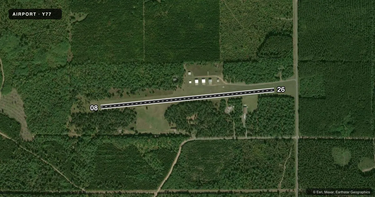
Runways & pattern
Full pagePattern entry · RWY 08
LEFT TRAFFICRunway end performance
| End | TORA | TODA | ASDA | LDA | VGSI | Approach lights | Obstruction |
|---|---|---|---|---|---|---|---|
| 08 | — | — | — | — | — | — | 37', trees, 0' from thr, 85' R of cntrln, slope 0 |
| 26 | — | — | — | — | VASI 2-box left | — | 10', road, 0' from thr, 110' R of cntrln, slope 0 |
Declared distances in feet. TORA = takeoff run available, TODA = takeoff distance, ASDA = accelerate-stop, LDA = landing distance.
Airport sketch
Runways drawn to scale from FAA survey coordinates, rendered over satellite imagery. Not for navigation.
Approaches & charts
Services on the field
Fuel grades, oxygen, maintenance, ramp storage and lighting — as declared to the FAA by the airport operator.
Fuel & services
- Fuel
- Not available
- Oxygen (bottled)
- Not available
- Oxygen (bulk)
- Not available
- Airframe repair
- Not available
- Power plant repair
- Not available
Ramp & ground
- Transient storage
- Tie-down
- Landing fee
- No fee published
- Lighting schedule
- SEE RMK
- Wind indicator
- Lighted
- Segmented circle
- No
Fuel & FBOs
Cheapest 100LL and Jet A on the field and nearby. Always confirm with the FBO before taxi.
Airport notes
Surface conditions, obstructions, local procedures, lighting outages and other notes published with each FAA cycle.
General notes
- CONFIRM WINTER CONDS AND SNOW REMOVAL WITH AMGR 715-372-4848.
- OCCASIONAL WILD GAME ON & INVOF ARPT.
- FOR CD CTC MINNEAPOLIS ARTCC AT 651-463-5588.
Lighting notes
- ACTVT LIRL RY 08/26 - CTAF.
Runway surface & condition
- 08/26NSTD LIRL - 1 LGT EA SIDE OF THLD.
Approach & departure obstructions
- 08MKD WITH RED & WHITE A-FRAMES.
- 26MKD WITH RED & WHITE A-FRAMES.
- 08CTLNG OBSTN EXCEEDS A 45 DEG SLP.
- 26CTLNG OBSTN EXCEEDS A 45 DEG SLP.
Other notes
- MAN-MADE OR NATURAL OBJECTS EXIST WITHIN THE AIRSPACE NEEDED TO INSURE SAFETY IN TAKEOFF AND LANDING OF AIRCRAFT.
VFR map & nearby airports
VFR sectional. Tap any ICAO chip to open that airport.
Key facts · Y77
Answer card- ICAO
- Y77
- Name
- BAYFIELD COUNTY
- Location
- IRON RIVER, WISCONSIN
- Elevation
- 1,134 ft MSL
- Traffic pattern altitude
- 2,134 ft MSL (1,000 AGL)
- Control tower
- Non-towered (use CTAF)
- Total runways
- 1
- Longest runway
- 08/26 · 3,007 ft
- Published ILS approaches
- 0
- Published frequencies
- 1
- Magnetic variation
- 1°
- Current flight rules
- VFR
- Current wind
- 360° at 8 kt
- Favored runway now
- RWY 08
Bayfield County Airport sits in Iron River, Wisconsin. Field elevation is 1,134 ft MSL. The airport has one runway, 08/26, which is 3,007 ft long and surfaced with turf. There is no control tower. CTAF is 122.9. No ILS approaches are published here.
The pattern altitude is not published. Use the standard 1,000 ft AGL pattern unless the current Chart Supplement or airport operator gives you a different instruction. The runway lighting is low intensity and is activated by CTAF on 08/26. Runway 08 is marked with red and white A-frames. Runway 26 is marked the same way. Published remarks also note controlling obstructions on both ends that exceed a 45 degree slope. That is a real factor for takeoff and landing planning.
No on-field FBOs are listed, so plan to confirm services before arrival. Winter conditions and snow removal should be checked with the airport manager before you go. Occasional wild game is also noted on and near the airport. For clearance delivery, contact Minneapolis ARTCC. This is a small non-towered field with turf surface and local terrain or obstruction issues near both runway ends. Treat it like a careful short-field planning stop, especially in winter or when the surface is soft.