METAR & TAF 5G4
5G4 does not publish a METAR.
Showing the nearest reporting station: KOLG (SOLON SPRINGS MUNI) · 13.4 NM away. Conditions at 5G4 may differ.
METAR · KOLG
Observed 13:35Z
KOLG 271335Z AUTO 35006KT 10SM SCT012 BKN020 BKN028 26/24 A2968 RMK AO1
- Wind
- 350° @ 6 kt
- Visibility
- 10 SM
- Temp / Dew
- 26°C / 24°C
- Altimeter
- 29.68 inHg
- Clouds
- BKN
- Density alt
- 3,120 ft
- Ceiling
- 2,000 ft AGL
- Rules
- MVFR
Airport info & contacts
Manager on record, flight service, ARTCC, attendance schedule and pattern altitude — published by the FAA and refreshed every 28 days.
Location
- From city
- 10 NM W
- VFR sectional
- GREEN BAY
- ARTCC
- ZMP · MINNEAPOLIS
- NOTAM facility
- GRB (NOTAM-D)
Airport manager
- Name
- BRETT FRIERMOOD
- Phone
- 715-558-4228
- Address
- 3685 COUNTY HIGHWAY N, BARNES WI 54873
Flight service · Hours
- FSS GRB
- GREEN BAY1-800-WX-BRIEF
- Attendance
- Unattended
Frequencies
Tap any row to copy the frequency to your clipboard.
Runways & pattern
Full pagePattern entry · RWY 36
LEFT TRAFFICRunway end performance
| End | TORA | TODA | ASDA | LDA | VGSI | Approach lights | Obstruction |
|---|---|---|---|---|---|---|---|
| 18 | — | — | — | — | — | — | 50', trees, 0' from thr, 100' R of cntrln, slope 0 |
| 36 | — | — | — | — | — | — | 18', pole, 40' from thr, 115' R of cntrln, slope 2 |
Declared distances in feet. TORA = takeoff run available, TODA = takeoff distance, ASDA = accelerate-stop, LDA = landing distance.
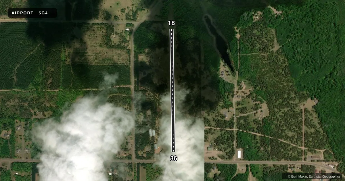
Airport sketch
Runways drawn to scale from FAA survey coordinates, rendered over satellite imagery. Not for navigation.
Approaches & charts
Services on the field
Fuel grades, oxygen, maintenance, ramp storage and lighting — as declared to the FAA by the airport operator.
Fuel & services
- Fuel
- Not available
- Oxygen (bottled)
- Not available
- Oxygen (bulk)
- Not available
- Airframe repair
- Not available
- Power plant repair
- Not available
Ramp & ground
- Transient storage
- Tie-down
- Landing fee
- No fee published
- Customs
- Not available
- Wind indicator
- Yes
- Segmented circle
- No
Fuel & FBOs
Cheapest 100LL and Jet A on the field and nearby. Always confirm with the FBO before taxi.
Airport notes
Surface conditions, obstructions, local procedures, lighting outages and other notes published with each FAA cycle.
General notes
- ARPT CLSD TO WHEELED ACFT WHEN RWYS COVD WITH SNOW OR ICE.
- FOR CD CTC MINNEAPOLIS ARTCC AT 651-463-5588.
Approach & departure obstructions
- 18MKD WITH SILVER/YELLOW A-FRAMES, ORANGE CONES, & TIRES.
- 36MKD WITH TIRES.
- 18CONTROLLING OBSTN EXCEEDS A 45 DEG SLP.
VFR map & nearby airports
VFR sectional. Tap any ICAO chip to open that airport.
Key facts · 5G4
Answer card- ICAO
- 5G4
- Name
- EAU CLAIRE LAKES
- Location
- DRUMMOND, WISCONSIN
- Elevation
- 1,212 ft MSL
- Traffic pattern altitude
- 2,212 ft MSL (1,000 AGL)
- Control tower
- Non-towered (use CTAF)
- Total runways
- 1
- Longest runway
- 18/36 · 2,308 ft
- Published ILS approaches
- 0
- Published frequencies
- 1
- Magnetic variation
- 1°
- Current flight rules
- MVFR
- Current wind
- 350° at 6 kt
- Favored runway now
- RWY 36
Eau Claire Lakes Airport (5G4) sits in Drummond, Wisconsin. Field elevation is 1,212 ft MSL. The airport has one runway, 18/36 and the longest runway is 2,308 ft of turf. There is no control tower. CTAF is 122.9. No ILS approaches are published here.
The published pattern altitude is not listed. Use standard 1,000 ft AGL unless the current Chart Supplement says otherwise. With a field elevation of 1,212 ft MSL, that puts the standard pattern near 2,212 ft MSL. Runway 18 is marked with silver and yellow A-frames, orange cones and tires. Runway 36 is marked with tires. The published remarks also note an obstruction near runway 18 that exceeds a 45 degree slope. That makes a careful look at the departure path smart before you go.
There are no on-field FBOs listed. Check with the airport operator or the FBO directly by phone before arrival if you need services. The airport is closed to wheeled aircraft when the runways are covered with snow or ice. For clearance delivery, contact Minneapolis ARTCC at 651-463-5588. This is a turf field with a short runway. Plan conservatively, especially if the surface is soft or contaminated.