METAR & TAF KDYT
Current METAR
Observed 21:55Z
KDYT 272155Z AUTO 02005KT 9SM 16/16 A2981 RMK AO2
- Wind
- 020° @ 5 kt
- Visibility
- 9 SM
- Temp / Dew
- 16°C / 16°C
- Altimeter
- 29.81 inHg
- Clouds
- Clear
- Density alt
- 1,011 ft
- Ceiling
- Unlimited
- Rules
- VFR
Airport info & contacts
Manager on record, flight service, ARTCC, attendance schedule and pattern altitude — published by the FAA and refreshed every 28 days.
Location
- From city
- 6 NM SE
- VFR sectional
- GREEN BAY
- ARTCC
- ZMP · MINNEAPOLIS
- NOTAM facility
- DYT (NOTAM-D)
Airport manager
- Name
- TRISTAN DURFEE
- Phone
- 218-733-0078
- Address
- DULUTH AIRPORT AUTHORITY, 5000 MINNESOTA AVE STE 1, DULUTH MN 55802-3152
Flight service · Hours
- FSS PNM
- PRINCETON1-800-WX-BRIEF
- Attendance
- MON-FRI · 0800-1700
Frequencies
Tap any row to copy the frequency to your clipboard.
Runways & pattern
Full pagePattern entry · RWY 32
LEFT TRAFFICRunway end performance
| End | TORA | TODA | ASDA | LDA | VGSI | Approach lights | Obstruction |
|---|---|---|---|---|---|---|---|
| 14 | 2,600' | 2,600' | 2,600' | 2,600' | PAPI 2-box left(4°) | — | — |
| 32 | 2,600' | 2,600' | 2,600' | 2,600' | PAPI 2-box right(4°) | — | — |
Declared distances in feet. TORA = takeoff run available, TODA = takeoff distance, ASDA = accelerate-stop, LDA = landing distance.
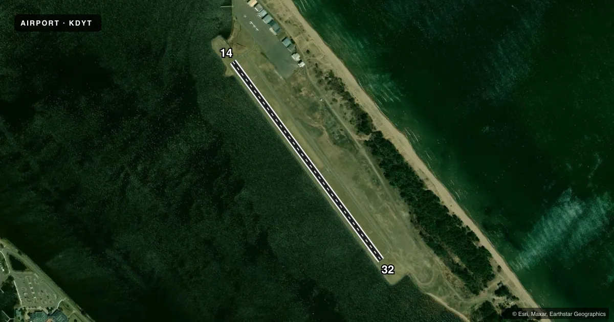
Airport sketch
Runways drawn to scale from FAA survey coordinates, rendered over satellite imagery. Not for navigation.
Approaches & charts
Services on the field
Fuel grades, oxygen, maintenance, ramp storage and lighting — as declared to the FAA by the airport operator.
Fuel & services
- Fuel
- 100LL
- Oxygen (bottled)
- Not available
- Oxygen (bulk)
- Not available
- Airframe repair
- Major
- Power plant repair
- Major
- Other services
- SALES
Ramp & ground
- Transient storage
- Tie-down
- Landing fee
- No fee published
- Customs
- Available
- Lighting schedule
- SEE RMK
- Beacon schedule
- SS-SR
- Beacon
- White / Green (civil land)(WG)
- Wind indicator
- Lighted
- Segmented circle
- No
Fuel & FBOs
Cheapest 100LL and Jet A on the field and nearby. Always confirm with the FBO before taxi.
Airport notes
Surface conditions, obstructions, local procedures, lighting outages and other notes published with each FAA cycle.
General notes
- EXTSV ACFT ACT INVOF SUW ARPT 2 NM SW.
- WIND SURFING ACT INVOF SEALANES MAY-SEP.
- BIRDS ON & INVOF ARPT.
- FOR SEAPLANE OPS BE ALERT FOR EXTSV WATER SPORT ACT IN LAKE SUPERIOR BAY.
- FOR CD CTC DULUTH APCH 218-740-5950.
Lighting notes
- ACTVT OR INCR INTST REIL RWY 14 & 32; PAPI RWY 14 & 32; MIRL RWY 14/32 - CTAF. MIRL RWY 14/32 PRESET LOW INTST SS-SR.
Fuel notes
- 100LLFUEL AVBL H24 VIA CREDIT CARD.
VFR map & nearby airports
VFR sectional. Tap any ICAO chip to open that airport.
Key facts · KDYT
Answer card- ICAO
- KDYT
- Name
- SKY HARBOR
- Location
- DULUTH, MINNESOTA
- Elevation
- 608.6 ft MSL
- Traffic pattern altitude
- 1,608.6 ft MSL (1,000 AGL)
- Control tower
- Non-towered (use CTAF)
- Total runways
- 1
- Longest runway
- 14/32 · 2,602 ft
- Published ILS approaches
- 0
- Published frequencies
- 5
- Magnetic variation
- 1°
- Current flight rules
- VFR
- Current wind
- 020° at 5 kt
- Favored runway now
- RWY 32
Sky Harbor sits in Duluth, Minnesota. The field elevation is 608.6 ft MSL. It has one runway, 14/32, which is 2,602 ft long and paved with asphalt. There is no control tower. Pattern altitude is not published, so plan on the standard 1,000 ft AGL for light piston traffic unless the current Chart Supplement says otherwise.
No ILS approaches are published here. The airport uses CTAF 122.7 and UNICOM 122.7. For clearance delivery, Duluth Approach handles that work. The published remarks also note birds on and near the airport. Windsurfing activity can show up in the sealanes from May through September. If you are working seaplane traffic nearby, keep a sharp scan over Lake Superior Bay because water sport activity can be heavy.
Sky Harbor Airport is on the field. It carries 100LL. Fuel is available 24 hours a day by credit card. Runway lighting is medium intensity on 14/32. The lights are preset to low from sunset to sunrise. Runway end identifier lights and PAPI are published on both runway ends. This is a small, active field near a busy Duluth area. Expect traffic. Watch for birds. Verify current procedures with the airport operator or the current FAA Chart Supplement before you go.