METAR & TAF KCOQ
Current METAR
Observed 11:15Z
KCOQ 271115Z AUTO 00000KT 10SM BKN008 BKN015 23/21 A2966 RMK AO2 TSNO
- Wind
- 000° @ 0 kt
- Visibility
- 10 SM
- Temp / Dew
- 23°C / 21°C
- Altimeter
- 29.66 inHg
- Clouds
- BKN
- Density alt
- 2,868 ft
- Ceiling
- 800 ft AGL
- Rules
- IFR
Airport info & contacts
Manager on record, flight service, ARTCC, attendance schedule and pattern altitude — published by the FAA and refreshed every 28 days.
Location
- From city
- 3 NM SW
- VFR sectional
- GREEN BAY
- ARTCC
- ZMP · MINNEAPOLIS
- NOTAM facility
- COQ (NOTAM-D)
Airport manager
- Name
- QUINTEN ANDERSON
- Phone
- 218-879-4911
- Address
- 125 WHEATON RD, CLOQUET MN 55720-9504
Flight service · Hours
- FSS PNM
- PRINCETON1-800-WX-BRIEF
- Attendance
- MON-SAT · 0800-1700
Frequencies
Tap any row to copy the frequency to your clipboard.
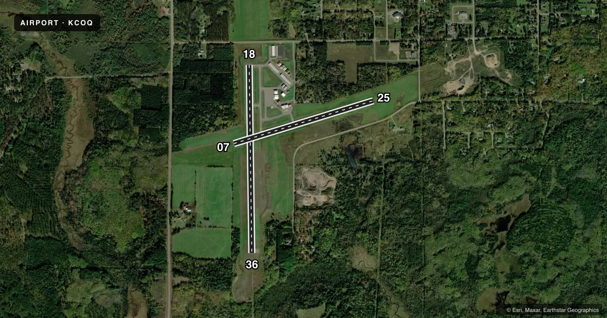
Runways & pattern
Full pagePattern entry · RWY 18
LEFT TRAFFIC| Runway | Heading (°M) | Length | Surface | Traffic |
|---|---|---|---|---|
| 18/36 | 178° / 358° | 4,002 ft | ASPH | Standard L |
| 07/25 | 72° / 252° | 3,100 ft | ASPH | Standard L |
Runway end performance
| End | TORA | TODA | ASDA | LDA | VGSI | Approach lights | Obstruction |
|---|---|---|---|---|---|---|---|
| 18 | — | — | — | — | PAPI 4-box left(3°) | — | — |
| 36 | — | — | — | — | PAPI 4-box left(3°) | ODALS | — |
Declared distances in feet. TORA = takeoff run available, TODA = takeoff distance, ASDA = accelerate-stop, LDA = landing distance.
Airport sketch
Runways drawn to scale from FAA survey coordinates, rendered over satellite imagery. Not for navigation.
Approaches & charts
Services on the field
Fuel grades, oxygen, maintenance, ramp storage and lighting — as declared to the FAA by the airport operator.
Fuel & services
- Fuel
- 100LLA
- Oxygen (bottled)
- Not available
- Oxygen (bulk)
- Not available
- Airframe repair
- Major
- Power plant repair
- Major
- Other services
- INSTR,RNTL,SALES,SURV
Ramp & ground
- Transient storage
- Tie-down
- Landing fee
- No fee published
- Customs
- Not available
- Lighting schedule
- SEE RMK
- Beacon schedule
- SS-SR
- Beacon
- White / Green (civil land)(WG)
- Wind indicator
- Lighted
- Segmented circle
- No
Fuel & FBOs
Cheapest 100LL and Jet A on the field and nearby. Always confirm with the FBO before taxi.
Airport notes
Surface conditions, obstructions, local procedures, lighting outages and other notes published with each FAA cycle.
General notes
- WILDLIFE ON & INVOF ARPT.
- FOR CD CTC DULUTH APCH AT 218-740-5950.
- NOISE ABATEMENT: AVOID OVR FLT OF SCHOOL & OFC BLDGS; 0.5 NM NW DEP END RWY 36.
Lighting notes
- ACTVT ODALS RWY 36; REIL RWY 18 & 36; PAPI RWY 18 & 36; MIRL RWY 18/36 & 07/25 - CTAF.
Fuel notes
- 100LLFUEL AVBL H24 SELF SVC VIA CREDIT CARD.
Approach & departure obstructions
- 18PREFERRED CALM WIND RWY.
Other notes
- 1FOR SVC AFT HRS CALL 218-393-2405.
VFR map & nearby airports
VFR sectional. Tap any ICAO chip to open that airport.
Key facts · KCOQ
Answer card- ICAO
- KCOQ
- Name
- CLOQUET/CARLTON COUNTY
- Location
- CLOQUET, MINNESOTA
- Elevation
- 1,279.1 ft MSL
- Traffic pattern altitude
- 2,279.1 ft MSL (1,000 AGL)
- Control tower
- Non-towered (use CTAF)
- Total runways
- 2
- Longest runway
- 18/36 · 4,002 ft
- Published ILS approaches
- 0
- Published frequencies
- 5
- Magnetic variation
- 1°
- Current flight rules
- IFR
- Current wind
- 000° at 0 kt
- Favored runway now
- –
Cloquet/Carlton County Airport sits in Cloquet, Minnesota. The field elevation is 1,279.1 ft MSL. It has two asphalt runways. The longest is 4,002 ft on runway 18/36. There is no control tower. The pattern altitude is not published. Use the standard 1,000 ft AGL for light piston traffic unless the current Chart Supplement says otherwise.
No ILS approaches are published here. Runway 18 is the preferred calm wind runway. Runway 36 has an active omnidirectional approach lighting system. Runway end identifier lights, PAPI and medium intensity runway lights are installed on both 18/36 and 07/25. That helps at night. You still want to brief the field before arrival.
Venture North Aviation is on the field. It carries 100LL and Jet A. 100LL is available 24 hours a day by self-serve with a credit card. For clearance delivery, contact Duluth Approach. The published remarks also call out noise abatement. Avoid overflying the school and office buildings 0.5 NM northwest of the departure end of runway 36. Wildlife is present on and near the airport, so keep that in mind on taxi and takeoff.