METAR & TAF KHIB
Current METAR
Observed 15:13Z
KHIB 261513Z AUTO 00000KT 3SM BR OVC002 22/22 A2985 RMK AO2 T02220222
- Wind
- 000° @ 0 kt
- Visibility
- 3 SM
- Temp / Dew
- 22°C / 22°C
- Altimeter
- 29.85 inHg
- Clouds
- OVC
- Density alt
- 2,605 ft
- Ceiling
- 200 ft AGL
- Rules
- LIFR
Airport info & contacts
Manager on record, flight service, ARTCC, attendance schedule and pattern altitude — published by the FAA and refreshed every 28 days.
Location
- From city
- 4 NM SE
- VFR sectional
- GREEN BAY
- ARTCC
- ZMP · MINNEAPOLIS
- NOTAM facility
- HIB (NOTAM-D)
Airport manager
- Name
- BARRETT ZIEMER
- Phone
- 218-440-5407
- Address
- 11038 HIGHWAY 37, HIBBING MN 55746-8203
Flight service · Hours
- FSS PNM
- PRINCETON1-800-WX-BRIEF
- Attendance
- 0400-2400
Frequencies
Tap any row to copy the frequency to your clipboard.
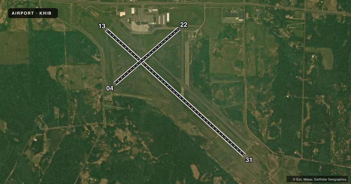
Runways & pattern
Full pagePattern entry · RWY 13
LEFT TRAFFIC| Runway | Heading (°M) | Length | Surface | Traffic |
|---|---|---|---|---|
| 13/31 | 130° / 310° | 6,758 ft | ASPH | Standard L |
| 04/22 | 47° / 227° | 3,075 ft | ASPH | Standard L |
Runway end performance
| End | TORA | TODA | ASDA | LDA | VGSI | Approach lights | Obstruction |
|---|---|---|---|---|---|---|---|
| 13 | 6,758' | 6,758' | 6,758' | 6,758' | PAPI 4-box left(3°) | MALSR | — |
| 31 | 6,758' | 6,758' | 6,758' | 6,758' | PAPI 4-box left(2.9°) | MALSR | — |
| 04 | 3,075' | 3,075' | 3,075' | 3,075' | — | — | 10', road, 310' from thr, 250' R of cntrln, slope 11 |
| 22 | 3,075' | 3,075' | 3,075' | 3,075' | — | — | 17', road, 930' from thr, 350' R of cntrln, slope 42 |
Declared distances in feet. TORA = takeoff run available, TODA = takeoff distance, ASDA = accelerate-stop, LDA = landing distance.
Airport sketch
Runways drawn to scale from FAA survey coordinates, rendered over satellite imagery. Not for navigation.
Approaches & charts
ILS · 2
Services on the field
Fuel grades, oxygen, maintenance, ramp storage and lighting — as declared to the FAA by the airport operator.
Fuel & services
- Fuel
- 100LLA
- Oxygen (bottled)
- Not available
- Oxygen (bulk)
- Not available
- Airframe repair
- Major
- Power plant repair
- Major
- Other services
- AMB,AVNCS,CHTR
Ramp & ground
- Transient storage
- Tie-down
- Hangar
- Landing fee
- Yes
- Customs
- Not available
- Lighting schedule
- SEE RMK
- Beacon schedule
- SS-SR
- Beacon
- White / Green (civil land)(WG)
- Wind indicator
- Lighted
- Segmented circle
- No
Fuel & FBOs
Cheapest 100LL and Jet A on the field and nearby. Always confirm with the FBO before taxi.
Airport notes
Surface conditions, obstructions, local procedures, lighting outages and other notes published with each FAA cycle.
General notes
- DIVD ACFT LIMITATIONS - NO INTL PSGR PROCESSING. ONLY ONE ACR GATE. LTD STERILE AREA SPACE (125 PSGRS). VENDING CONCESSIONS ONLY.
- FOR CD CTC DULUTH APCH AT 218-740-5950.
- BIRDS ON & INVOF ARPT.
- FLD CONDS UNMON 2400-0400.
- COLD TEMPERATURE AIRPORT. ALTITUDE CORRECTION REQUIRED AT OR BELOW -40C.
- TYPE I, IV DEICE FLUID AVBL. EXEC CONF ROOM, PILOT LOUNGE & AFT HRS SVC CTC 218-263-4353 (ADVND RSVN OR ADNL CTC INFO AT FBO RAMP ENTRANCE.
Lighting notes
- ACTVT OR INCR INTST MALSR RWY 13 & 31; HIRL RWY 13/31 - CTAF. PAPI RWY 13 & 31 OPR CONSLY; HIRL RWY 13/31 PRESET LOW INTST.
Runway surface & condition
- 04/22PCR VALUE: 3/F/B/X/U
- 13/31PCR VALUE: 33/F/D/X/T
- 04/22RWY 04/22 NOT AVBL FOR PART 121/PART 380 OPS WITH SKED PAX CARRYING OPS MORE THAN 9 PAX SEATS AND NON-SKED PAX CARRYING OPS MORE THAN 30 PAX SEATS. CLSD AT NGT.
Other notes
- ACR OPS NA IN EXCESS OF 15 MINS BFR OR AFT SKEDD ARR/DEP TIMES WO PRIOR CDN WITH AMGR. 24 HR PPR FOR UNSKED ACR OPS GTR THAN 30 PAX SEATS - CALL AMGR 218-262-3451.
- LDG FEE FOR ALL ACFT OVR 12500 LB.
- TRAN HEATED HGR SPACE AVBL.
VFR map & nearby airports
VFR sectional. Tap any ICAO chip to open that airport.
Key facts · KHIB
Answer card- ICAO
- KHIB
- Name
- RANGE RGNL
- Location
- HIBBING, MINNESOTA
- Elevation
- 1,353.7 ft MSL
- Traffic pattern altitude
- 2,353.7 ft MSL (1,000 AGL)
- Control tower
- Non-towered (use CTAF)
- Total runways
- 2
- Longest runway
- 13/31 · 6,758 ft
- Published ILS approaches
- 2
- Published frequencies
- 5
- Magnetic variation
- 2°
- Current flight rules
- LIFR
- Current wind
- 000° at 0 kt
- Favored runway now
- –
Range Rgnl sits in Hibbing, Minnesota. The field elevation is 1,353.7 ft MSL. It has two asphalt runways. The longest is 13/31 at 6,758 ft. There is no control tower, so expect non-towered operations on CTAF 123.0. Clearance delivery goes through Duluth Approach. The published pattern altitude is not given, so use the current Chart Supplement and standard local procedures before you arrive.
ILS service is available to runway ends 13 and 31. Runway 13/31 also has medium intensity approach lighting with runway alignment indicator lights and high intensity runway lights. The PAPI for 13 and 31 operates continuously. Runway 04/22 is 3,075 ft. It is not available for certain scheduled passenger operations. It is also closed at night.
Hibbing Fueling Facility is on the field. It carries 100LL, Jet A and Jet A Prist. The airport remarks also note cold temperature procedures. Altitude correction is required at or below minus 40 degrees Celsius. Field conditions are unmonitored from 2400 to 0400. Birds are reported on and near the airport. The airport sits at a higher elevation for the region, so plan for performance and winter density altitude effects. Check the current Chart Supplement for any noise or curfew restrictions before flying in.