METAR & TAF 07Y
07Y does not publish a METAR.
Showing the nearest reporting station: KGPZ (GRAND RAPIDS/ITASCA COUNTY-GORDON NEWSTROM FLD) · 15.6 NM away. Conditions at 07Y may differ.
METAR · KGPZ
Observed 11:56Z
KGPZ 271156Z AUTO 30011G16KT 6SM BR OVC008 23/22 A2970 RMK AO2 SLP048 T02330222 10233 20189 51005 $
- Wind
- 300° @ 11G16 kt
- Visibility
- 6 SM
- Temp / Dew
- 23°C / 22°C
- Altimeter
- 29.70 inHg
- Clouds
- OVC
- Density alt
- 2,831 ft
- Ceiling
- 800 ft AGL
- Rules
- IFR
Airport info & contacts
Manager on record, flight service, ARTCC, attendance schedule and pattern altitude — published by the FAA and refreshed every 28 days.
Location
- From city
- 2 NM S
- VFR sectional
- TWIN CITIES
- ARTCC
- ZMP · MINNEAPOLIS
- NOTAM facility
- PNM (NOTAM-D)
Airport manager
- Name
- GEORGE CASPER
- Phone
- 218-244-0440
- Address
- 125 LAKE AVE E, PO BOX 160, HILL CITY MN 55748-0160
Flight service · Hours
- FSS PNM
- PRINCETON1-800-WX-BRIEF
- Attendance
- Unattended
Frequencies
Tap any row to copy the frequency to your clipboard.
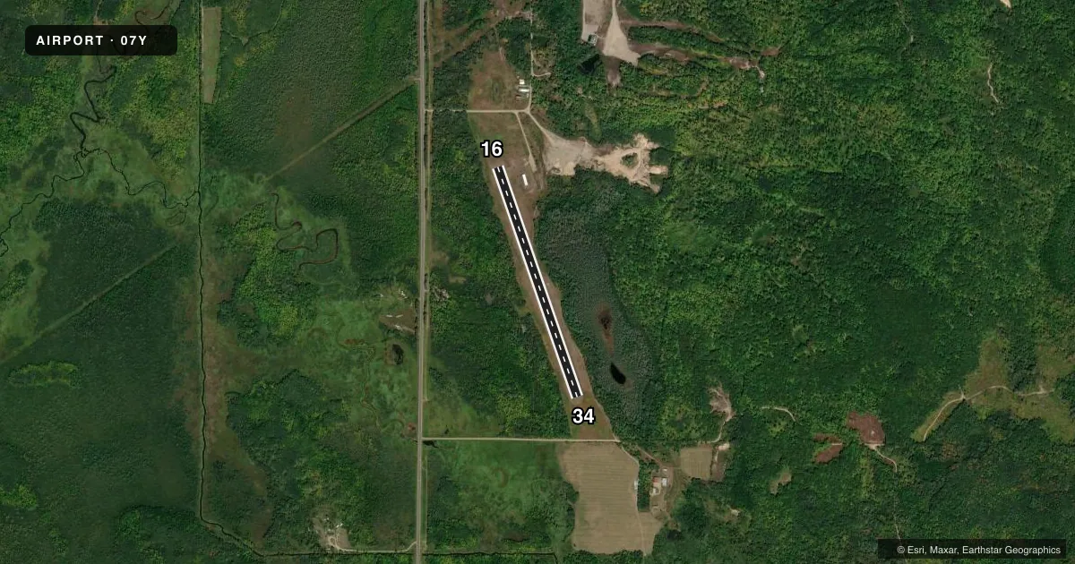
Runways & pattern
Full pagePattern entry · RWY 34
LEFT TRAFFICRunway end performance
| End | TORA | TODA | ASDA | LDA | VGSI | Approach lights | Obstruction |
|---|---|---|---|---|---|---|---|
| 16 | — | — | — | — | — | — | 50', trees, 382' from thr, 162' R of cntrln, slope 7 |
Declared distances in feet. TORA = takeoff run available, TODA = takeoff distance, ASDA = accelerate-stop, LDA = landing distance.
Airport sketch
Runways drawn to scale from FAA survey coordinates, rendered over satellite imagery. Not for navigation.
Approaches & charts
Services on the field
Fuel grades, oxygen, maintenance, ramp storage and lighting — as declared to the FAA by the airport operator.
Fuel & services
- Fuel
- Not available
Ramp & ground
- Transient storage
- Tie-down
- Landing fee
- No fee published
- Wind indicator
- Yes
- Segmented circle
- No
Fuel & FBOs
Cheapest 100LL and Jet A on the field and nearby. Always confirm with the FBO before taxi.
Airport notes
Surface conditions, obstructions, local procedures, lighting outages and other notes published with each FAA cycle.
General notes
- ARPT CLSD SS-SR.
- FOR CD CTC MINNEAPOLIS ARTCC AT 651-463-5588.
Runway surface & condition
- 16/34CLSD WINTER MONTHS.
Approach & departure obstructions
- 16RWY 16 MKD WITH YELLOW CONES.
- 34RWY 34 MKD WITH YELLOW CONES.
VFR map & nearby airports
VFR sectional. Tap any ICAO chip to open that airport.
Key facts · 07Y
Answer card- ICAO
- 07Y
- Name
- HILL CITY/QUADNA MOUNTAIN
- Location
- HILL CITY, MINNESOTA
- Elevation
- 1,289 ft MSL
- Traffic pattern altitude
- 2,289 ft MSL (1,000 AGL)
- Control tower
- Non-towered (use CTAF)
- Total runways
- 1
- Longest runway
- 16/34 · 2,902 ft
- Published ILS approaches
- 0
- Published frequencies
- 1
- Magnetic variation
- –
- Current flight rules
- IFR
- Current wind
- 300° at 11 kt
- Favored runway now
- RWY 34
07Y sits in Hill City, Minnesota. The field elevation is 1,289 ft MSL. It has one runway. Runway 16/34 is 2,902 ft of turf, so performance planning matters if you are bringing in a heavier airplane or operating on a soft surface. No tower is published. CTAF is 122.9. No ILS approaches are published.
The published pattern altitude is not listed. Use standard 1,000 ft AGL unless the current FAA Chart Supplement says otherwise. That puts the light piston pattern at about 2,289 ft MSL based on the field elevation. Verify before you fly. The airport is closed from sunset to sunrise. Runway 16/34 is also closed during the winter months. Runway 16 and Runway 34 are marked with yellow cones.
No on-field FBOs are listed, so plan for self-sufficiency and verify services before departure. For clearance delivery, Minneapolis ARTCC is the published contact. If you are coming in VFR, brief the turf surface, the daylight-only operating window and the winter closure before you launch. Hill City is in a rural area, so expect a quiet non-towered arrival. Make sure your arrival timing fits the published operating limits.