METAR & TAF KPWC
Current METAR
Observed 18:55Z
KPWC 271855Z AUTO 36012KT 10SM 30/22 A2977 RMK AO2 T02990219 $
- Wind
- 360° @ 12 kt
- Visibility
- 10 SM
- Temp / Dew
- 30°C / 22°C
- Altimeter
- 29.77 inHg
- Clouds
- Clear
- Density alt
- 3,593 ft
- Ceiling
- Unlimited
- Rules
- VFR
Airport info & contacts
Manager on record, flight service, ARTCC, attendance schedule and pattern altitude — published by the FAA and refreshed every 28 days.
Location
- From city
- 1 NM E
- VFR sectional
- TWIN CITIES
- ARTCC
- ZMP · MINNEAPOLIS
- NOTAM facility
- PWC (NOTAM-D)
Airport manager
- Name
- NICOLE COLER
- Phone
- 218-587-2440
- Address
- 200 FRONT ST N, PO BOX 87, PINE RIVER MN 56474-2303
Flight service · Hours
- FSS PNM
- PRINCETON1-800-WX-BRIEF
- Attendance
- Unattended
Frequencies
Tap any row to copy the frequency to your clipboard.
Runways & pattern
Full pagePattern entry · RWY 34
LEFT TRAFFICRunway end performance
| End | TORA | TODA | ASDA | LDA | VGSI | Approach lights | Obstruction |
|---|---|---|---|---|---|---|---|
| 16 | — | — | — | — | VASI 2-box left(3°) | — | — |
| 34 | — | — | — | — | VASI 2-box left(3°) | — | — |
Declared distances in feet. TORA = takeoff run available, TODA = takeoff distance, ASDA = accelerate-stop, LDA = landing distance.
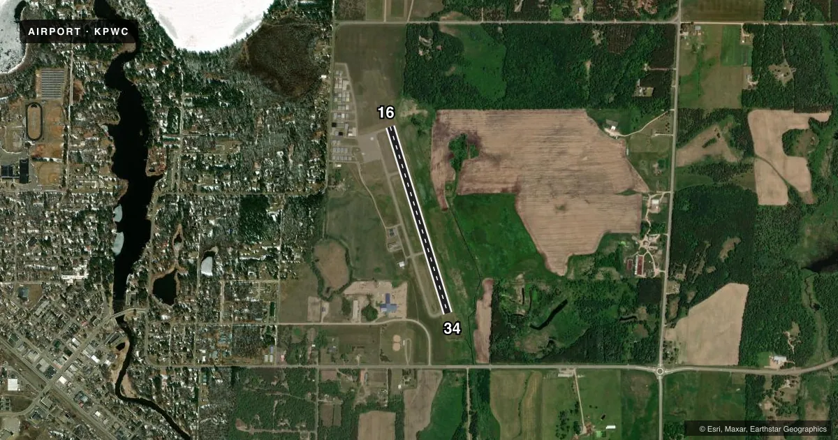
Airport sketch
Runways drawn to scale from FAA survey coordinates, rendered over satellite imagery. Not for navigation.
Approaches & charts
Services on the field
Fuel grades, oxygen, maintenance, ramp storage and lighting — as declared to the FAA by the airport operator.
Fuel & services
- Fuel
- 100LL
- Airframe repair
- Not available
- Power plant repair
- Not available
- Other services
- SALES
Ramp & ground
- Transient storage
- Tie-down
- Landing fee
- No fee published
- Lighting schedule
- SEE RMK
- Wind indicator
- Lighted
- Segmented circle
- No
Fuel & FBOs
Cheapest 100LL and Jet A on the field and nearby. Always confirm with the FBO before taxi.
Airport notes
Surface conditions, obstructions, local procedures, lighting outages and other notes published with each FAA cycle.
General notes
- CFM SNOW REMOVAL & WINTER CONDS CALL 218-821-3521.
- ULTRALIGHTS ON & INVOF ARPT.
- DEER & WATERFOWL ON & INVOF ARPT.
- FOR CD CTC MINNEAPOLIS ARTCC AT 651-463-5588.
Lighting notes
- ACTVT OR INCR INTST REIL RWY 16 & 34; VASI RWY 16 & 34; MIRL RWY 16/34 - CTAF. MIRL RWY 16/34 PRESET MED INTST.
Fuel notes
- 100LLFUEL AVBL H24 SELF SER VIA CREDIT CARD. AFT HRS CALL 218-821-3521.
Approach & departure obstructions
- 34CALM WIND RWY.
Other notes
- 1FOR EMERG CALL 218-821-3521.
VFR map & nearby airports
VFR sectional. Tap any ICAO chip to open that airport.
Key facts · KPWC
Answer card- ICAO
- KPWC
- Name
- PINE RIVER RGNL
- Location
- PINE RIVER, MINNESOTA
- Elevation
- 1,295.6 ft MSL
- Traffic pattern altitude
- 2,295.6 ft MSL (1,000 AGL)
- Control tower
- Non-towered (use CTAF)
- Total runways
- 1
- Longest runway
- 16/34 · 3,000 ft
- Published ILS approaches
- 0
- Published frequencies
- 1
- Magnetic variation
- 3°
- Current flight rules
- VFR
- Current wind
- 360° at 12 kt
- Favored runway now
- RWY 34
Pine River Regional Airport (KPWC) sits in Pine River, Minnesota. Field elevation is 1,295.6 ft MSL. The airport has one runway. Runway 16/34 is 3,000 ft long and asphalt. There is no control tower. CTAF is 122.9.
No ILS approaches are published here. The pattern altitude is not published, so use the standard 1,000 ft AGL for light piston operations unless the current Chart Supplement says otherwise. Runway 16 and 34 have visual approach slope indicators. Medium intensity runway lights are on runway 16/34 and are controlled by CTAF. Runway end identifier lights are also installed on both ends.
Pine River Regional Airport is the on-field FBO. It carries 100LL. Fuel is available 24 hours a day through self-service credit card. Call the airport at 218-821-3521 if you need after-hours help or want to confirm snow removal and winter conditions. Ultralights operate on and near the airport. Deer and waterfowl are also reported in the area, so keep a sharp scan on departure and arrival. Runway 34 is the calm wind runway. For clearance delivery, contact Minneapolis ARTCC at 651-463-5588.