METAR & TAF KAIT
Current METAR
Observed 12:55Z
KAIT 271255Z AUTO 27003KT 10SM CLR 24/21 A2970 RMK AO2
- Wind
- 270° @ 3 kt
- Visibility
- 10 SM
- Temp / Dew
- 24°C / 21°C
- Altimeter
- 29.70 inHg
- Clouds
- CLR
- Density alt
- 2,848 ft
- Ceiling
- Unlimited
- Rules
- VFR
Airport info & contacts
Manager on record, flight service, ARTCC, attendance schedule and pattern altitude — published by the FAA and refreshed every 28 days.
Location
- From city
- 2 NM NE
- VFR sectional
- TWIN CITIES
- ARTCC
- ZMP · MINNEAPOLIS
- NOTAM facility
- AIT (NOTAM-D)
Airport manager
- Name
- JENNIFER THOMPSON
- Phone
- 218-927-2527
- Address
- 109 1ST AVE NW, AITKIN MN 56431-1397
Flight service · Hours
- FSS PNM
- PRINCETON1-800-WX-BRIEF
- Attendance
- APR-OCT · 0800-1700
- NOV-MAR · MON-FRI · 0900-1700
Frequencies
Tap any row to copy the frequency to your clipboard.
Runways & pattern
Full pagePattern entry · RWY 26
LEFT TRAFFIC| Runway | Heading (°M) | Length | Surface | Traffic |
|---|---|---|---|---|
| 16/34 | 164° / 344° | 4,000 ft | ASPH | Standard L |
| 08/26Favored | 87° / 267° | 3,123 ft | TURF | Standard L |
Runway end performance
| End | TORA | TODA | ASDA | LDA | VGSI | Approach lights | Obstruction |
|---|---|---|---|---|---|---|---|
| 16 | — | — | — | — | PAPI 4-box left(3°) | — | — |
| 34 | — | — | — | — | PAPI 4-box left(3°) | — | 96', tree, 1644' from thr, 445' R of cntrln, slope 15 |
| 08 | 3,123' | 3,123' | 3,123' | 2,883' | — | — | 38', trees, 676' from thr, 130' R of cntrln, slope 17 |
| 26 | — | — | — | — | — | — | 45', trees, 819' from thr, 64' R of cntrln, slope 18 |
Declared distances in feet. TORA = takeoff run available, TODA = takeoff distance, ASDA = accelerate-stop, LDA = landing distance.
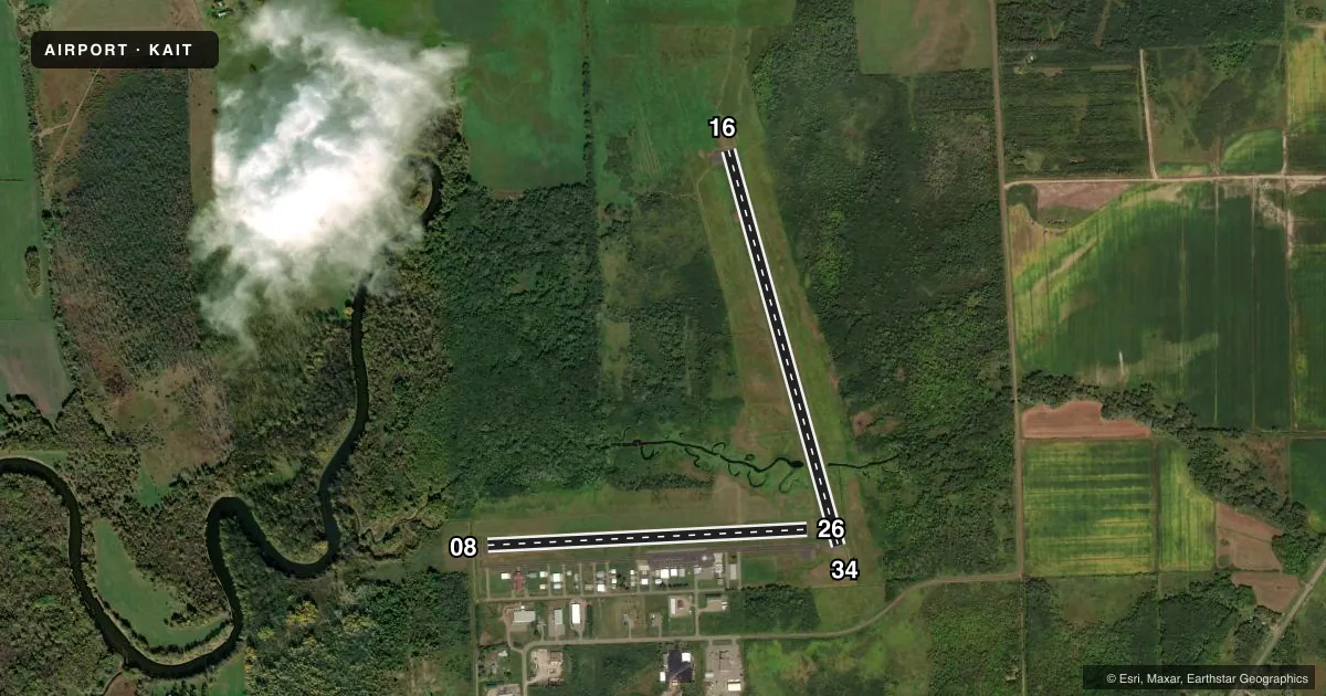
Airport sketch
Runways drawn to scale from FAA survey coordinates, rendered over satellite imagery. Not for navigation.
Approaches & charts
Services on the field
Fuel grades, oxygen, maintenance, ramp storage and lighting — as declared to the FAA by the airport operator.
Fuel & services
- Fuel
- 100LLA
- Oxygen (bottled)
- Low pressure
- Oxygen (bulk)
- Not available
- Airframe repair
- Major
- Power plant repair
- Major
- Other services
- AVNCS,SALES
Ramp & ground
- Transient storage
- Tie-down
- Hangar
- Landing fee
- No fee published
- Customs
- Not available
- Lighting schedule
- SEE RMK
- Beacon schedule
- SS-SR
- Beacon
- White / Green (civil land)(WG)
- Wind indicator
- Lighted
- Segmented circle
- No
Fuel & FBOs
Cheapest 100LL and Jet A on the field and nearby. Always confirm with the FBO before taxi.
Airport notes
Surface conditions, obstructions, local procedures, lighting outages and other notes published with each FAA cycle.
General notes
- GCO AVBL ON FREQ 121.725 THRU ZMP ARTCC AND PNM FSS.
- FOR CD IF UNA VIA GCO CTC MINNEAPOLIS ARTCC AT 651-463-5588.
Lighting notes
- MIRL RWY 16/34 PRESET LOW INTST; ACTVT OR INCR INTST REIL RWY 16 & 34; PAPI RWY 16 & 34; MIRL RWY 16/34 - CTAF
Fuel notes
- 100LL100LL & JET A AVBL H24 VIA CREDIT CARD. FOR SVC CALL 218-839-1067 OR 218-839-6488.
Runway surface & condition
- 08/26SKI EQUIPPED ACFT ONLY NOV-APR, CALL 218-927-4104 FOR RY CONDS.
Approach & departure obstructions
- 16CALM WIND RWY.
- 08YELLOW CONES.
- 26YELLOW CONES.
Other notes
- MANAGERARPT OPS DAY 218-839-1067; NGT 218-851-4502.
VFR map & nearby airports
VFR sectional. Tap any ICAO chip to open that airport.
Key facts · KAIT
Answer card- ICAO
- KAIT
- Name
- AITKIN MUNI/STEVE KURTZ FLD
- Location
- AITKIN, MINNESOTA
- Elevation
- 1,206 ft MSL
- Traffic pattern altitude
- 2,206 ft MSL (1,000 AGL)
- Control tower
- Non-towered (use CTAF)
- Total runways
- 2
- Longest runway
- 16/34 · 4,000 ft
- Published ILS approaches
- 0
- Published frequencies
- 2
- Magnetic variation
- 0°
- Current flight rules
- VFR
- Current wind
- 270° at 3 kt
- Favored runway now
- RWY 26
Aitkin Muni/Steve Kurtz Fld (KAIT) sits in Aitkin, Minnesota at 1,206 ft MSL. It has two runways. The longest is 16/34 at 4,000 ft asphalt. Runway 08/26 is 3,123 ft turf. There is no control tower. CTAF and UNICOM are both 123.05.
No ILS approaches are published here. Pattern altitude is not published, so use the standard 1,000 ft AGL for light piston traffic unless the current FAA Chart Supplement says otherwise. That puts the traffic pattern at 2,206 ft MSL based on the field elevation. Runway 16 is the calm wind runway. Runway 08 and Runway 26 are marked with yellow cones. Runway 08/26 is for ski-equipped aircraft only from November through April, so check runway condition before you plan on using the turf strip in winter.
Adventure North Flying Service is on the field. It carries 100LL and Jet A Prist. Fuel is available 24 hours a day by credit card. The runway 16/34 lights are controlled by CTAF. They are preset to low intensity. PAPI is installed on runways 16 and 34. If you need current runway condition or airport operations info, call the airport or the FBO directly before departure.