METAR & TAF KEVM
Current METAR
Observed 15:28Z
KEVM 271528Z AUTO 08004KT 10SM OVC008 21/19 RMK AO1
- Wind
- 080° @ 4 kt
- Visibility
- 10 SM
- Temp / Dew
- 21°C / 19°C
- Altimeter
- —
- Clouds
- OVC
- Density alt
- 2,426 ft
- Ceiling
- 800 ft AGL
- Rules
- IFR
Airport info & contacts
Manager on record, flight service, ARTCC, attendance schedule and pattern altitude — published by the FAA and refreshed every 28 days.
Location
- From city
- 3 NM SE
- VFR sectional
- GREEN BAY
- ARTCC
- ZMP · MINNEAPOLIS
- NOTAM facility
- EVM (NOTAM-D)
Airport manager
- Name
- TED LEWIS
- Phone
- 218-748-1271
- Address
- 413 PIERCE STREET, EVELETH MN 04094-4094
Flight service · Hours
- FSS PNM
- PRINCETON1-800-WX-BRIEF
- Attendance
- Unattended
Frequencies
Tap any row to copy the frequency to your clipboard.
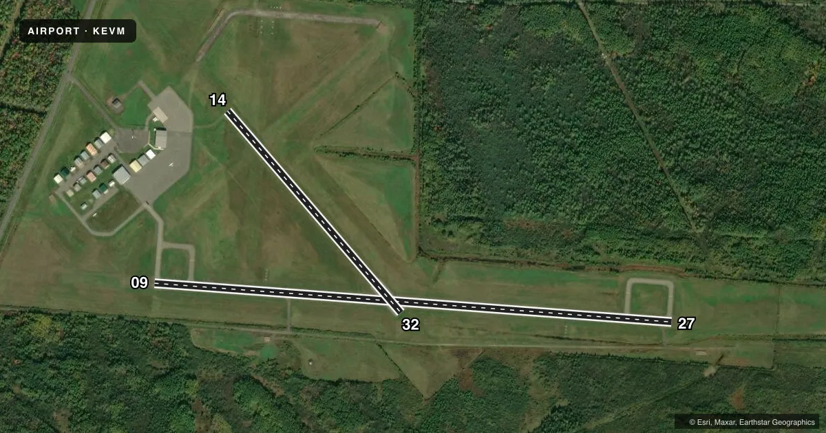
Runways & pattern
Full pagePattern entry · RWY 09
LEFT TRAFFIC| Runway | Heading (°M) | Length | Surface | Traffic |
|---|---|---|---|---|
| 09/27Favored | 94° / 274° | 4,000 ft | ASPH | Standard L |
| 14/32 | 139° / 319° | 2,050 ft | TURF | Standard L |
Runway end performance
| End | TORA | TODA | ASDA | LDA | VGSI | Approach lights | Obstruction |
|---|---|---|---|---|---|---|---|
| 09 | — | — | — | — | PAPI 4-box left(3°) | — | — |
| 27 | — | — | — | — | PAPI 4-box left(3°) | — | — |
Declared distances in feet. TORA = takeoff run available, TODA = takeoff distance, ASDA = accelerate-stop, LDA = landing distance.
Airport sketch
Runways drawn to scale from FAA survey coordinates, rendered over satellite imagery. Not for navigation.
Approaches & charts
Services on the field
Fuel grades, oxygen, maintenance, ramp storage and lighting — as declared to the FAA by the airport operator.
Fuel & services
- Fuel
- 100LLA
- Oxygen (bottled)
- Not available
- Oxygen (bulk)
- Not available
- Airframe repair
- Not available
- Power plant repair
- Not available
Ramp & ground
- Transient storage
- Tie-down
- Landing fee
- No fee published
- Customs
- Not available
- Lighting schedule
- SEE RMK
- Beacon schedule
- SS-SR
- Beacon
- White / Green (civil land)(WG)
- Wind indicator
- Lighted
- Segmented circle
- No
Fuel & FBOs
Cheapest 100LL and Jet A on the field and nearby. Always confirm with the FBO before taxi.
Airport notes
Surface conditions, obstructions, local procedures, lighting outages and other notes published with each FAA cycle.
General notes
- DEER & BIRDS ON & INVOF ARPT.
- PAVEMENT HEAVING ON RAMP NEAR HNGR.
- FOR CD CTC DULUTH APCH AT 218-740-5950.
Lighting notes
- ACTVT OR INCR INTST REIL RWY 27; PAPI RWY 09 & 27; MIRL RWY 09/27 & 14/32 - CTAF. MIRL RWY 09/27 & 14/32 PRESET LOW INTST.
Fuel notes
- 100LLSELF SERVE JET A AND AVGAS.
Runway surface & condition
- 14/32NOT PLOWED WINTER MONTHS; USBL WITH SKIS.
Other notes
- OWNERCITY OF VIRGINIA CITY CLERK, 327 1ST ST S, VIRGINIA, MN 55792-2623.
- OWNERCITY OF VIRGINIA 218-748-7500.
VFR map & nearby airports
VFR sectional. Tap any ICAO chip to open that airport.
Key facts · KEVM
Answer card- ICAO
- KEVM
- Name
- EVELETH/VIRGINIA MUNI
- Location
- EVELETH, MINNESOTA
- Elevation
- 1,376 ft MSL
- Traffic pattern altitude
- 2,376 ft MSL (1,000 AGL)
- Control tower
- Non-towered (use CTAF)
- Total runways
- 2
- Longest runway
- 09/27 · 4,000 ft
- Published ILS approaches
- 0
- Published frequencies
- 4
- Magnetic variation
- 0°
- Current flight rules
- IFR
- Current wind
- 080° at 4 kt
- Favored runway now
- RWY 09
Eveleth/Virginia Muni is in Eveleth, Minnesota. Field elevation is 1,376 ft MSL. The airport has two runways. The longest is 09/27 at 4,000 ft asphalt. Runway 14/32 is 2,050 ft turf. There is no control tower. Pattern altitude is not published, so plan on the standard 1,000 ft AGL for light piston traffic unless the current Chart Supplement says otherwise.
No ILS approaches are published here. CTAF and UNICOM are both 122.7. Duluth Approach handles approach and departure on 125.45 and 233.7. For clearance delivery, the published remark points pilots to Duluth Approach. The on-field FBO is Eveleth-Virginia Municipal Airport. It carries 100LL and Jet A. Self-serve fuel is available.
A few field notes matter here. Runway 27 has runway end identifier lights with increased activity or intensity. Runways 09 and 27 have PAPI. Medium intensity runway lights are on both runways and are controlled by CTAF. Runway 14/32 is not plowed in winter and can be used with skis. Deer and birds are reported on and near the airport. There is also pavement heaving on the ramp near the hangar. First-time visitors should keep that in mind during taxi and parking.