METAR & TAF KTWM
Current METAR
Observed 21:55Z
KTWM 272155Z AUTO 07007KT 10SM OVC006 16/15 A2983 RMK AO2
- Wind
- 070° @ 7 kt
- Visibility
- 10 SM
- Temp / Dew
- 16°C / 15°C
- Altimeter
- 29.83 inHg
- Clouds
- OVC
- Density alt
- 1,562 ft
- Ceiling
- 600 ft AGL
- Rules
- IFR
Airport info & contacts
Manager on record, flight service, ARTCC, attendance schedule and pattern altitude — published by the FAA and refreshed every 28 days.
Location
- From city
- 4 NM NW
- VFR sectional
- GREEN BAY
- ARTCC
- ZMP · MINNEAPOLIS
- NOTAM facility
- TWM (NOTAM-D)
Airport manager
- Name
- CASEY KOMAREK
- Phone
- 218-510-0628
- Address
- 522 1ST AVE, TWO HARBORS MN 55616-1535
Flight service · Hours
- FSS PNM
- PRINCETON1-800-WX-BRIEF
- Attendance
- MON-FRI · 0800-1400
Frequencies
Tap any row to copy the frequency to your clipboard.
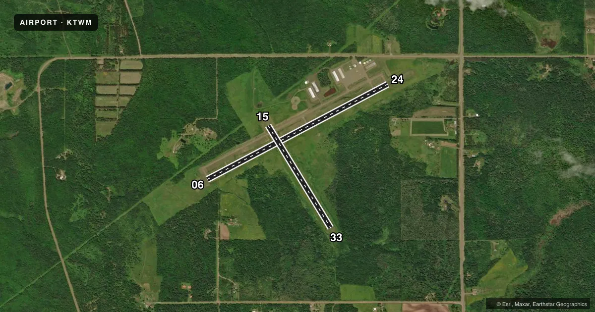
Runways & pattern
Full pagePattern entry · RWY 06
LEFT TRAFFIC| Runway | Heading (°M) | Length | Surface | Traffic |
|---|---|---|---|---|
| 06/24Favored | 61° / 241° | 4,400 ft | ASPH | Standard L |
| 15/33 | 148° / 328° | 2,581 ft | TURF | Standard L |
Runway end performance
| End | TORA | TODA | ASDA | LDA | VGSI | Approach lights | Obstruction |
|---|---|---|---|---|---|---|---|
| 06 | — | — | — | — | PAPI 4-box left(3°) | — | — |
| 24 | — | — | — | — | PAPI 4-box left(3°) | — | — |
| 33 | — | — | — | — | — | — | 9', trees, 113' from thr, 99' R of cntrln, slope 12 |
Declared distances in feet. TORA = takeoff run available, TODA = takeoff distance, ASDA = accelerate-stop, LDA = landing distance.
Airport sketch
Runways drawn to scale from FAA survey coordinates, rendered over satellite imagery. Not for navigation.
Approaches & charts
Services on the field
Fuel grades, oxygen, maintenance, ramp storage and lighting — as declared to the FAA by the airport operator.
Fuel & services
- Fuel
- 100LLAMOGAS
- Oxygen (bottled)
- Not available
- Oxygen (bulk)
- Not available
- Airframe repair
- Major
- Power plant repair
- Minor
- Other services
- SALES,SURV
Ramp & ground
- Transient storage
- Tie-down
- Hangar
- Landing fee
- No fee published
- Customs
- Not available
- Lighting schedule
- SEE RMK
- Beacon schedule
- SS-SR
- Beacon
- White / Green (civil land)(WG)
- Wind indicator
- Lighted
- Segmented circle
- Yes
Fuel & FBOs
Cheapest 100LL and Jet A on the field and nearby. Always confirm with the FBO before taxi.
Airport notes
Surface conditions, obstructions, local procedures, lighting outages and other notes published with each FAA cycle.
General notes
- GCO AVBL ON FREQ 121.725 THRU DLH CD & FLT SVCS.
- FOR CD CTC DULUTH APCH AT 218-740-5950.
Lighting notes
- MIRL RWY 6/24 PRESET TO LOW SS-SR. INCR INTST AND ACTVT REIL RWY 06, 24; PAPI RWY 6, 24 - CTAF.
Fuel notes
- 100LLFUEL AVBL 24 HRS WITH CREDIT CARD.
Runway surface & condition
- 15/33CLSD WINTER MONTHS EXCEPT SKI EQUIPPED ACFT.
Approach & departure obstructions
- 15RY 15/33 MKD WITH YELLOW CONES.
Other notes
- 1FOR SVC AFT HRS CALL (218) 830-0470
VFR map & nearby airports
VFR sectional. Tap any ICAO chip to open that airport.
Key facts · KTWM
Answer card- ICAO
- KTWM
- Name
- RICHARD B HELGESON
- Location
- TWO HARBORS, MINNESOTA
- Elevation
- 1,073.1 ft MSL
- Traffic pattern altitude
- 2,073.1 ft MSL (1,000 AGL)
- Control tower
- Non-towered (use CTAF)
- Total runways
- 2
- Longest runway
- 06/24 · 4,400 ft
- Published ILS approaches
- 0
- Published frequencies
- 3
- Magnetic variation
- 1°
- Current flight rules
- IFR
- Current wind
- 070° at 7 kt
- Favored runway now
- RWY 06
Richard B Helgeson Airport sits in Two Harbors, Minnesota. Field elevation is 1,073.1 ft MSL. The airport has two runways. The longest is 06/24 at 4,400 ft. Runway 15/33 is 2,581 ft of turf. There is no control tower. Clearance delivery is handled through Duluth Approach. The published frequencies include Duluth approach and departure plus CTAF 122.9. No ILS approaches are published here.
Pattern altitude is not published. Use the standard 1,000 ft AGL pattern unless the current Chart Supplement or local traffic calls for something different. The on-field FBO is Two Harbors Municipal Airport. It carries 100LL, Jet A Prist and MOGAS. Fuel is available 24 hours with credit card. After hours service is listed by phone.
A few field details matter here. Runway 15/33 is closed in winter except for ski-equipped aircraft. Runways 15 and 33 are marked with yellow cones. Runway 06/24 lighting is preset low from sunset to sunrise. Pilots can raise the intensity and turn on runway end identifier lights and PAPI on 06 and 24 through the CTAF. This is a good field to brief before arrival, especially if you are planning a night stop or a winter landing.