METAR & TAF KSUW
Current METAR
Observed 17:15Z
KSUW 271715Z AUTO 08010G16KT 10SM OVC005 15/14 A2977 RMK AO2 T01500137
- Wind
- 080° @ 10G16 kt
- Visibility
- 10 SM
- Temp / Dew
- 15°C / 14°C
- Altimeter
- 29.77 inHg
- Clouds
- OVC
- Density alt
- 1,022 ft
- Ceiling
- 500 ft AGL
- Rules
- IFR
Airport info & contacts
Manager on record, flight service, ARTCC, attendance schedule and pattern altitude — published by the FAA and refreshed every 28 days.
Location
- From city
- 3 NM S
- VFR sectional
- GREEN BAY
- ARTCC
- ZMP · MINNEAPOLIS
- NOTAM facility
- SUW (NOTAM-D)
Airport manager
- Name
- CALVIN KRAMP
- Phone
- 715-394-0282
- Address
- 4804 HAMMOND AVE, SUPERIOR WI 54880
Flight service · Hours
- FSS GRB
- GREEN BAY1-800-WX-BRIEF
- Attendance
- 0800-DUSK
Frequencies
Tap any row to copy the frequency to your clipboard.
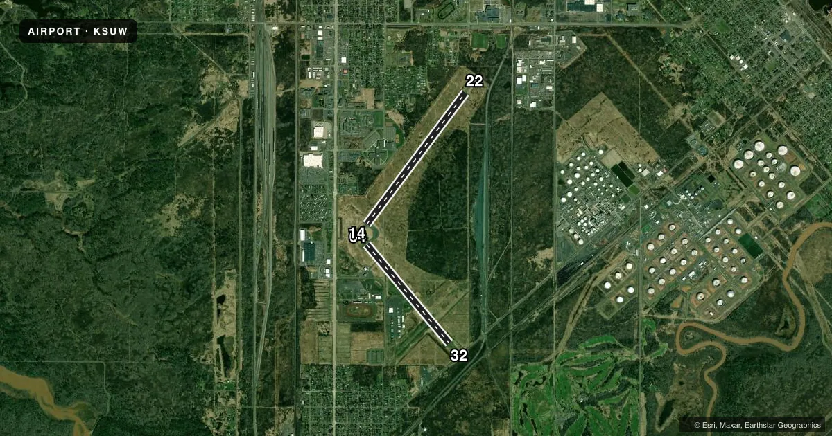
Runways & pattern
Full pagePattern entry · RWY 04
LEFT TRAFFIC| Runway | Heading (°M) | Length | Surface | Traffic |
|---|---|---|---|---|
| 04/22Favored | 36° / 216° | 5,100 ft | ASPH | Standard L |
| 14/32 | 139° / 319° | 4,001 ft | ASPH | Standard L |
Runway end performance
| End | TORA | TODA | ASDA | LDA | VGSI | Approach lights | Obstruction |
|---|---|---|---|---|---|---|---|
| 04 | — | — | — | — | PAPI 4-box left(3°) | — | — |
| 32 | — | — | — | — | PAPI 4-box left(4°) | — | — |
Declared distances in feet. TORA = takeoff run available, TODA = takeoff distance, ASDA = accelerate-stop, LDA = landing distance.
Airport sketch
Runways drawn to scale from FAA survey coordinates, rendered over satellite imagery. Not for navigation.
Approaches & charts
Services on the field
Fuel grades, oxygen, maintenance, ramp storage and lighting — as declared to the FAA by the airport operator.
Fuel & services
- Fuel
- 100LLA+
- Oxygen (bottled)
- Not available
- Oxygen (bulk)
- Not available
- Airframe repair
- Major
- Power plant repair
- Major
- Other services
- INSTR,PAJA,RNTL
Ramp & ground
- Transient storage
- Tie-down
- Hangar
- Landing fee
- No fee published
- Customs
- Not available
- Lighting schedule
- SEE RMK
- Beacon schedule
- SS-SR
- Beacon
- White / Green (civil land)(WG)
- Wind indicator
- Lighted
- Segmented circle
- No
Fuel & FBOs
Cheapest 100LL and Jet A on the field and nearby. Always confirm with the FBO before taxi.
Airport notes
Surface conditions, obstructions, local procedures, lighting outages and other notes published with each FAA cycle.
General notes
- DEER ON & VICINITY OF ARPT.
- FOR CD CTC DULUTH APCH AT 218-740-5950.
Lighting notes
- ACTVT REIL RWY 04, 14, & 32 - CTAF. MIRL RWY 04/22 & RWY 14/32 PRESET TO LOW SS-SR, TO INCR INTST & ACTVT - CTAF.
Fuel notes
- 100LL24 HR FUEL AVBL WITH CREDIT CARD.
VFR map & nearby airports
VFR sectional. Tap any ICAO chip to open that airport.
Key facts · KSUW
Answer card- ICAO
- KSUW
- Name
- RICHARD I BONG
- Location
- SUPERIOR, WISCONSIN
- Elevation
- 674.4 ft MSL
- Traffic pattern altitude
- 1,674.4 ft MSL (1,000 AGL)
- Control tower
- Non-towered (use CTAF)
- Total runways
- 2
- Longest runway
- 04/22 · 5,100 ft
- Published ILS approaches
- 0
- Published frequencies
- 5
- Magnetic variation
- 1°
- Current flight rules
- IFR
- Current wind
- 080° at 10 kt
- Favored runway now
- RWY 04
Richard I Bong Airport sits in Superior, Wisconsin. Field elevation is 674.4 ft MSL. The airport has two asphalt runways. The longest is 5,100 ft on 04/22. The other runway is 14/32 at 4,001 ft. There is no control tower. Clearance delivery is handled by Duluth Approach. No ILS approaches are published here.
The pattern altitude is not published. Use the standard 1,000 ft AGL for light piston traffic unless the current Chart Supplement says otherwise. That puts the traffic pattern at about 1,674.4 ft MSL based on the field elevation. Superior Flying Services is on the field. It carries 100LL and Jet A Prist. 24-hour fuel is available with credit card. Runway end identifier lights on 04, 14 and 32 are activated by CTAF. The medium intensity runway lights on both runways are preset low from sunset to sunrise. CTAF can be used to increase intensity and activate the lights. Deer are reported on and near the airport. Expect wildlife on taxi and takeoff rolls. For any current noise or operational restrictions, check the current FAA Chart Supplement before you go.