METAR & TAF KASX
Current METAR
Observed 13:05Z
KASX 271305Z AUTO 03014G28KT 4SM -RA BR BKN004 OVC011 16/15 A2973 RMK AO2 PK WND 03028/1256 LTG DSNT E RAB03 CIG 003V009 P0000 T01560150
- Wind
- 030° @ 14G28 kt
- Visibility
- 4 SM
- Temp / Dew
- 16°C / 15°C
- Altimeter
- 29.73 inHg
- Clouds
- OVC
- Density alt
- 1,380 ft
- Ceiling
- 400 ft AGL
- Rules
- LIFR
Airport info & contacts
Manager on record, flight service, ARTCC, attendance schedule and pattern altitude — published by the FAA and refreshed every 28 days.
Location
- From city
- 2 NM SW
- VFR sectional
- GREEN BAY
- ARTCC
- ZMP · MINNEAPOLIS
- NOTAM facility
- ASX (NOTAM-D)
Airport manager
- Name
- ANDREW KUNDEL
- Phone
- 715-682-7070
- Address
- 50511 STATE HIGHWAY 112, ASHLAND WI 54806
Flight service · Hours
- FSS GRB
- GREEN BAY1-800-WX-BRIEF
- Attendance
- MON-FRI · 0800-1600
Frequencies
Tap any row to copy the frequency to your clipboard.
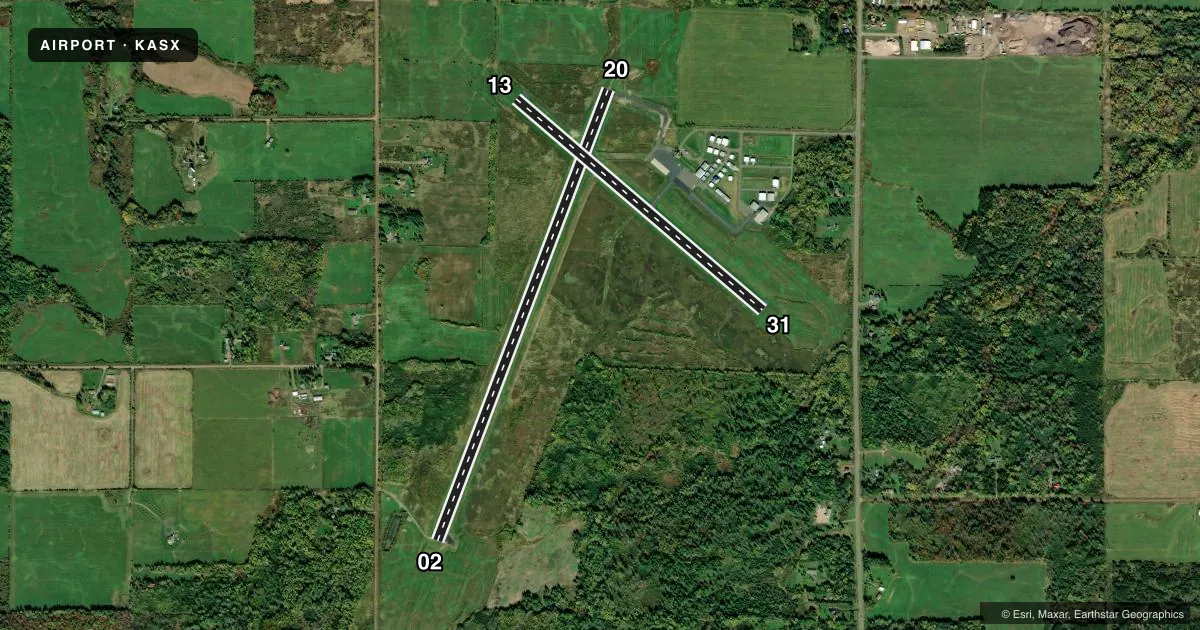
Runways & pattern
Full pagePattern entry · RWY 02
LEFT TRAFFIC| Runway | Heading (°M) | Length | Surface | Traffic |
|---|---|---|---|---|
| 02/20Favored | 19° / 199° | 5,197 ft | ASPH | Standard L |
| 13/31 | 129° / 309° | 3,498 ft | ASPH | Standard L |
Runway end performance
| End | TORA | TODA | ASDA | LDA | VGSI | Approach lights | Obstruction |
|---|---|---|---|---|---|---|---|
| 02 | — | — | — | — | PAPI 4-box left(3°) | — | 69', trees, 2215' from thr, 520' R of cntrln, slope 29 |
| 20 | — | — | — | — | PAPI 4-box right(3°) | — | — |
| 13 | — | — | — | — | — | — | 8', fence, 200' from thr, 220' R of cntrln, slope 0 |
| 31 | — | — | — | — | PAPI 2-box left(3°) | — | 49', trees, 1135' from thr, 340' R of cntrln, slope 19 |
Declared distances in feet. TORA = takeoff run available, TODA = takeoff distance, ASDA = accelerate-stop, LDA = landing distance.
Airport sketch
Runways drawn to scale from FAA survey coordinates, rendered over satellite imagery. Not for navigation.
Approaches & charts
ILS · 1
Services on the field
Fuel grades, oxygen, maintenance, ramp storage and lighting — as declared to the FAA by the airport operator.
Fuel & services
- Fuel
- 100LLA+
- Oxygen (bottled)
- Not available
- Oxygen (bulk)
- Not available
- Airframe repair
- Not available
- Power plant repair
- Not available
- Other services
- INSTR
Ramp & ground
- Transient storage
- Tie-down
- Hangar
- Landing fee
- No fee published
- Customs
- Not available
- Lighting schedule
- SEE RMK
- Beacon schedule
- SS-SR
- Beacon
- White / Green (civil land)(WG)
- Wind indicator
- Lighted
- Segmented circle
- No
Fuel & FBOs
Cheapest 100LL and Jet A on the field and nearby. Always confirm with the FBO before taxi.
Airport notes
Surface conditions, obstructions, local procedures, lighting outages and other notes published with each FAA cycle.
General notes
- DEER & OTR WILDLIFE ON & INVOF ARPT. HVY BIRD ACT SPRING & SUMMER MONTHS.
- ACFT OVER 4000 LBS MUST STOP OR PARK ON CONC; ALL OTR ACFT PARK ON ASPH.
- GCO AVBL ON FREQ 122.25 THRU FLT SVCS.
- FOR CD IF UNA TO CTC ON FSS FREQ, CTC MINNEAPOLIS ARTCC AT 651-463-5588.
Lighting notes
- MIRL RWY 02/20 PRESET TO LOW SS-SR; TO INCR INTST AND ACTVT REIL RWY 02 & 20; PAPI RWY 02, 20, & 31; MIRL RWY 02/20 & 13/31 - CTAF.
Fuel notes
- 100LLJET A+ PPR CTC AMGR 715-682-7070, AFT HRS CALL 715-292-7070. 24 HR SELF SERVE 100LL.
Runway surface & condition
- 02/20PCR VALUE: 160/F/D/X/T
Approach & departure obstructions
- 13CTLNG OBSTN EXCEEDS A 45 DEG SLP.
Other notes
- THIS AIRPORT HAS BEEN SURVEYED BY THE NATIONAL GEODETIC SURVEY.
- 1FOR SVC AFTER HRS CALL 715-292-7070.
VFR map & nearby airports
VFR sectional. Tap any ICAO chip to open that airport.
Key facts · KASX
Answer card- ICAO
- KASX
- Name
- JOHN F KENNEDY MEML
- Location
- ASHLAND, WISCONSIN
- Elevation
- 826.5 ft MSL
- Traffic pattern altitude
- 1,826.5 ft MSL (1,000 AGL)
- Control tower
- Non-towered (use CTAF)
- Total runways
- 2
- Longest runway
- 02/20 · 5,197 ft
- Published ILS approaches
- 1
- Published frequencies
- 2
- Magnetic variation
- 2°
- Current flight rules
- LIFR
- Current wind
- 030° at 14 kt
- Favored runway now
- RWY 02
John F Kennedy Meml Airport sits in Ashland, Wisconsin. The field elevation is 826.5 ft MSL. It has two asphalt runways. The longest is runway 02/20 at 5,197 ft. There is no control tower, so plan on CTAF and UNICOM 122.8 for local traffic. The published pattern altitude is not listed, so use the standard 1,000 ft AGL for light piston traffic unless the current FAA Chart Supplement says otherwise.
Runway 02 has an ILS approach. The airport also has PAPI on runways 02, 20 and 31. Runway lighting is CTAF controlled. The 02/20 lights come up low from sunset to sunrise. Then you can use CTAF to raise intensity and turn on runway end identifier lights. That matters on a night arrival. The field also has 24-hour self-serve 100LL. Jet A is available with prior permission. John F. Kennedy Memorial Airport is the on-field FBO. It carries 100LL and Jet A Prist.
Watch for deer and other wildlife near the airport. Heavy bird activity is reported in spring and summer. Runway 13 has a controlling obstruction that exceeds a 45 degree slope. Aircraft over 4,000 lb must stop or park on concrete. Smaller aircraft park on asphalt. If you need after-hours service, call the number in the Chart Supplement or the airport manager before you launch.