METAR & TAF 4R5
Current METAR
Observed 16:40Z
K4R5 271640Z AUTO 01014G20KT 10SM SCT007 SCT011 BKN017 17/15 A2973 RMK AO2 T01670153
- Wind
- 010° @ 14G20 kt
- Visibility
- 10 SM
- Temp / Dew
- 17°C / 15°C
- Altimeter
- 29.73 inHg
- Clouds
- BKN
- Density alt
- 1,280 ft
- Ceiling
- 1,700 ft AGL
- Rules
- MVFR
Airport info & contacts
Manager on record, flight service, ARTCC, attendance schedule and pattern altitude — published by the FAA and refreshed every 28 days.
Location
- From city
- 2 NM NE
- VFR sectional
- GREEN BAY
- ARTCC
- ZMP · MINNEAPOLIS
- NOTAM facility
- GRB (NOTAM-D)
Airport manager
- Name
- PAUL WILHARM
- Phone
- (612) 685-0445
- Address
- BOX 270, LA POINTE WI 54850
Flight service · Hours
- FSS GRB
- GREEN BAY1-800-WX-BRIEF
- Attendance
- Unattended
Frequencies
Tap any row to copy the frequency to your clipboard.
Runways & pattern
Full pagePattern entry · RWY 04
LEFT TRAFFICRunway end performance
| End | TORA | TODA | ASDA | LDA | VGSI | Approach lights | Obstruction |
|---|---|---|---|---|---|---|---|
| 04 | — | — | — | — | PAPI 2-box left(3.75°) | — | 75', trees, 750' from thr, 275' R of cntrln, slope 7 |
| 22 | — | — | — | — | PAPI 2-box left(3.75°) | — | 61', trees, 430' from thr, 245' R of cntrln, slope 3 |
Declared distances in feet. TORA = takeoff run available, TODA = takeoff distance, ASDA = accelerate-stop, LDA = landing distance.
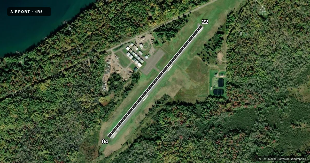
Airport sketch
Runways drawn to scale from FAA survey coordinates, rendered over satellite imagery. Not for navigation.
Approaches & charts
Services on the field
Fuel grades, oxygen, maintenance, ramp storage and lighting — as declared to the FAA by the airport operator.
Fuel & services
- Fuel
- Not available
- Oxygen (bottled)
- Not available
- Oxygen (bulk)
- Not available
- Airframe repair
- Not available
- Power plant repair
- Not available
Ramp & ground
- Transient storage
- Tie-down
- Landing fee
- No fee published
- Customs
- Not available
- Lighting schedule
- SEE RMK
- Beacon schedule
- SS-SR
- Beacon
- White / Green (civil land)(WG)
- Wind indicator
- Lighted
- Segmented circle
- No
Fuel & FBOs
Cheapest 100LL and Jet A on the field and nearby. Always confirm with the FBO before taxi.
Airport notes
Surface conditions, obstructions, local procedures, lighting outages and other notes published with each FAA cycle.
General notes
- DEER & WATERFOWL ON & INVOF ARPT.
- FOR CD CTC MINNEAPOLIS ARTCC AT 651-463-5588.
Lighting notes
- ACTVT REIL RWY 04; PAPI RWY 04 & 22 - CTAF. MIRL RWY 04/22 PRESET TO LOW SS-SR, TO INCR INTST & ACTVT - CTAF.
Approach & departure obstructions
- 2240 FT TREES 190 FT FM RWY END, 230 FT L.
VFR map & nearby airports
VFR sectional. Tap any ICAO chip to open that airport.
Key facts · 4R5
Answer card- ICAO
- 4R5
- Name
- MAJOR GILBERT FLD
- Location
- LA POINTE, WISCONSIN
- Elevation
- 648.6 ft MSL
- Traffic pattern altitude
- 1,648.6 ft MSL (1,000 AGL)
- Control tower
- Non-towered (use CTAF)
- Total runways
- 1
- Longest runway
- 04/22 · 3,000 ft
- Published ILS approaches
- 0
- Published frequencies
- 1
- Magnetic variation
- 0°
- Current flight rules
- MVFR
- Current wind
- 010° at 14 kt
- Favored runway now
- RWY 04
Major Gilbert Fld is in La Pointe, Wisconsin. The field elevation is 648.6 ft MSL. It has one runway, 04/22, which is 3,000 ft long and asphalt. There is no control tower. CTAF is 122.9.
No ILS approaches are published for 4R5. The pattern altitude is not published, so use the standard 1,000 ft AGL for light piston operations unless the current Chart Supplement says otherwise. The published remarks matter here. There are 40 ft trees near the runway end on the 04 side. Runway 04 has REIL lighting that is activated by CTAF. PAPI is available on runways 04 and 22. The medium intensity runway lights on both ends are preset low from sunset to sunrise. They can be increased in intensity and activated by CTAF.
There are no on-field FBOs listed. Check with the airport operator or the FBO directly by phone before arrival if you need fuel or ramp details. Deer and waterfowl are reported on and near the airport, so keep a sharp scan on taxi, takeoff and landing. For clearance delivery, contact Minneapolis ARTCC at 651-463-5588. The runway is short enough that a careful performance check is smart. This is especially true if you are arriving heavy or with a tailwind.