METAR & TAF KIWD
Current METAR
Observed 19:56Z
KIWD 271956Z AUTO 33009KT 10SM FEW038 25/18 A2976 RMK AO2 SLP069 T02500183
- Wind
- 330° @ 9 kt
- Visibility
- 10 SM
- Temp / Dew
- 25°C / 18°C
- Altimeter
- 29.76 inHg
- Clouds
- FEW
- Density alt
- 2,924 ft
- Ceiling
- Unlimited
- Rules
- VFR
Airport info & contacts
Manager on record, flight service, ARTCC, attendance schedule and pattern altitude — published by the FAA and refreshed every 28 days.
Location
- From city
- 5 NM NNE
- VFR sectional
- GREEN BAY
- ARTCC
- ZMP · MINNEAPOLIS
- NOTAM facility
- IWD (NOTAM-D)
Airport manager
- Name
- JEREMY BUSCH
- Phone
- 906-932-3121
- Address
- E5560 AIRPORT RD, IRONWOOD MI 49938-9202
Flight service · Hours
- FSS GRB
- GREEN BAY1-800-WX-BRIEF
- Attendance
- 0500-1930
Frequencies
Tap any row to copy the frequency to your clipboard.
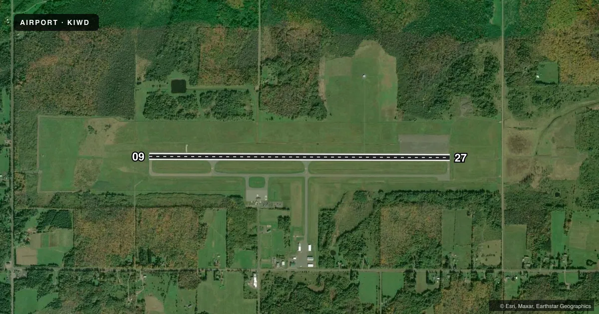
Runways & pattern
Full pagePattern entry · RWY 27
LEFT TRAFFICRunway end performance
| End | TORA | TODA | ASDA | LDA | VGSI | Approach lights | Obstruction |
|---|---|---|---|---|---|---|---|
| 09 | 6,501' | 6,501' | 6,501' | 6,501' | PAPI 4-box left(3°) | — | 97', trees, 2817' from thr, 587' R of cntrln, slope 26 |
| 27 | 6,501' | 6,501' | 6,501' | 6,501' | — | MALSR | 104', trees, 4578' from thr, 480' R of cntrln, slope 42 |
Declared distances in feet. TORA = takeoff run available, TODA = takeoff distance, ASDA = accelerate-stop, LDA = landing distance.
Airport sketch
Runways drawn to scale from FAA survey coordinates, rendered over satellite imagery. Not for navigation.
Approaches & charts
ILS · 1
Services on the field
Fuel grades, oxygen, maintenance, ramp storage and lighting — as declared to the FAA by the airport operator.
Fuel & services
- Fuel
- 100LLA
- Oxygen (bottled)
- Not available
- Oxygen (bulk)
- Not available
Ramp & ground
- Transient storage
- Tie-down
- Hangar
- Landing fee
- Yes
- Customs
- Not available
- Lighting schedule
- SEE RMK
- Beacon schedule
- SS-SR
- Beacon
- White / Green (civil land)(WG)
- Wind indicator
- Lighted
- Segmented circle
- Yes
Fuel & FBOs
Cheapest 100LL and Jet A on the field and nearby. Always confirm with the FBO before taxi.
Airport notes
Surface conditions, obstructions, local procedures, lighting outages and other notes published with each FAA cycle.
General notes
- VARIOUS WILDLIFE ON & INVOF ARPT.
- ARPT SIGNS MAY BE SNOW COVD DRG WINTER MONTHS.
- BE ALERT FOR PAEW DRG SNOW REMOVAL.
- ARFF PSNL MNT CTAF DRG ALL SKEDD ACR OPS.
- ARPT PSNL MNT CTAF DRG ALL SKEDD ACR OPS TO PRVD SFC COND RPRTS DRG WINTER WX.
- COLD TEMPERATURE AIRPORT. ALTITUDE CORRECTION REQUIRED AT OR BELOW -26C.
- SFC CONDS UNMON 2100-0500.
- FOR CD IF UNA TO CTC ON FSS FREQ, CTC MINNEAPOLIS ARTCC AT 651-463-5588.
Lighting notes
- ACTVT MALSR RWY 27; REIL RWY 09; PAPI RWY 09; HIRL RWY 09/27 - CTAF.
Runway surface & condition
- 09/27PCR VALUE: 110/F/B/X/T
Other notes
- ARPT CLSD TO UNSKED ACR OPS GTR THAN 30 PAX SEATS EXC 48 HR PPR CALL AMGR.
- WAIVED WITH FUEL PURCHASE.
VFR map & nearby airports
VFR sectional. Tap any ICAO chip to open that airport.
Key facts · KIWD
Answer card- ICAO
- KIWD
- Name
- GOGEBIC/IRON COUNTY
- Location
- IRONWOOD, MICHIGAN
- Elevation
- 1,230.3 ft MSL
- Traffic pattern altitude
- 2,230.3 ft MSL (1,000 AGL)
- Control tower
- Non-towered (use CTAF)
- Total runways
- 1
- Longest runway
- 09/27 · 6,502 ft
- Published ILS approaches
- 1
- Published frequencies
- 2
- Magnetic variation
- 0°
- Current flight rules
- VFR
- Current wind
- 330° at 9 kt
- Favored runway now
- RWY 27
Gogebic-Iron County Airport sits in Ironwood, Michigan. Field elevation is 1,230.3 ft MSL. The airport has one runway, 09/27, which is 6,502 ft long. There is no control tower. CTAF and UNICOM are both 122.8. The published pattern altitude is not listed, so use the standard 1,000 ft AGL for light piston aircraft unless the current Chart Supplement says otherwise.
Runway 27 has an ILS. Runway 27 also has MALSR lighting. Runway 09 has REIL and PAPI. High intensity runway lighting is available for both runway ends on CTAF. The on-field FBO is Gogebic-Iron County Airport. It carries 100LL and Jet A. Landing fees are waived with fuel purchase.
This is a cold weather field. Airport personnel maintain the CTAF during scheduled aircraft operations to pass surface condition reports in winter. Surface conditions are unmonitored from 2100 to 0500. Snow removal traffic can be active, so watch for personnel and equipment on the field. Wildlife is also noted in the airport area. The airport is closed to unscheduled aircraft operations with more than 30 passenger seats unless prior permission is arranged 48 hours ahead. For a first visit, plan for winter ops. Check the current Chart Supplement for any changes. Verify the latest field status with the airport operator or the FBO directly by phone.