METAR & TAF KBDJ
KBDJ does not publish a METAR.
Showing the nearest reporting station: KARV (LAKELAND/NOBLE F LEE MEML FLD) · 13.0 NM away. Conditions at KBDJ may differ.
METAR · KARV
Observed 19:15Z
KARV 271915Z AUTO 32010KT 10SM SCT026 SCT031 28/22 A2970 RMK AO2 T02820220
- Wind
- 320° @ 10 kt
- Visibility
- 10 SM
- Temp / Dew
- 28°C / 22°C
- Altimeter
- 29.70 inHg
- Clouds
- SCT
- Density alt
- 3,894 ft
- Ceiling
- Unlimited
- Rules
- VFR
Airport info & contacts
Manager on record, flight service, ARTCC, attendance schedule and pattern altitude — published by the FAA and refreshed every 28 days.
Location
- From city
- 2 NM N
- VFR sectional
- GREEN BAY
- ARTCC
- ZMP · MINNEAPOLIS
- NOTAM facility
- GRB (NOTAM-D)
Airport manager
- Name
- JOE SALAJA
- Phone
- 414-333-5521
- Address
- 5927 AIRPORT RD, BOULDER JUNCTION WI 54512
Flight service · Hours
- FSS GRB
- GREEN BAY1-800-WX-BRIEF
- Attendance
- MAY-NOV · Unattended
- DEC-APR · CLSD
Frequencies
Tap any row to copy the frequency to your clipboard.
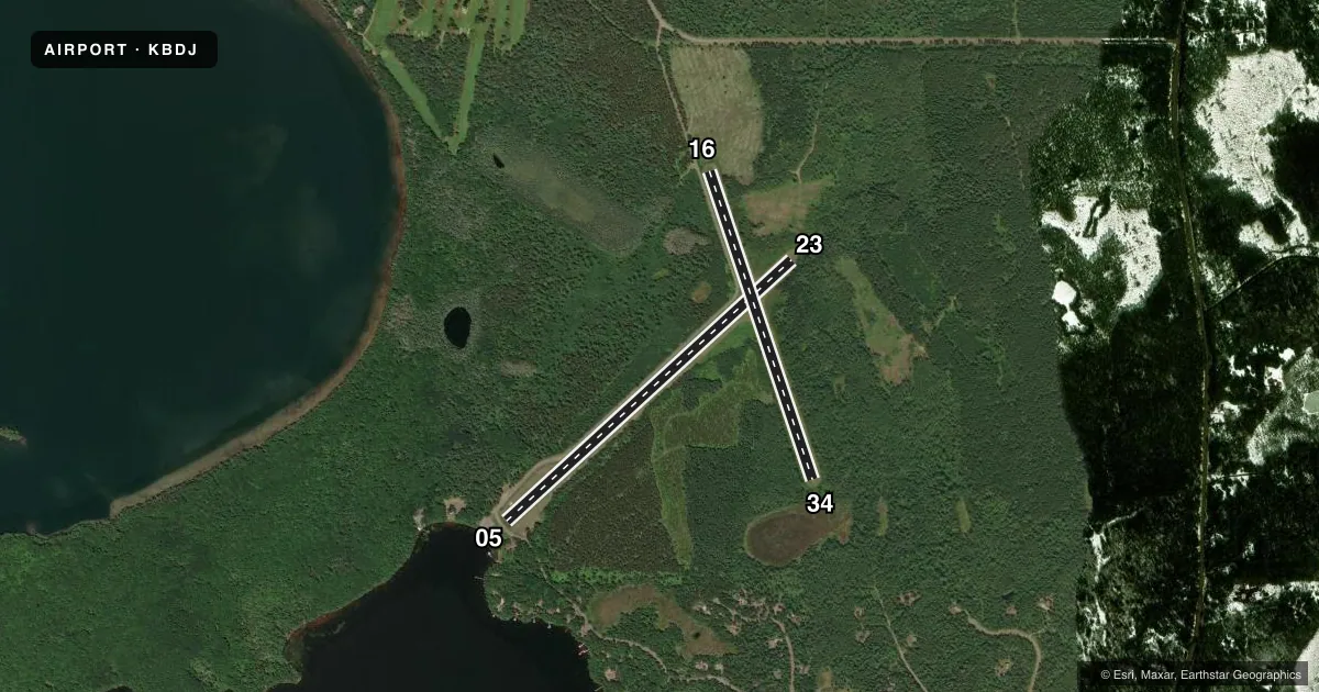
Runways & pattern
Full pagePattern entry · RWY 34
LEFT TRAFFIC| Runway | Heading (°M) | Length | Surface | Traffic |
|---|---|---|---|---|
| 05/23 | 47° / 227° | 3,821 ft | TURF | Standard L |
| 16/34Favored | 160° / 340° | 3,214 ft | TURF | Standard L |
Runway end performance
| End | TORA | TODA | ASDA | LDA | VGSI | Approach lights | Obstruction |
|---|---|---|---|---|---|---|---|
| 05 | — | — | — | — | — | — | 15', road, 20' from thr, 125' R of cntrln, slope 1 |
| 23 | — | — | — | — | — | — | 50', trees, 0' from thr, 115' R of cntrln, slope 0 |
| 16 | — | — | — | — | — | — | 15', road, 0' from thr, 100' R of cntrln, slope 0 |
| 34 | — | — | — | — | — | — | 50', trees, 0' from thr, 100' R of cntrln, slope 0 |
Declared distances in feet. TORA = takeoff run available, TODA = takeoff distance, ASDA = accelerate-stop, LDA = landing distance.
Airport sketch
Runways drawn to scale from FAA survey coordinates, rendered over satellite imagery. Not for navigation.
Approaches & charts
Services on the field
Fuel grades, oxygen, maintenance, ramp storage and lighting — as declared to the FAA by the airport operator.
Fuel & services
- Fuel
- Not available
- Oxygen (bottled)
- Not available
- Oxygen (bulk)
- Not available
- Airframe repair
- Not available
- Power plant repair
- Not available
Ramp & ground
- Transient storage
- Tie-down
- Landing fee
- No fee published
- Customs
- Not available
- Wind indicator
- Yes
- Segmented circle
- No
Fuel & FBOs
Cheapest 100LL and Jet A on the field and nearby. Always confirm with the FBO before taxi.
Airport notes
Surface conditions, obstructions, local procedures, lighting outages and other notes published with each FAA cycle.
General notes
- ARPT NOT PLOWED WINTER MONTHS.
- FOR CD CTC MINNEAPOLIS ARTCC AT 651-463-5588.
- WILDLIFE ON & INVOF ARPT.
Approach & departure obstructions
- 05MKD WITH YELLOW A-FRAMES.
- 16MKD WITH YELLOW A-FRAMES.
- 23MKD WITH YELLOW A-FRAMES.
- 34MKD WITH YELLOW A-FRAMES.
- 05MKD WITH YELLOW A-FRAME.
- 16MKD WITH YELLOW A-FRAME.
- 23MKD WITH YELLOW A-FRAME.
- 34MKD WITH YELLOW A-FRAME.
- 05APCH RATIO 20:1 TO DSPLCD THR.
- 16APCH RATIO 18:1 TO DSPLCD THR; 15 FT ROAD 270 FT FM DSPCLD THR, 100 FT R.
- 23APCH RATIO 6:1 TO DSPLCD THR; 50 FT TREES 310 FT FM DSPLCD THR, 115 FT L.
- 34APCH RATIO 3:1 TO DSPLCD THR; 65 FT TREES 210 FT FM DSPLCD THR, 1025 FT L/R.
VFR map & nearby airports
VFR sectional. Tap any ICAO chip to open that airport.
Key facts · KBDJ
Answer card- ICAO
- KBDJ
- Name
- BOULDER JUNCTION PAYZER
- Location
- BOULDER JUNCTION, WISCONSIN
- Elevation
- 1,662 ft MSL
- Traffic pattern altitude
- 2,662 ft MSL (1,000 AGL)
- Control tower
- Non-towered (use CTAF)
- Total runways
- 2
- Longest runway
- 05/23 · 3,821 ft
- Published ILS approaches
- 0
- Published frequencies
- 1
- Magnetic variation
- 1°
- Current flight rules
- VFR
- Current wind
- 320° at 10 kt
- Favored runway now
- RWY 34
Boulder Junction Payzer Airport sits in Boulder Junction, Wisconsin. Field elevation is 1,662 ft MSL. The airport has two turf runways. The longest is runway 05/23 at 3,821 ft. There is no control tower. CTAF is 122.9. No ILS approaches are published.
Pattern altitude is not published. Use the standard 1,000 ft AGL pattern unless the current Chart Supplement or local guidance says otherwise. That puts the light piston pattern at about 2,662 ft MSL based on the field elevation. Verify before you fly. Runway 05 and runway 16 have displaced thresholds marked with yellow A-frames. Runway 34 also has a displaced threshold marked the same way. The airport is not plowed in winter months. Wildlife is reported on and near the airport, so expect a close scan on rollout and in the pattern.
No on-field FBOs are listed. If you need fuel or local services, contact the airport operator or call the field directly before arrival. For clearance delivery, the published contact is Minneapolis ARTCC at 651-463-5588. This is a turf field in north Wisconsin, so plan for surface condition checks, soft-field technique and seasonal performance changes. Verify runway condition and any local restrictions before departure.