METAR & TAF KLNL
Current METAR
Observed 19:35Z
KLNL 271935Z AUTO 01007KT 10SM SCT025 BKN034 OVC055 27/20 A2974 RMK AO2 T02710203
- Wind
- 010° @ 7 kt
- Visibility
- 10 SM
- Temp / Dew
- 27°C / 20°C
- Altimeter
- 29.74 inHg
- Clouds
- OVC
- Density alt
- 3,778 ft
- Ceiling
- 3,400 ft AGL
- Rules
- VFR
Airport info & contacts
Manager on record, flight service, ARTCC, attendance schedule and pattern altitude — published by the FAA and refreshed every 28 days.
Location
- From city
- 1 NM SE
- VFR sectional
- GREEN BAY
- ARTCC
- ZMP · MINNEAPOLIS
- NOTAM facility
- LNL (NOTAM-D)
Airport manager
- Name
- BRUCE GARRISON
- Phone
- 715-547-3337
- Address
- PO BOX 327, LAND O'LAKES WI 54540
Flight service · Hours
- FSS GRB
- GREEN BAY1-800-WX-BRIEF
- Attendance
- TUES-SAT · 0700-1600
Frequencies
Tap any row to copy the frequency to your clipboard.
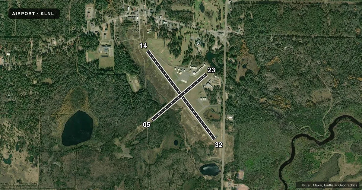
Runways & pattern
Full pagePattern entry · RWY 05
LEFT TRAFFIC| Runway | Heading (°M) | Length | Surface | Traffic |
|---|---|---|---|---|
| 14/32 | 141° / 321° | 4,000 ft | ASPH | Standard L |
| 05/23Favored | 48° / 228° | 2,577 ft | TURF | Standard L |
Runway end performance
| End | TORA | TODA | ASDA | LDA | VGSI | Approach lights | Obstruction |
|---|---|---|---|---|---|---|---|
| 14 | — | — | — | — | PAPI 2-box left(4°) | — | 15', road, 200' from thr, 50' R of cntrln, slope 1 |
| 32 | — | — | — | — | PAPI 2-box left(3°) | — | 18', road, 200' from thr, 245' R of cntrln, slope 1 |
| 05 | — | — | — | — | — | — | 34', trees, 0' from thr, 100' R of cntrln, slope 0 |
| 23 | — | — | — | — | — | — | 53', trees, 285' from thr, 120' R of cntrln, slope 5 |
Declared distances in feet. TORA = takeoff run available, TODA = takeoff distance, ASDA = accelerate-stop, LDA = landing distance.
Airport sketch
Runways drawn to scale from FAA survey coordinates, rendered over satellite imagery. Not for navigation.
Approaches & charts
Services on the field
Fuel grades, oxygen, maintenance, ramp storage and lighting — as declared to the FAA by the airport operator.
Fuel & services
- Fuel
- 100LLMOGAS
- Oxygen (bottled)
- Not available
- Oxygen (bulk)
- Not available
- Airframe repair
- Not available
- Power plant repair
- Not available
Ramp & ground
- Transient storage
- Tie-down
- Hangar
- Landing fee
- No fee published
- Customs
- Not available
- Lighting schedule
- SEE RMK
- Beacon schedule
- SS-SR
- Beacon
- White / Green (civil land)(WG)
- Wind indicator
- Lighted
- Segmented circle
- Yes
Fuel & FBOs
Cheapest 100LL and Jet A on the field and nearby. Always confirm with the FBO before taxi.
Airport notes
Surface conditions, obstructions, local procedures, lighting outages and other notes published with each FAA cycle.
General notes
- DEER ON & INVOF ARPT.
- FOR CD CTC MINNEAPOLIS ARTCC AT 651-463-5588.
Lighting notes
- ACTVT REIL RWY 14 & 32; PAPI RWY 14 & 32; MIRL RWY 14/32 - CTAF. SS-SR MIRL RWY 14/32 PRESET TO LOW INTST; INCR INTST - CTAF.
Fuel notes
- 100LLSELF SVC H24 WITH CREDIT CARD.
Runway surface & condition
- 05/23CLSD NOV 15 - APR 15.
Approach & departure obstructions
- 14INTMT USE ROAD 0-200 FT FM RWY END 50-100 FT L.
- 32ROAD 187 FT FM RWY END 250 FT R.
- 14APCH RATIO 20:1 TO DTHR.
- 05YELLOW CONES.
- 23YELLOW CONES.
- 05CTL OBSTN EXCEEDS 45 DEG SLOPE.
- 14APCH RATIO 20:1 TO DTHR.
- 23APCH RATIO 16:1 TO DTHR; 94 FT TREES 1490 FT FM DTHR 135 L.
VFR map & nearby airports
VFR sectional. Tap any ICAO chip to open that airport.
Key facts · KLNL
Answer card- ICAO
- KLNL
- Name
- KINGS LAND O' LAKES
- Location
- LAND O' LAKES, WISCONSIN
- Elevation
- 1,705.6 ft MSL
- Traffic pattern altitude
- 2,705.6 ft MSL (1,000 AGL)
- Control tower
- Non-towered (use CTAF)
- Total runways
- 2
- Longest runway
- 14/32 · 4,000 ft
- Published ILS approaches
- 0
- Published frequencies
- 2
- Magnetic variation
- 2°
- Current flight rules
- VFR
- Current wind
- 010° at 7 kt
- Favored runway now
- RWY 05
Kings Land O' Lakes is in Land O' Lakes, Wisconsin. The field elevation is 1,705.6 ft MSL. It has two runways. The longest is runway 14/32 at 4,000 ft on asphalt. Runway 05/23 is 2,577 ft turf. There is no control tower. CTAF and UNICOM are both 122.8. No ILS approaches are published here.
The published pattern altitude is not listed, so use the standard 1,000 ft AGL for light piston traffic unless the current FAA Chart Supplement says otherwise. Kings Land O' Lakes Airport is on the field and carries 100LL and MOGAS. Self-service 100LL is available 24 hours with a credit card. Runway 14/32 has runway end identifier lights, PAPI and medium intensity runway lights that are controlled on CTAF. The lights are preset to low from sunset to sunrise. They can be raised by CTAF.
This is a high-elevation Wisconsin strip, so watch performance on warm days. Deer are reported on and near the airport. Runway 05 has yellow cones. Runway 23 has yellow cones. There are published obstruction notes for both runway ends, so a first-time arrival should review the current Chart Supplement and plan the approach carefully. For clearance delivery, Minneapolis ARTCC can be reached at 651-463-5588.