METAR & TAF 40D
40D does not publish a METAR.
Showing the nearest reporting station: KEGV (EAGLE RIVER UNION) · 10.5 NM away. Conditions at 40D may differ.
METAR · KEGV
Observed 01:15Z
KEGV 270115Z AUTO 00000KT 10SM CLR 25/20 A2983 RMK AO2 T02530197
- Wind
- 000° @ 0 kt
- Visibility
- 10 SM
- Temp / Dew
- 25°C / 20°C
- Altimeter
- 29.83 inHg
- Clouds
- CLR
- Density alt
- 3,342 ft
- Ceiling
- Unlimited
- Rules
- VFR
Airport info & contacts
Manager on record, flight service, ARTCC, attendance schedule and pattern altitude — published by the FAA and refreshed every 28 days.
Location
- From city
- 3 NM SE
- VFR sectional
- GREEN BAY
- Pattern altitude
- 800 ft AGL · 2,437 ft MSL
- ARTCC
- ZMP · MINNEAPOLIS
- NOTAM facility
- GRB (NOTAM-D)
Airport manager
- Name
- JORDAN GENSLER
- Phone
- (715) 360-0631
- Address
- 6181 GENSLER RD, THREE LAKES WI 54562-0562
Flight service · Hours
- FSS GRB
- GREEN BAY1-800-WX-BRIEF
- Attendance
- Unattended
Frequencies
Tap any row to copy the frequency to your clipboard.
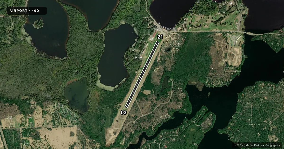
Runways & pattern
Full pagePattern entry · RWY 03
LEFT TRAFFICRunway end performance
| End | TORA | TODA | ASDA | LDA | VGSI | Approach lights | Obstruction |
|---|---|---|---|---|---|---|---|
| 21 | — | — | — | — | PAPI 2-box right(3°) | — | — |
Declared distances in feet. TORA = takeoff run available, TODA = takeoff distance, ASDA = accelerate-stop, LDA = landing distance.
Airport sketch
Runways drawn to scale from FAA survey coordinates, rendered over satellite imagery. Not for navigation.
Approaches & charts
Services on the field
Fuel grades, oxygen, maintenance, ramp storage and lighting — as declared to the FAA by the airport operator.
Fuel & services
- Fuel
- Not available
- Oxygen (bottled)
- Not available
- Oxygen (bulk)
- Not available
- Airframe repair
- Not available
- Power plant repair
- Not available
Ramp & ground
- Transient storage
- Tie-down
- Landing fee
- No fee published
- Customs
- Not available
- Lighting schedule
- SS-SR
- Beacon schedule
- SS-SR
- Beacon
- White / Green (civil land)(WG)
- Wind indicator
- Yes
- Segmented circle
- No
Fuel & FBOs
Cheapest 100LL and Jet A on the field and nearby. Always confirm with the FBO before taxi.
Airport notes
Surface conditions, obstructions, local procedures, lighting outages and other notes published with each FAA cycle.
General notes
- 1683 FT AGL/3327 FT MSL TWR 8.5 NM SW.
- CONFIRM RUNWAY CONDITIONS WITH AIRPORT MANAGER NOV - MAY.
- FOR CD CTC MINNEAPOLIS ARTCC AT 651-463-5588.
- WILDLIFE ON & INVOF ARPT.
Runway surface & condition
- 03/21RY 3/21 NSTD LIRL.
Approach & departure obstructions
- 03MKD WITH YELLOW CONES.
- 21MKD WITH YELLOW CONES.
Other notes
- MANAGEREMAIL ADDRESS: SUNNYSKIESAVIATION@GMAIL.COM (ALL LOWER CASE)
VFR map & nearby airports
VFR sectional. Tap any ICAO chip to open that airport.
Key facts · 40D
Answer card- ICAO
- 40D
- Name
- THREE LAKES MUNI
- Location
- THREE LAKES, WISCONSIN
- Elevation
- 1,637.2 ft MSL
- Traffic pattern altitude
- 2,437.2 ft MSL (800 AGL)
- Control tower
- Non-towered (use CTAF)
- Total runways
- 1
- Longest runway
- 03/21 · 3,400 ft
- Published ILS approaches
- 0
- Published frequencies
- 2
- Magnetic variation
- 1°
- Current flight rules
- VFR
- Current wind
- 000° at 0 kt
- Favored runway now
- –
Three Lakes Muni sits in Three Lakes, Wisconsin. The field elevation is 1,637.2 ft MSL. It has one runway. Runway 03/21 is 3,400 ft long and turf. The pattern altitude is 800 ft AGL, which is 2,437.2 ft MSL. There is no control tower on the field. CTAF and UNICOM are both 122.7.
No ILS approaches are published here. That matters if you are planning an arrival in lower weather. Check the current FAA Chart Supplement for the latest approach and airport data before you go. The published remarks also say runway conditions should be confirmed with the airport manager from November through May. Wildlife is reported on and near the airport. Keep a sharp scan on taxi, takeoff and landing.
Runway 03/21 has nonstandard low intensity runway lights. Runway 03 and runway 21 are both marked with yellow cones. The published remarks also note a tower 8.5 NM southwest of the airport that sits at 3,327 ft MSL. No on-field FBOs are listed, so contact the airport operator directly before arrival, or call the field on CTAF or UNICOM for current service details. For clearance delivery, the published contact is Minneapolis ARTCC at 651-463-5588.