METAR & TAF Y55
Y55 does not publish a METAR.
Showing the nearest reporting station: KAIG (LANGLADE COUNTY) · 23.4 NM away. Conditions at Y55 may differ.
METAR · KAIG
Observed 18:15Z
KAIG 261815Z AUTO 21007KT 10SM CLR 28/19 A2993 RMK AO2 T02770186
- Wind
- 210° @ 7 kt
- Visibility
- 10 SM
- Temp / Dew
- 28°C / 19°C
- Altimeter
- 29.93 inHg
- Clouds
- CLR
- Density alt
- 3,594 ft
- Ceiling
- Unlimited
- Rules
- VFR
Airport info & contacts
Manager on record, flight service, ARTCC, attendance schedule and pattern altitude — published by the FAA and refreshed every 28 days.
Location
- From city
- 3 NM SW
- VFR sectional
- GREEN BAY
- ARTCC
- ZMP · MINNEAPOLIS
- NOTAM facility
- GRB (NOTAM-D)
Airport manager
- Name
- TIM BAHR
- Phone
- 715-902-0188
- Address
- 4928 E LAKEVIEW ST, CRANDON WI 54520
Flight service · Hours
- FSS GRB
- GREEN BAY1-800-WX-BRIEF
- Attendance
- Unattended
Frequencies
Tap any row to copy the frequency to your clipboard.
Runways & pattern
Full pagePattern entry · RWY 19
LEFT TRAFFIC| Runway | Heading (°M) | Length | Surface | Traffic |
|---|---|---|---|---|
| 12/30 | 110° / 290° | 3,550 ft | ASPH | Standard L |
| 01/19Favored | 3° / 183° | 2,742 ft | TURF | Standard L |
Runway end performance
| End | TORA | TODA | ASDA | LDA | VGSI | Approach lights | Obstruction |
|---|---|---|---|---|---|---|---|
| 30 | — | — | — | — | — | — | 44', trees, 730' from thr, 300' R of cntrln, slope 12 |
Declared distances in feet. TORA = takeoff run available, TODA = takeoff distance, ASDA = accelerate-stop, LDA = landing distance.
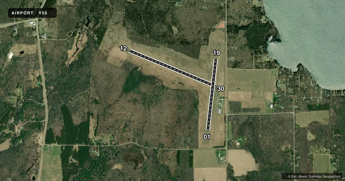
Airport sketch
Runways drawn to scale from FAA survey coordinates, rendered over satellite imagery. Not for navigation.
Approaches & charts
Services on the field
Fuel grades, oxygen, maintenance, ramp storage and lighting — as declared to the FAA by the airport operator.
Fuel & services
- Fuel
- Not available
- Oxygen (bottled)
- Not available
- Oxygen (bulk)
- Not available
- Airframe repair
- Not available
- Power plant repair
- Not available
Ramp & ground
- Transient storage
- Tie-down
- Landing fee
- No fee published
- Customs
- Not available
- Lighting schedule
- SEE RMK
- Beacon schedule
- SS-SR
- Beacon
- White / Green (civil land)(WG)
- Wind indicator
- Lighted
- Segmented circle
- No
Fuel & FBOs
Cheapest 100LL and Jet A on the field and nearby. Always confirm with the FBO before taxi.
Airport notes
Surface conditions, obstructions, local procedures, lighting outages and other notes published with each FAA cycle.
General notes
- OCNL DEER ON & INVOF ARPT.
- FOR CD CTC MINNEAPOLIS ARTCC AT 651-463-5588.
Lighting notes
- MIRL RWY 12/30 PRESET TO LOW SS-SR, INCR INTST AND ACTVT - CTAF.
Approach & departure obstructions
- 12MARKINGS FADED.
- 30MARKINGS FADED.
- 01MKD WITH YELLOW CONES.
- 19MKD WITH YELLOW CONES.
VFR map & nearby airports
VFR sectional. Tap any ICAO chip to open that airport.
Key facts · Y55
Answer card- ICAO
- Y55
- Name
- CRANDON/STEVE CONWAY MUNI
- Location
- CRANDON, WISCONSIN
- Elevation
- 1,650 ft MSL
- Traffic pattern altitude
- 2,650 ft MSL (1,000 AGL)
- Control tower
- Non-towered (use CTAF)
- Total runways
- 2
- Longest runway
- 12/30 · 3,550 ft
- Published ILS approaches
- 0
- Published frequencies
- 1
- Magnetic variation
- 3°
- Current flight rules
- VFR
- Current wind
- 210° at 7 kt
- Favored runway now
- RWY 19
Crandon/Steve Conway Muni sits in Crandon, Wisconsin. Field elevation is 1,650 ft MSL. The airport has two runways. The longest is runway 12/30 at 3,550 ft asphalt. Runway 01/19 is 2,742 ft turf. There is no control tower. CTAF is 122.9.
No ILS approaches are published here. Pattern altitude is not published, so use the standard 1,000 ft AGL for light piston traffic unless the current Chart Supplement says otherwise. That puts the pattern at 2,650 ft MSL based on the listed field elevation. For clearance delivery, contact Minneapolis ARTCC at 651-463-5588.
A few remarks matter for planning. Deer are reported on and near the airport. Runway 01 is marked with yellow cones. Runway 19 is marked with yellow cones. Markings on runway 12 are faded. Markings on runway 30 are faded. The runway 12/30 lights are preset to low from sunset to sunrise. Use CTAF to increase intensity and activate them. There are no on-field FBOs listed, so verify fuel and services with the airport operator or the FBO directly by phone before you go. This is a non-towered field at 1,650 ft MSL, so expect normal self-announce traffic and pay attention to the deer issue, especially at dawn and dusk.