METAR & TAF KAIG
Current METAR
Observed 16:35Z
KAIG 271635Z AUTO 17004KT 10SM SCT010 OVC027 22/21 A2971 RMK AO2 T02240212
- Wind
- 170° @ 4 kt
- Visibility
- 10 SM
- Temp / Dew
- 22°C / 21°C
- Altimeter
- 29.71 inHg
- Clouds
- OVC
- Density alt
- 2,989 ft
- Ceiling
- 2,700 ft AGL
- Rules
- MVFR
Airport info & contacts
Manager on record, flight service, ARTCC, attendance schedule and pattern altitude — published by the FAA and refreshed every 28 days.
Location
- From city
- 2 NM NE
- VFR sectional
- GREEN BAY
- ARTCC
- ZMP · MINNEAPOLIS
- NOTAM facility
- AIG (NOTAM-D)
Airport manager
- Name
- DONALD BINTZ
- Phone
- 702-324-9966
- Address
- N3689 N LANGLADE RD, ANTIGO WI 54409
Flight service · Hours
- FSS GRB
- GREEN BAY1-800-WX-BRIEF
- Attendance
- MON-SAT · 0800-1700
- SUN · 0900-1600
Frequencies
Tap any row to copy the frequency to your clipboard.
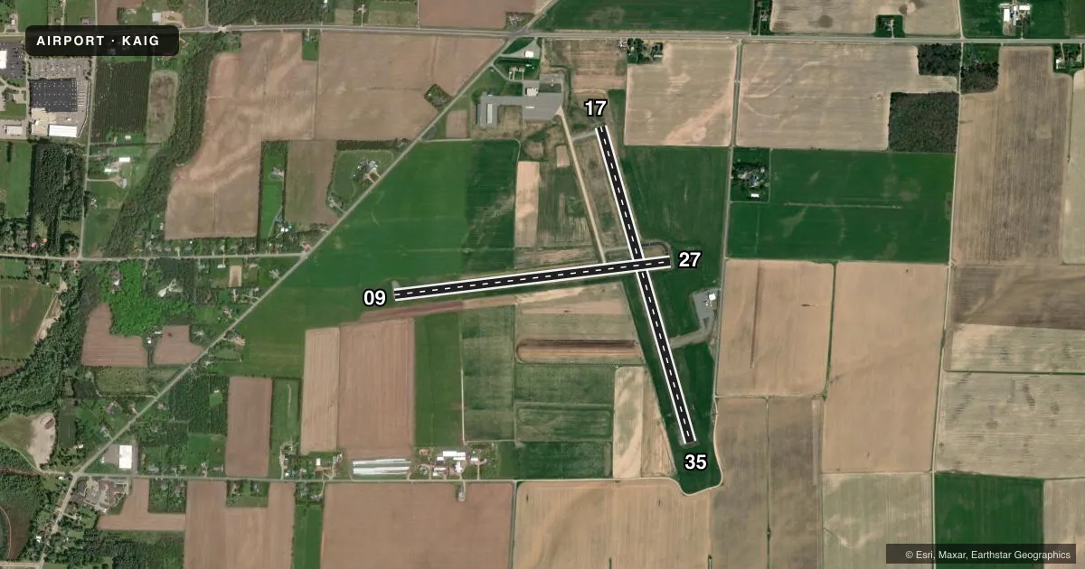
Runways & pattern
Full pagePattern entry · RWY 17
LEFT TRAFFIC| Runway | Heading (°M) | Length | Surface | Traffic |
|---|---|---|---|---|
| 17/35Favored | 162° / 342° | 4,010 ft | ASPH | Standard L |
| 09/27 | 81° / 261° | 3,400 ft | ASPH | Standard L |
Runway end performance
| End | TORA | TODA | ASDA | LDA | VGSI | Approach lights | Obstruction |
|---|---|---|---|---|---|---|---|
| 17 | — | — | — | — | PAPI 2-box left(3°) | — | — |
| 35 | — | — | — | — | PAPI 2-box left(3°) | — | — |
| 09 | — | — | — | — | PAPI 2-box left(3°) | — | — |
| 27 | — | — | — | — | PAPI 2-box left(3°) | — | — |
Declared distances in feet. TORA = takeoff run available, TODA = takeoff distance, ASDA = accelerate-stop, LDA = landing distance.
Airport sketch
Runways drawn to scale from FAA survey coordinates, rendered over satellite imagery. Not for navigation.
Approaches & charts
Services on the field
Fuel grades, oxygen, maintenance, ramp storage and lighting — as declared to the FAA by the airport operator.
Fuel & services
- Fuel
- 100LLA
- Oxygen (bottled)
- Not available
- Oxygen (bulk)
- Not available
- Airframe repair
- Minor
- Power plant repair
- Minor
- Other services
- AGRI,INSTR,RNTL
Ramp & ground
- Transient storage
- Tie-down
- Hangar
- Landing fee
- No fee published
- Customs
- Not available
- Lighting schedule
- SEE RMK
- Beacon schedule
- SS-SR
- Beacon
- White / Green (civil land)(WG)
- Wind indicator
- Lighted
- Segmented circle
- No
Fuel & FBOs
Cheapest 100LL and Jet A on the field and nearby. Always confirm with the FBO before taxi.
Airport notes
Surface conditions, obstructions, local procedures, lighting outages and other notes published with each FAA cycle.
General notes
- FOR CD CTC MINNEAPOLIS ARTCC AT 651-463-5588.
Lighting notes
- MIRL RWY 17/35 & 09/27 PRESET TO LOW SS-SR; TO INCR INTST AND ACTVT REIL RWY 17 & 35; PAPI RWY 09, 17, 27 & 35 - CTAF.
Approach & departure obstructions
- 35PAPI UNUSBL BYD 7 DEGS LEFT OF CNTRLN.
VFR map & nearby airports
VFR sectional. Tap any ICAO chip to open that airport.
Key facts · KAIG
Answer card- ICAO
- KAIG
- Name
- LANGLADE COUNTY
- Location
- ANTIGO, WISCONSIN
- Elevation
- 1,523 ft MSL
- Traffic pattern altitude
- 2,523 ft MSL (1,000 AGL)
- Control tower
- Non-towered (use CTAF)
- Total runways
- 2
- Longest runway
- 17/35 · 4,010 ft
- Published ILS approaches
- 0
- Published frequencies
- 2
- Magnetic variation
- 2°
- Current flight rules
- MVFR
- Current wind
- 170° at 4 kt
- Favored runway now
- RWY 17
Langlade County Airport is in Antigo, Wisconsin. The field elevation is 1,523 ft MSL. It has two asphalt runways. The longest is 4,010 ft on runway 17/35. There is no control tower. CTAF and UNICOM are both 122.8. No ILS approaches are published.
Pattern altitude is not published. Use the standard 1,000 ft AGL for light piston operations unless the current Chart Supplement says otherwise. The airport sits in northern Wisconsin, so watch winter performance and density altitude on warmer days. Runway headings are 09/27 and 17/35. Magnetic variation is 2°. The published remarks matter here. Medium intensity runway lights on both runways are preset to low from sunset to sunrise. Use the CTAF to raise intensity and to activate the runway end identifier lights on 17 and 35. The PAPI on runway 35 is unusable beyond 7 degrees left of centerline.
1521, LLC is on the field. It carries 100LL and Jet A Prist. For clearance delivery, contact Minneapolis ARTCC at 651-463-5588 before departure if you need it. Pilots planning a first trip should review the lighting notes and the runway 35 PAPI limitation before arrival.