METAR & TAF KTKV
Current METAR
Observed 04:15Z
KTKV 270415Z AUTO 00000KT 2 1/2SM SCT095 SCT120 23/22 A2985 RMK AO2 T02310220 PWINO
- Wind
- 000° @ 0 kt
- Visibility
- 0.5 SM
- Temp / Dew
- 23°C / 22°C
- Altimeter
- 29.85 inHg
- Clouds
- SCT
- Density alt
- 2,890 ft
- Ceiling
- Unlimited
- Rules
- LIFR
Airport info & contacts
Manager on record, flight service, ARTCC, attendance schedule and pattern altitude — published by the FAA and refreshed every 28 days.
Location
- From city
- 3 NM W
- VFR sectional
- GREEN BAY
- ARTCC
- ZMP · MINNEAPOLIS
- NOTAM facility
- TKV (NOTAM-D)
Airport manager
- Name
- DAN ANDERSON
- Phone
- 715-453-1874
- Address
- 7350 S RIVER RD, TOMAHAWK WI 54487
Flight service · Hours
- FSS GRB
- GREEN BAY1-800-WX-BRIEF
- Attendance
- ALL
Frequencies
Tap any row to copy the frequency to your clipboard.
Runways & pattern
Full pagePattern entry · RWY 09
LEFT TRAFFICRunway end performance
| End | TORA | TODA | ASDA | LDA | VGSI | Approach lights | Obstruction |
|---|---|---|---|---|---|---|---|
| 09 | — | — | — | — | PAPI 2-box left(3°) | — | — |
| 27 | — | — | — | — | PAPI 2-box left(3°) | — | — |
Declared distances in feet. TORA = takeoff run available, TODA = takeoff distance, ASDA = accelerate-stop, LDA = landing distance.
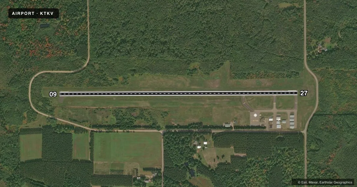
Airport sketch
Runways drawn to scale from FAA survey coordinates, rendered over satellite imagery. Not for navigation.
Approaches & charts
Services on the field
Fuel grades, oxygen, maintenance, ramp storage and lighting — as declared to the FAA by the airport operator.
Fuel & services
- Fuel
- 100LL
- Oxygen (bottled)
- Not available
- Oxygen (bulk)
- Not available
- Airframe repair
- Major
- Power plant repair
- Major
- Other services
- INSTR
Ramp & ground
- Transient storage
- Tie-down
- Hangar
- Landing fee
- No fee published
- Customs
- Not available
- Lighting schedule
- SEE RMK
- Beacon schedule
- SS-SR
- Beacon
- White / Green (civil land)(WG)
- Wind indicator
- Lighted
- Segmented circle
- Yes
Fuel & FBOs
Cheapest 100LL and Jet A on the field and nearby. Always confirm with the FBO before taxi.
Airport notes
Surface conditions, obstructions, local procedures, lighting outages and other notes published with each FAA cycle.
General notes
- DEER ON & INVOF ARPT.
- FOR CD CTC MINNEAPOLIS ARTCC AT 651-463-5588.
Lighting notes
- MIRL RWY 09/27 PRESET TO LOW SS-SR, TO INCR INTST AND ACTVT REIL RWYS 09 & 27; MIRL RWY 09/27 - CTAF. PAPI RWY 09 & 27 OPRS CONSLY.
Fuel notes
- 100LLFUEL AVBL 24 HRS WITH CREDIT CARD.
Other notes
- AIRFRAME & POWER PLANT REPAIRS BY PRIOR ARRANGEMENT CALL 715-453-2264 OR 453-3482.
VFR map & nearby airports
VFR sectional. Tap any ICAO chip to open that airport.
Key facts · KTKV
Answer card- ICAO
- KTKV
- Name
- TOMAHAWK RGNL
- Location
- TOMAHAWK, WISCONSIN
- Elevation
- 1,486.7 ft MSL
- Traffic pattern altitude
- 2,486.7 ft MSL (1,000 AGL)
- Control tower
- Non-towered (use CTAF)
- Total runways
- 1
- Longest runway
- 09/27 · 4,401 ft
- Published ILS approaches
- 0
- Published frequencies
- 2
- Magnetic variation
- 2°
- Current flight rules
- LIFR
- Current wind
- 000° at 0 kt
- Favored runway now
- –
Tomahawk Regional Airport sits in Tomahawk, Wisconsin. The field elevation is 1,486.7 ft MSL. It has one runway. Runway 09/27 is 4,401 ft of asphalt, so the field is straightforward for light piston work and smaller turbine traffic that fits the runway length. There is no control tower. CTAF and UNICOM are both 122.8.
No ILS approaches are published here. Pattern altitude is not published, so use the standard 1,000 ft AGL for light piston operations unless the current Chart Supplement says otherwise. The airport has one on-field FBO. Tomahawk Regional Airport carries AVGAS 100LL. Fuel is available 24 hours with credit card. The field also has airframe and powerplant repairs available by prior arrangement. Call ahead if you need maintenance support.
A few operational notes matter here. Deer are reported on and near the airport. The runway lights on 09/27 are preset low from sunset to sunrise. Use the CTAF to raise intensity and activate the runway end identifier lights for 09 and 27. Clearance delivery is handled through Minneapolis ARTCC. If you are planning an IFR arrival or departure, have that number ready before you go. The airport sits in north-central Wisconsin. Expect a non-towered field with standard rural traffic flow and keep an eye out for wildlife.