METAR & TAF KMDZ
Current METAR
Observed 15:35Z
KMDZ 271535Z AUTO 21006KT 10SM OVC010 27/26 A2970 RMK AO2 T02670262 PWINO
- Wind
- 210° @ 6 kt
- Visibility
- 10 SM
- Temp / Dew
- 27°C / 26°C
- Altimeter
- 29.70 inHg
- Clouds
- OVC
- Density alt
- 3,546 ft
- Ceiling
- 1,000 ft AGL
- Rules
- MVFR
Airport info & contacts
Manager on record, flight service, ARTCC, attendance schedule and pattern altitude — published by the FAA and refreshed every 28 days.
Location
- From city
- 3 NM SE
- VFR sectional
- GREEN BAY
- ARTCC
- ZMP · MINNEAPOLIS
- NOTAM facility
- MDZ (NOTAM-D)
Airport manager
- Name
- PATRICK COLWELL
- Phone
- 715-678-2152
- Address
- W5125 APPLE AVE, MEDFORD WI 54451
Flight service · Hours
- FSS GRB
- GREEN BAY1-800-WX-BRIEF
- Attendance
- 0800-1600
Frequencies
Tap any row to copy the frequency to your clipboard.
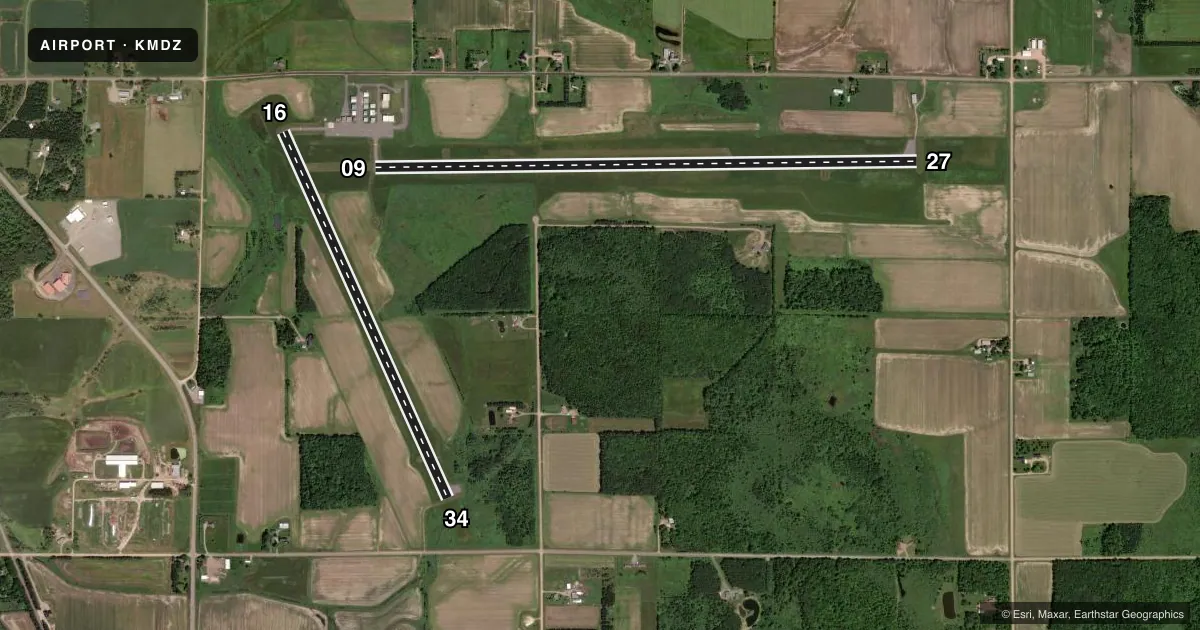
Runways & pattern
Full pagePattern entry · RWY 16
LEFT TRAFFIC| Runway | Heading (°M) | Length | Surface | Traffic |
|---|---|---|---|---|
| 09/27 | 89° / 269° | 6,000 ft | ASPH | Standard L |
| 16/34Favored | 156° / 336° | 4,435 ft | ASPH | Standard L |
Runway end performance
| End | TORA | TODA | ASDA | LDA | VGSI | Approach lights | Obstruction |
|---|---|---|---|---|---|---|---|
| 09 | — | — | — | — | PAPI 4-box left(3°) | — | — |
| 27 | — | — | — | — | PAPI 4-box left(3°) | — | — |
| 16 | — | — | — | — | PAPI 2-box left(3°) | — | — |
| 34 | — | — | — | — | PAPI 2-box left(3°) | — | — |
Declared distances in feet. TORA = takeoff run available, TODA = takeoff distance, ASDA = accelerate-stop, LDA = landing distance.
Airport sketch
Runways drawn to scale from FAA survey coordinates, rendered over satellite imagery. Not for navigation.
Approaches & charts
Services on the field
Fuel grades, oxygen, maintenance, ramp storage and lighting — as declared to the FAA by the airport operator.
Fuel & services
- Fuel
- 100LLA+
- Oxygen (bottled)
- Not available
- Oxygen (bulk)
- Not available
- Airframe repair
- Not available
- Power plant repair
- Not available
Ramp & ground
- Transient storage
- Tie-down
- Hangar
- Landing fee
- No fee published
- Customs
- Not available
- Lighting schedule
- SEE RMK
- Beacon schedule
- SS-SR
- Beacon
- White / Green (civil land)(WG)
- Wind indicator
- Lighted
- Segmented circle
- Yes
Fuel & FBOs
Cheapest 100LL and Jet A on the field and nearby. Always confirm with the FBO before taxi.
Airport notes
Surface conditions, obstructions, local procedures, lighting outages and other notes published with each FAA cycle.
General notes
- FOR TAKE OFF ON RY 34 LEFT TURN AFTER 1000 FT 'AGL.
- SEASONAL BIRDS ON & INVOF ARPT.
- FOR CD CTC MINNEAPOLIS ARTCC AT 651-463-5588.
Lighting notes
- ACTVT REIL RWY 09, 27 & 34; PAPI RWY 09, 27, 16 & 34; MIRL RWY 16/34 - CTAF. MIRL RWY 09/27 PRESET TO LOW SS-SR; TO INCR INTST & ACTVT - CTAF.
Fuel notes
- 100LLSELF SVC FUEL AVBL H24 VIA CREDIT CARD.
Other notes
- 2FOR SVC AFT HRS CALL 715-560-1018.
- MANAGEREMAIL ADDRESS: AIRPORT@CO.TAYLOR.WI.US
VFR map & nearby airports
VFR sectional. Tap any ICAO chip to open that airport.
Key facts · KMDZ
Answer card- ICAO
- KMDZ
- Name
- TAYLOR COUNTY
- Location
- MEDFORD, WISCONSIN
- Elevation
- 1,478.1 ft MSL
- Traffic pattern altitude
- 2,478.1 ft MSL (1,000 AGL)
- Control tower
- Non-towered (use CTAF)
- Total runways
- 2
- Longest runway
- 09/27 · 6,000 ft
- Published ILS approaches
- 0
- Published frequencies
- 2
- Magnetic variation
- 0°
- Current flight rules
- MVFR
- Current wind
- 210° at 6 kt
- Favored runway now
- RWY 16
Taylor County Airport sits in Medford, Wisconsin. Field elevation is 1,478.1 ft MSL. The airport has two asphalt runways. The longest is runway 09/27 at 6,000 ft. There is no control tower. CTAF and UNICOM are both 122.8. No ILS approaches are published here.
Pattern altitude is not published. Use 1,000 ft AGL for light piston operations unless the current Chart Supplement says otherwise. The on-field FBO is Taylor County Airport. It carries 100LL and Jet A Prist. Self-service 100LL is available 24 hours by credit card. For after-hours service, call the number in the Chart Supplement or the airport operator.
A few operational notes matter here. Seasonal birds are reported on and near the airport. Runway end identifier lights are active on runways 09, 27 and 34. PAPI is installed on all four runway ends. Runway 16/34 has medium intensity lighting controlled by CTAF. Runway 09/27 is preset low from sunset to sunrise. Use CTAF to raise intensity and activate it. For takeoff on runway 34, plan a left turn after 1,000 ft AGL. Clearance delivery is handled through Minneapolis ARTCC. If you are new to the field, verify current procedures in the FAA Chart Supplement before you go.